Portesham
Portesham Hellstone
The Hell Stone is an example of a Long Barrow with stone interior; it was the entrance to a Neolithic long barrow burial chamber that was originally covered by a mound of earth and consists of nine upright sarsen stones supporting a single capstone. There are several other long barrows in the vicinity; these were used before the round barrows of which there are about four hundred in the Bride Valley area west of Dorchester.
As the centuries passed the burial chamber collapsed and on the 11th of June 1886 a team of men came from Portland to restore it, incorrectly it seems, and failed to reposition the massive capstone. This was placed in position three years later on the 14th of August 1869 when eight quarry men came and completed the task using screw jacks.
Hutchins in his ‘History and Antiquities of the County of Dorset” says: “The common people call it Hellstone, and have a tradition that the devil flung it from Portland Pike, a north point of that island full in view, as he was diverting himself at quoits.” The opening of the barrow faces towards Portland. Hellstone is a local variant of the Old English ‘Heelstone’ or the Saxon word ‘Helian’ meaning to cover or conceal and refers to the capstone. The name has nothing to do with the Devil or his domain.
We have placed a photograph of the Hellstone in the photo area.


Chesil Churches
Dorset’s Chesil Bank is a 15-mile (25-km) shingle bar, which has impounded a coastal lagoon, The Fleet. This geographical feature has a long tradition as a beachhead for smuggling and as a danger to walkers and shipping. The belt of coastal country up to about 5km inland encompasses a number of parishes, which have been protected from the sea by the Chesil. The churches of five of these parishes are described here. From north-west to south-east these are Puncknowle, Abbotsbury, Portesham, Langton Herring and Fleet.
Puncknowle lies about 1km east of Swyre and possesses a predominantly Norman parish church dedicated to St. Mary. The church stands on raised ground beside the manor overlooking the one-sided Village Street and the Crown Inn. St. Mary’s incorporates the Bexington Chapel in the south aisle. This commemorates St. Giles, the original chapel of the Saxon village, which was sacked and raised to the ground by French pirates in 1440.
Since the 8th of September 1451, Puncknowle has been unified with neighbouring Bexington, a move carried out by the Bishop at the behest of patrons. The chapel was built for the use of visitors and for some time before the Dissolution it had been in the possession of Bindon Abbey. Following unification with Bexington it was decreed that the Rectors should celebrate in the chancel of Bexington once a week and on St. Giles Day. The chapel was restored in 1660 and later presented to Puncknowle as the Bexington Chapel (or Aisle.) Since 1966 it has been in use as the church’s vestry.
The nave of St. Mary’s is modern, and the memorials to be seen here and elsewhere are mainly those of the local manorial family. The north aisle in particular features many Napier memorials, such as a helmet, gauntlet and spurs of the early 17th century, and tablets dated to 1616 and 1620. There is also an undated tablet, which is thought by some to date from when Sir Robert Napier, a former High Sheriff of Dorset, died in 1615. An unusual feature of this inscription is that it consists only of initials in English, Latin and Greek. It could refer to Robert Napier of Puncknoll (1617-1686,) Sir Robert’s grandson, or his son Robert Napier (1642-1700.) There is a further undated memorial to William Napier in the Bexington Aisle. The north aisle of St. Mary’s was added in 1891. Outside, there is a moss-covered slab at the foot of the tower, believed to be the lid of a stone coffin dating from the 14th century. Near the back of the burial ground an iron gate leads to a turreted and gabled early Jacobean manor in grey weathered stone, widely regarded, as the county’s most charming. Chestnuts; popular with rooks enclose the churchyard.
The village of Abbotsbury is noted for the large swannery, which the Fleet lagoon has naturally created, and is the largest of the five occupying the coastal hinterland described here. The Church of St. Nicholas is built of local buff sandstone with Portland dressings. It is mainly 15th century, but was rebuilt in Perpendicular style in the 16th century with portions of the older building incorporated. The church was restored in 1885. There is a fine embattled tower with six bells. The lintel of the west tower doorway bears an emblem of the Trinity.
On the hill to the south west and situated 700 yards seaward of the church is the chapel of St.Catherine. St. Nicholas was defended for the King during the Civil War, and to this day the fine panelled Jacobean pulpit bears two bullet holes it sustained during the conflict. Standing in the porch is an effigy in Purbeck marble, (actually a grave slab from the earlier Abbey church) of a late 12th century abbot, possibly a general representation of the ecclesiastical figure after whose title the village takes its name. Two stone coffins can be seen against the wall opposite the north porch. The 15th century stained-glasswork is a notable feature of this church and the panes in the north and south aisle windows are noted for their subtlety of colour. Of special interest is the second window in the south aisle which shows the delicate face of a woman thought by some to represent St. Catherine, but is more likely to be the Virgin Mary from a Crucifixion window. The Chapel of St. Catherine, although it is only 45 feet by 15 feet, has walls 4 feet thick. Every part, including the panelled ceiling and roof, is of stone.
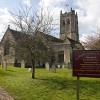
Portesham is a parish with a rich historical background, and further has responsibility for the hamlets and manors of Corton, Shilvinghampton and the Waddons. The Church of St. Peter already existed at the time of Domesday, though the Norman structure dates from the 12th century. Originally the chancel and nave may have been shorter, and the aisles further west than today. The chancel is 13th century and these are two blocked 12th century windows above the chancel arch. St. Peters was largely re-built in the 15th century. Indeed, it is the oldest building in the village. The lower part of the tower is Saxon, though traces of Norman work remain to be seen in the north wall of the nave and in the 13th century font. There is a 13th century piscina in the south aisle. The church is built in a limestone reflecting almost white in sunlight, with a well built, typically ‘Dorset’ tower incorporating the remains of an earlier tower on the north side.
As at Abbotsbury, the church and village suffered skirmishing during the Civil War, when some musket balls were discharged into the door of St. Peter’s, though these have since been removed. The interior is mainly re-ordered Victorian work. It displays the hatchment of Sir Andrew Riccard, a Portesham-born seaman and squire who was Lord of the Manor following the Restoration in 1660, and who granted many of his tenants 999 year leases. The inscription reads ‘Possum’ (I am able.) His father Walter Riccard is commemorated by a slab in the floor of the nave near the font. There are also memorial hatchments or plaques to members of the Mansfield and Thresher families, and to a former vicar, John Charles Molyneux.
Probably the most curious feature of the church is the grave of a local farmer, William Weare. Weare had the outlandish death wish of not wanting to be buried inside or outside the church. Accordingly he was buried beneath the wall of the south aisle in 1675, where a table-tomb and plaque mark the spot. The plaque bears an 8-line epitaph, which begins: “William Weare lies here in dust as thou and I and all men must…” There is a monument to Mary Weare inside the south aisle, abutting that of William. There is also a rough-hewn rock grave memorial to John Galpin, a former vicar, in the churchyard.
The principal commercial activity of the village of Langton Herring has been the production of lime, and the buildings are mainly constructed in the local yellow stone. The manor owns (or owned) a one-mile stretch of Chesil Beach. The Church of St. Peter is a building of local rubble with freestone dressings, possibly built or rebuilt in the 14th century. It is said to have been severely damaged in a fire in the 17th century, after which the west tower – one of the country’s smallest – was added in the 18th century. Major restoration also took place in 1827 & 1858. On these occasions the vestry and south aisle were added, and the nave was largely rebuilt with an arcade or two bays. The floor of the chancel features slab memorials to John Hazelwood, rector 1670 and his son Francis and William Sanford, rector in 1627. The font is an octagonal bowl with quatrefoil panel in each face, a stem with trefoil-headed panel in each face, and a stepped square base. In the chancel there is a stained glass window inscribed “In the Resurrection they are as the Angels of God.” There are memorials to Edward Cox Trenow (1851,) the son of a former rector who is buried with his wife in the churchyard, and to William Sparks who died in 1829 aged 70. The churchyard also contains the communal grave of four boys who were overcome by the fumes of a lime kiln they were playing near.
The original church of the small community of Fleet, only half a kilometre from The Fleet, is only one of the five to have just the chancel remaining after the rest of the church was severely damaged in a great storm in 1824. The manorial Lords were the Mohun’s, a family who came to England with William the Conqueror, and who are remembered in two brass plates in the chancel.
However, a new Holy Trinity with chancel, nave and west tower, was built a quarter of a mile further up the valley at the expense of the vicar George Gould, in memory of his son John who died in 1818. This church is built in the style of the 18th century Gothic Revival, though today the ashlars are reddened by lichen. In the tower there is a wall plaque recording the destruction of the first church and the building of the new. Its first stone was laid on the 25th of April 1827, and the Rev Robert Gray, the Bishop of Bristol consecrated the church, on the 25th of August 1829. Several beech trees grow in the grounds, which are fenced off by railings.
In the old church there is a brass memorial to John Meade Falkner, the author of Moonfleet. But it was in this churchyard, not Holy Trinity, that the John Trenchard of the story sat on a tombstone above the Mohun vault, where the smugglers hid their contraband.