One of the interesting, almost unique features of Dorset is a tradition of group-naming clusters of parishes after a spring or the stream valleys they occupy. Immediately coming to mind would be the dozen or so “Winterbornes” prefixing villages marking where a hillside spring dries up in winter. Another example is that of the Tarrant.
The Tarrant was first recorded as a stream under the Celtic name “Terente” in the 10th century, a word broadly translated as meaning “flooding river” or “trespasser” a variant of which recurs in the name Trent.
During the last glaciation some 10,000 years ago the Tarrant was probably part of a much more extensive drainage system fed by run-off melt-water from the western part of the chalk upland of Cranborne Chase in east Dorset. This water then cut a deep valley in which the Tarrant would flow much higher during heavy winter rainfall. This still occasionally happens today, with flooding of the road north of Stubhampton and Tarrant Gunville itself.
Because early man generally avoided the damp wooded Tarrant valley, little impact was made on the landscape until the 9th/10th centuries when Saxons settled the valley and made it a major focus of occupation. By Domesday all of the eight settlements to be prefixed “Tarrant” had appeared and thus were of sufficient importance to merit entry in this earliest of land registries. By the end of the 10th century six mills were in operation along the valley, though few traces of these survive today.
The Tarrant has been identified as having upper, middle and lower courses that collectively are of variable character. The infant stream rises as a winterborne in the western part of Cranborne Chase and this upper section occupies the valley between Stubhampton and Tarrant Launceston. From Tarrant Monkton to Tarrant Keynstone the river usually flows at its maximum height or constancy. From Keynstone the lower course then continues for a few miles to join the Stour a little downstream from Keyneston Mill, though oddly the water flow throughout this stretch is as susceptible as is the upper river to falling or even drying out completely during summer. This is believed to be the result of the Tarrant flowing over what hydrologists call a ‘perched water table’ some way above the main water table.
The upper course, which flows from a borne spring then directed into a stone-lined culvert near Stubhampton, descends the dip-slope of the chalk and flows south-eastwards past Gunville for a distance of about five miles. Throughout this stretch it flows through fertile farming country in which water meadows screened from the riverbank by thickets of alders pass upwards into arable fields on the chalk slopes.
Historian John Hutchins summed up the Tarrant country thus: “the down is rolling windswept chalk hills, many of them covered in a thin soil full of flints. The grasses are short and fine, so the traditional farming is sheep-rearing.” Since Hutchins times arable farming has largely superseded pasture, but his words still have some validity.
The valley profile is typically broad, and contains fertile loams. Near Monkton, where the Tarrant is crossed by a pristine white timber packhorse bridge, the river turns to the south-west and maintains this direction for the remainder of its course down to the Stour.
Of Stubhampton, the nearest settlement to the Tarrant-borne, there remains only a string of small farmsteads along the valley to testify to the fragmentation of a once more populous community.
Each of the eight Tarrants are notably settlements with their own distinctive character. Tarrant Gunville, the first T-group village the infant stream flows past, was once the location of Eastbury House, the finest of the county’s country mansions in its day. This residence was designed by the architect Vanbrugh for George Bubb Doddington, but after his death and that of his nephew three-quarters of this voluminous house were demolished in the 1770’s and 1780’s after becoming unwanted and falling derelict. Only the stable block, since converted into a private home, remains today.
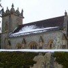
The stream actually flows beneath one of Eastbury’s gatehouses before continuing on its way for almost another mile towards Tarrant Hinton. This is a much-prized village of cob-walled thatched cottages clustered around the medieval St. Mary’s Church. Here also, the stream has been canalised in brick to direct it through a culvert under the Blandford to Salisbury road.
At Tarrant Launceston there is another packhorse bridge over the Tarrant, this time built with three arches in the 17th century, to link this village to Monkton. A little way downstream from this bridge the course of the river convulses into a sequence of neat filigree meanders flowing through meadows. Near this point too, is The Cliff, a harder, more resistant band in the chalk which commands a fine north-facing lookout point for the valley. From here one can see the gradation of land use in the valley: from the half-concealed Tarrants, across the arable downland and pasture to the distant royal hunting woodlands of The Chase.
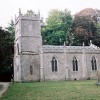
The Tarrant next reaches and passes Rawston where the restored church, now a private chapel, is sheltered by a fine brick and greensand farm. Near to the bridge serving Rawston Farm the river plunges over a weir close to a miniature waterwheel in a brick wheelhouse, and from this point onward a more constant spring flow has favoured a proliferation in the river’s trout population. Nearby stands Tarrant Rushton, a village of cottage homes built in a linear uniformity just above the flood level.
After passing beneath another busy road the Tarrant then reaches Keyneston, probably the most vibrant of the Tarrants, home of The True Lovers Knot pub and All Saints Church built upon higher ground to the north. In the graveyard of this church lies the Fontmell-born author and former Head of Cassells, Sir Newman Flower, who made his retirement home in this village up until his death in 1964.
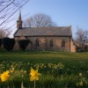
The lowest part of the Tarrant valley is said to have an air of mystique about it. Here the valley road diverges from the river where it flows past Tarrant Abbey Farm, once the site of a Cistercian nunnery. Near this point on the south side stands the lowermost gem of the Tarrant valley: the Church of St. Mary, featuring preserved medieval wall paintings. The river then flows past the vineyard of Keyneston Mill before discharging its waters into the Stour amid a thicket of willow and alder. This tree-shaded confluence has something of the secluded nature of the Tarrant’s birthplace in the dry chalk upland of Cranborne Chase.
For about thirty years now flow levels in the Tarrant have generally been in decline. The abstraction of water from boreholes at Stubhampton and Shapwick by Wessex Water has been suggested as a possible cause of the fall in the river’s water table over this period. One hydrologist has reported that although the Stubhampton borehole is unlikely to have caused the low flow in the upper Tarrant, the borehole at Shapwick may well contribute to the drying out of the lower Tarrant. Yet much pleasure is still to be derived from tracing this ancient chalk waterway’s journey to the sea.