One interesting aspect of studying towns is how the local geology can so often influence their development. This can be expressed either in topographical terms or in economic terms (such as earth resources providing the raw materials for certain industries.) Dorset furnishes us with a quite unique example in the pair of towns marking the extreme western and eastern ends of the county along the south coast. Lyme Regis and Christchurch could be regarded as the county’s bookends, though they are very different in character. And this distinction can be explained as a reflection of the stark contrasts in the nature of their terrains, or geology of their environments.
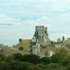
Lyme’s position in the west of the county has always meant that its growth has been subject to some restraint because of the hilly nature of that part of Dorset. The precipitous relief is mainly due to the presence of the hard Liassic limestone of the Jurassic period, which underlies and encompasses the town. Indeed, the road running north-west in and out of Lyme has a mean gradient of about 1 in 3 and takes several sharp turns to avoid even steeper slopes.
On the other hand, Christchurch has grown up within the much more open and gentler terrain of east Dorset, underlain by much younger and softer sands and clays of the Tertiary era. This area if not one of steep hills, valleys and coombes, but of a flatter landscape giving rise to marsh, water meadows and the infertile acid heathland extending behind Bournemouth and Poole and into the Isle of Purbeck. Settlement here therefore has never experienced the topographical restraints of the west and so easy communications and access have given free reign to the growth of Christchurch as a populous resort.
Lyme Regis and Christchurch have of course a seaside situation in common and both are, for that reason, unable to expand southwards. But whereas there are no obvious or insurmountable barriers to the growth of Christchurch in the other three directions, this is not so for Lyme. Today this town is a Mecca for tourism of a predominantly thematic nature, a specialisation which has more to do with what the local rocks contain than with any difficulty of access their topographical expression may present.
The Liassic strata which outcrops in the west Dorset cliffs literally teems with thousands of fossils, principally the remains of ammonites and marine reptiles. These vestiges of Dorset’s remotest antiquity have made Lyme a honeypot for scientists and fossil collectors for over 300 years, and today the damage and erosion arising from this intensity of casual collecting is greater than ever. Because of this immensely important resource for scientific enquiry, the cliffs at Black Ven and Charmouth near Lyme form the western extremity of the internationally important Heritage (or Jurassic) Coast SSSI. This makes the town effectively Britain’s, if not the world’s capital of ‘fossil tourism.’
Yet it is these same cliffs which are impacting on Lyme’s prospects for growth in other ways. The hard limestone bands throughout the Lias deposit which are responsible for enclosing the town with steep slopes are interspersed with soft unconsolidated clays which, when waterlogged, can easily propagate landslides. Landslips, particularly the major Downlands slip of 1839 are clearly in evidence along the urban shoreline and such is their instability that they cannot be built upon, so constricting any development eastwards and westwards, as well as to the north. In addition, sea quarrying of the Lias Ledges in the early 19th century contributed yet more to the damage of the coastal sections.
As might be expected in a hill-rimmed coastal situation, evidence of Lyme’s prehistoric past is scanty. Some New Stone Age artefacts from around 3,500 BC have been found locally, and the Romans built a villa at nearby Holcombe to be closely associated with their road (now part of the A35.) The first documented reference to Lyme is from 744, referring to a manor and salt rights. Following an initial prosperity as a medieval market and trading port, it suffered a near catastrophic recession, contraction, and de-population from the mid 17th to the early 19th century, when it recovered, through the Victorian fashion for bathing and drinking seawater. Today the town is a fashionable retirement centre, where visitors and incomers regularly outnumber the long-established population by four or five to one.
One peculiarity of the old town – seen in Coombe Street – does owe its origin directly to the serious shortage of land and cramped site conditions in the borough. This is a drangway or narrow public passage giving access to courts or cottages behind, and has encouraged much of the haphazard planning favoured by modern landscape architects. It is also significant that Lyme was inaccessible to wheeled traffic until the opening of the turnpike road in 1759.
By contrast, Christchurch is in a very different league. Here there are no high cliffs or hills sheltering the town from inland. The soft underlying tertiary strata is poorly exposed and lacks the spectacular fossils of the kind that would arrest the interest of the casual collector. Instead, the town has grown up in the midst of extensive marsh and water meadows created by confluence of the Stour and Avon, which form a natural, though not inexceedable, boundary to the borough.
Not surprisingly, evidence of prehistoric settlement at this site is far richer than at Lyme and includes Old, Middle and New Stone Age implements extending back at least 12,000 years. There are also indications that the harbour was already in use as a port facility in prehistoric times. On the south side of the harbour is the promontory of Hengistbury Head, a further very significant site of early prehistoric activity. Here on this headland of grasses and bushes growing in orange-yellow sands prehistoric people constructed a double dyke across the neck of the promontory and appear to have operated a crude flint-tool industry, leaving their wasters for today’s archaeologists to find.
Just as Christchurch is richer in archaeology, so accordingly is it in the raw resources for home grown industries. For instance, on the eastern slopes of Hengistbury Head the sands contain a formation of ironstone in the form of ‘doggers’ formerly quarried and sent to Beaulieu to be smelted into iron fittings for naval ships. Removal of many of the Hengistbury doggers and boulders from the foreshore however, encouraged a problem of coastal erosion until quarrying ceased once it became unprofitable. The now abandoned ironstone pit has been flooded to create a scenic wildlife lake.
The configuration of its coastline and the presence of a long harbour also made Christchurch as favourable to 18th and 19th century smugglers as Lyme, and fishing was still important in the 19th century, as was working on the land, brewing, glove-making, hosiery and making watch chains.
The two rivers of the Frome and Avon have provided water-power for driving mill wheels, and are also noted for their salmon catches and farms. The absence of prominent hills makes the district favourable for aviation, as at nearby Hurn airport.