Knowlton is a deserted village hamlet on the B3078 in the east Dorset parish of Woodlands, 10 miles north of Wimborne. The motorist passing speedily through the place on the main road may notice nothing more than a number of low mounds and embankments, which may convey nothing to the untrained eye. Seen from an aircraft or balloon however, and the full extent of an amazing complex of earthworks will be immediately apparent, ideally in the low, raking sunlight of evening.
The ancient structures scattered across nine fields at this site are the funeral and ceremonial monuments of Neolithic and Bronze Age communities occupying this area from about four and half thousand years ago. Possibly the locality was favoured for the fertility of its soil and/or the proximity of a stream for water supply. But the sheer density of the earthworks, indicate a very long phase of occupation spanning over a millennium. There is not just a scatter of a few graves at Knowlton, but a complex of memorials on the scale of necropolis. Indeed, it has been said that in their day these earthworks ranked only third to the great megaliths of Stonehenge and Avebury.
Central to this complex of prehistoric remains is a close-knit scatter of four of the ring-bank and ditch enclosures known as henges. These structures diminish in diameter from south to north and are ramified by the course of the B3078 and a minor road running northwest from it. The main road actually bisects the Southern Henge which, with a diameter of 220 metres, is the largest enclosure in the group. In the angle thus formed by the main and unclassified roads are three other henges: the central but smaller Church Henge and, 100 metres to the north-west, the still smaller Northern Henge and the tiny enclosure known as Old Churchyard.
Approximately equi-distant from the henge complex to the northeast and southwest are two dense scatters of round-barrow mounds, and known respectively as the Northern and Southern Barrow Cemeteries. A further ten barrows have been identified and plotted with a random distribution among the henges, with another four in an imperfect east-west alignment across four fields slightly to the west. One dominant barrow (Great Barrow) with an unusually distant ditch lies 50 metres east of the Church Henge. These barrows vary widely in size and represent higher caste burials of the Bronze Age Wessex Culture, dating from a later period than the ritual henges of the Neolithic settlers. The barrows now mapped at this site now number about 55.
Clearly the reconstruction and interpretation of this site would represent archaeological bodies with a challenging source of material for investigation. So it was that in 1993 landowner Arthur Thomlinson and a confederation of other local landowners granted permission for a programme of surveys and excavations to be conducted by Bournemouth University with funding from English Heritage. The results of these investigations added considerably to the knowledge of the site in general and Southern Henge in particular.
Unlike other types of circular enclosures, henges are defined as having the corresponding ditch on the inside, not the outside of the bank. It was the Southern Henge upon which the attention of the BU archaeology unit was primarily focussed, with a preliminary geophysical survey of a cross-section of the bank and ditch on the south east side being carried out. However, the result was inconclusive, as the bank of the henge did not respond well to the survey techniques. For the 1994 season the following year the university project team excavated a 3 by 30 metre trench across the area surveyed the year before to access the extent of plough damage and to examine in more detail the earthwork’s stratigraphy. It was found that the henge bank survived to a depth of only 20 centimetres and had indeed been extensively damaged by ploughing. A burial soil was also discovered beneath undisturbed portions. The ditch, which is separated from the bank by a 9.5 metre platform, was 5.5 metres deep, though only 4.5 metres could be excavated at the time.
The ditch fills suggested that it had been cut with almost vertical sides, and there was evidence of episodes of slumping. Two slot-trenches were also found one with posts and the other with wattle work. On the floor of the post trench a piece of worked chalk was discovered.
Elsewhere, this season saw a geophysical survey being conducted over the north-east quadrant of the Southern henge, where aerial photography had indicated past entranceways, now possibly obscured by the main road or farm buildings. A contour survey was also carried out over the eastern half of the henge and another geophysical survey was undertaken of an area to the south where some ring-ditches had been identified. One of these was a double ring-ditch 29 metres across, while the others formed a tight cluster; one large ditch was cut by smaller examples.
Following the arrival of Christianity in Britain, a popular practise was to consecrate and thereby perpetuate henges and other prehistoric enclosures as holy, ritualistic sites by building some of the earliest churches within them. In so doing it was likely thought by the early ecclesiastics that they were symbolising the triumph of Christianity over paganism, whether or not the sites were foci of some kind of tellurian energy which could be tapped for religious purposes. Normally however, evidence of the maintained use of a prehistoric ceremonial site by the Christian priesthood will have been obscured by trees, boundary demarcations, etc, such that unusually circular churchyards in areas of prehistoric settlement may be all that is visible to betray the practice today.
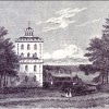
But as a consequence of unusual circumstances, this was not the fate of the Church Henge at Knowlton. This monument is probably unique, for no-where else in England, if not the UK, can one see a better example of the heathen-to-Christian transition in its bare native state, for this church was never walled or consecrated for burials. And this enclosure may have been sacred to Celts, Romans, and Saxons before the Norman’s built a stone flint-rendered church here sometime in the 12th century.
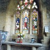
Records state that this church had once been a ‘Chapel of Ease’ for Horton, was enlarged during the 15th century, and had a curate (Richard Saunders) in 1550, when there were three bells in the tower. But it is likely that the effects of the mediaeval plagues, which led to the de-population of the village, also affected the church, and in about 1650 regular services ceased. After a brief period of restoration and revival, the church was abandoned after a roof collapse some time later. The font was removed to Woodlands Church.
Today the empty shell of this church stands within the henge approximately 300 yards from the deserted village. This henge is about 100 yards in diameter and became the focus of attention from the archaeology team for their 1995 season. At this time a contour survey of Church Henge was conducted, the results suggesting that the bank around the west entrance (one of three) had been altered after the henge’s construction, possibly when the church was built. Other evidence led to the supposition that the northeast entrance of the henge may have been created some time after, by infilling the ditch at that point and removing a portion of the bank.
1995 also saw the University students surveying the northern henge and Old Churchyard. Northern Henge is a curious earthwork consisting of a sub-rectangular ditch enclosed within a horseshoe-shaped bank, both of which are broadly open to the southeast. Old Churchyard, the smallest of the four enclosures at Knowlton, is even more unconventional, having a small squarish bank enclosed by a circular 60-metre diameter ditch with one entrance on the northeast side. This configuration and small scale is difficult to parallel, and has no precedent among the classes of ringed earthworks known. Furthermore, the feature does not conform to a henge in the strict sense, since here the bank-ditch positioning is reversed. However the finding of scatters of burnt flint in the vicinity of the enclosure clearly points to a prehistoric origin, and contemporaneous with the true henges. It has been thought this feature could signify a valuable link between earlier and later Neolithic monument methods and styles.
An analysis of the molluscan (snail) profiles in the ditch of the Southern Henge revealed that considerable change during use and decline of the monument had taken place. One other feature of the site identified by aerial photography and the University research was an as yet undated track way leading off southwest across a large field from the south side of the Southern Henge. This may be Medieval, but it is yet another controversial element in the complex history and remarkable sequence of human activity at Knowlton.