Dorset Ancestors Rotating Header Image

The Parish Church of St.Mary at Iwerne Minster

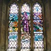
In an earlier article we discussed the village and parish of Iwerne Minster; now it is time to look at the parish church. Pevsner claims it to be “…The most important and interesting church in the neighbourhood…”, and Simon Jenkins includes it in his book ‘England’s Thousand Best Churches’ and he recommends we take our Pevsner with us. So here we are with our well thumbed copy in hand.

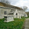
This Norman church dedicated to St. Mary was built on a slight rise towards the eastern part of the village and possibly over an earlier structure. Work started in about 1100 AD when the quarrymen and masons were drafted-in. The workmen would have lived in the village for some years during the build. Much of their original work survives, bearing witness to their skills. Take special note of the pillars of the nave arcades with scalloped capitals, the depressed church arch, the north chapel with its pair of narrow deeply splayed windows, the round arches of the north aisle and its west window, all the work of these early craftsmen. The transitional pointed arches of the south aisle may be of the same date. Conveniently, at the time the church was being built there was a quarry directly opposite the site, but it has long since been filled-in.

The walls of St. Mary’s are of flint and rubble with ashlar dressings; the roofs are stone-slated and tiled. The nave, north aisle and north transept are of the mid 12th century and, says the RCHM, “they appear to be parts of an important church”. It is thought the original church was cruciform in plan and probably had a south tower. Late in the 12th century the south aisle was added on the west of the presumed south tower. Early in the 13th century the north transept was rebuilt. The chancel, west tower, south and west walls of the south aisle and the south porch are all of the 14th century. The tower is 60 feet in height, buttressed on three sides and crowned by a battlemented parapet. William of Wykeham was a great builder of churches and in 1361 was prebend for Iwerne in Shaftesbury Abbey. It is thought he may have promoted the building of the tower.

In the 15th century the chancel arch was widened and a steeple was added to the west tower – a rarity for Dorset. The nave was heightened during the 16th century and clerestory windows were installed.

In 1807 Thomas Harvey and Christopher Senior made extensive alterations to the church, which were not universally appreciated and in some quarters referred to as “mutilation rather than restoration”. We know that Thomas Harvey was a churchwarden. The steeple was cut down in size: originally it rose 40 feet above the tower but was reduced to about half that. The steeple is octagonal, with ribbed angles and has two traceried bands around it; a finial and a weather vane complete it. The rood loft, said to have been the most perfect in the county, was removed along with the steps leading to it and a deep gallery was put up across the tower arch at the bottom of the nave.

Then in 1871 T.H. Wyatt, a well known church architect who had built and restored many churches, was brought in to restore the church. He removed the gallery and replaced the old high pews with pitchpine seating, at the time considered fashionable. A squint was opened up in the north chapel and a north vestry was added. The south chapel was added in 1890. It is a memorial to Lord Wolveton by his widow.

There are six bells, the oldest, early 14th century, bears a fine Lombardic inscription “HVIC ECCLESIE DEDIT TERCIA SIT BONA SUB JESV SUB NOMINA SONA”. Three bells were added early in the 17th century, suggesting wealth as well as piety in the village; they are dated 1609,1613 and 1618. A further bell was added in 1768 and is inscribed: Mr Thomas Harvey & Mr John Applin, wardens. Another bell was raised into the tower on the coronation of King Edward VII.

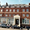
There are many monuments and floor slabs in the church including: Robert Fry, his wife Mary (Cox) and other family members 1684; John Ridout 1764 and his wife Henrietta 1730; Katherine wife of Francis Melmouth 1718;  Mrs Bower 1721; Thomas Bower 1728; John Bower 1711. The Bower family held Iwerne Minster House and estate for about 250 years before selling it in 1876 to George Glyn, 2nd Baron Wolveton.

‘Tapper’ Toms (1854 – 1924)

Henry Thomas Toms grew up to be one of life’s characters. He was known as Harry Toms and later in life acquired the nickname of “Tapper”. Some thought he was a little eccentric; certainly he was one of those old-time independently minded individuals with curious ways we rarely see in our villages today.

He was the son of William Toms, a thatcher from West Lulworth who went to Winfrith Newburgh, a neighbouring village to find a wife. He married Mary Roberts at St. Christopher’s church, Winfrith, on the 8th of October 1833.

William took his bride home to Lulworth and on the 25th of May 1834 their first child Henry was baptised at Holy Trinity Church at West Lulworth. A further ten children would follow: John in 1836, Martha in 1837, Mary in 1838, Joseph in 1841, George in 1843, Sarah in 1846, Jane in 1848, Fanny in 1851.  We have not carried out a forensic examination of the family history but it appears the first child Henry and the second child Martha died in infancy and we believe Fanny died aged about 6 years.

Then in 1854 William and Mary had another child they named Henry Thomas. Mary probably thought her days of nursing children were over but she would have been mistaken, because six years later at the age of 45 she again found herself pregnant and in due time a further son, Walter George, arrived. In 1871 Mary Toms then 56 years of age and a widow for these past six years was living in West Lulworth with her sons 16 years-old Henry Thomas and 11 year-old Walter George. Mary passed away in 1880.

Harry Toms worked as a general and sometimes agricultural labourer. It was the custom in those days to lay a neat hedge, but not Harry, who excused his work by saying “I don’t hold wi’ trimming hedge sticks, a good rough hedge ‘ull kip out cows”. Not surprising then, that he was not always fully employed and his work was said to be “average”, perhaps the result of losing his father at a young age before he could learn his father’s trade.

When trimming hedges he always found a walking stick to add to his collection, each stick had a ‘frost’ nail driven into the end of it to prevent slipping. He always used a stick and the noise of the nail on the hard road earned him his nickname – “Tapper”.

He was a man of regular habits and idiosyncrasies. Nightly he would “tap” his way to the Red Lion Inn at Winfrith where he would enjoy some ale and a smoke before setting-off home again, always leaving at 9 p.m. “Tapper”, we are told, never bathed and was often “itchy” and people got used to seeing him rubbing his back against a post. When summer came he would “tap” his way to the sea to wash his shirt, which he would wring out as dry as he could and then put it back on, it was dry by the time he got home. He believed sea water would not give anyone a cold and surprisingly he was always healthy. He told the time by the trains (try doing that today!). People described him as an interesting talker often using words that had long passed out of fashion.

In his later years he was employed on the farm of Mr. George Atwil at Winfrith and he made his home in an empty cow stall. It seems “Tapper” never slept in a bed or ate his meals from a table and he refused both when offered by Mr. Atwil. He would collect his meals from the farmhouse and ate in his cow stall and when he turned-in for the night he would remove his boots and sleep fully clothed covered with old coats in the feeding trough. It seems there was not a woman in Lulworth, Winfrith or Owermoigne who would entertain the prospect of taking  “Tapper” for a husband.

We know “Tapper” was working at Atwil’s farm until at least 1916. When he became too old to work he was taken to the Workhouse at Wareham where he died in 1924. He was described as a “queer looking man, short, wiry, rather humped-backed, with busy eyebrows that overhung his sharp little eyes, and a ginger beard, and he wore a trilby hat with its crown always pushed up”.

Horton – A Folly for a Man with a View

To some it is an interesting folly; to others it is a blot on the landscape and to a telecommunications company it is a very convenient perch for their mobile phone aerials. To its builder it was a seat from which he could watch the hunt when he was too old to ride to hounds himself or gaze up at the heavens. We are talking about Horton Tower or, as its builder liked to refer to it, Horton Observatory.

Pevsner  describes the builder as a “megalomaniac” and before you  accuse the old man of going over the top just remember the same builder was responsible for submerging the village of Moor Crichel just so he could have a lake in his front garden.

The man who wanted a room with a view was Sir Humphrey Sturt. He was born in 1725 and doesn’t seem to have wasted a moment of his six decades; he died on the 20th October 1786. He was the son of Humphrey Sturt of Horton and Diana Napier. On the 27th of April 1756 at St. James, Westminster, he married Mary Pitfield the daughter of Charles Pitfield and Dorothy Ashley; it is through his wife he inherited Moor Crichel. The family wealth came from his grandfather, Sir Anthony Sturt, a businessman, City of London Alderman, and a victualler to the Navy. 

Elsewhere he has been described as “energetic, ambitious and wealthy”  – and to this we would add visionary. He had many ideas for improving agriculture that were ahead of the times and he introduced them in the Crichels and on Brownsea Island, which he bought in 1765. He used steam power for threshing and records suggest he spent £50,000 improving the castle and gardens on Brownsea and bringing enormous quantities of manure to the island where he planted several new crops. He was an architect and the MP for Dorset between 1745 and his death in 1786.

Sturt’s Tower sits in open country a little outside of Horton village. Its six storeys with brick walls rise 140 feet above the ground and originally there was a fireplace half way up it. Above the fourth storey the straight sides have classical pediments and the round turrets have ogee domes, with ball finials; all openings have two-centred heads. The woodwork has gone but there are beam-holes for six floors which Pevsner thought would allow for up to eighteen rooms.

This folly was used as the location for the cock-fighting scene in John Schlesinger’s film version of Hardy’s Far From the Madding Crowd . Love it or hate it you cannot miss Horton Tower – it can be seen from miles around.

We have posted a photo of the tower in the photo section.

Dorset Home to the Development of Radar

It would not be an exaggeration to say that Dorset played an irreplaceable part in overcoming the Nazi threat in the 1940’s, and in the preservation of freedom for the world. Not far from Corfe Castle, where for centuries events were played out which are part of our history, on the seaward side of the Isle of Purbeck is where for two years the sciences behind electronic defence, attack and navigation were worked out.

Today, through radio technology we can watch events on the other side of the world as they happen, and view missions to the moon or Mars, and it can all be traced back to Worth Matravers and St.Aldhelm’s Head, on the Dorset coast, not forgetting earlier as well as later research locations elsewhere. Four miles from Swanage, in the early days of the Second World War, a vast radar experimental complex was set up, which was to draw Service and scientific personnel and leading electronic engineers from all parts of Britain. The inventors moved in, academics mixed with mechanics – and it was all hushed up.

From their researches came, perhaps most notably, blind bombing by an amazing new system code-named ‘H2S.’ Later, the Aircraft to Surface Vessel technique was developed to pinpoint U-boats as they hunted in packs for shipping from North America carrying the vital supplies which kept Britain going – one of the greatest threats to our survival – as well as armaments for D-Day and the conquest of continental Europe.

Even the microwave oven owes much to the Isle of Purbeck, although the idea of the cavity magnetron, which was to be used in wartime as a transmitting valve creating echoes, came from two research workers at Birmingham University – John Randall and Harry Boot. Fundamentally, they were the ones who made Worth Matravers famous. Some would say the magnetron won the war.

Microwave links for telecommunications and television have much to thank Dorset for. So have weather forecasting by radar, and navigational aids. Computers came later. Long before the war, though, with Hitler seeking world domination, defence strategies involving radar began to be developed from the mid-1930’s and a chain of early warning stations with tall masts was built all down the east coast and as far west as the Isle of Wight.

With the research station established, the small airfield at Christchurch further along the coast towards Southampton was in use for 18 months by aircraft testing the devices. The aim was to create equipment that would show echoes from the ground or from the sea aboard Allied ‘planes. Sometimes a target aircraft would fly above Swanage Bay, towards or in line with the coast so that its image could be picked up on a screen on the shore.

Reg Batt, in his book ‘The Radar Army,’ relates how echoes were first received at Worth Matravers from a coastguard hut and the chapel of St.Aldhelm, on the headland. The old chapel is now the only vestige of the research station that still exists.

But a moving target was required, so one day he set out along the headland on his bicycle, apparently on his own initiative, with a sheet of metal wired to his machine. This was to lead to exciting results on the screen. They were getting somewhere. But their big task was to reduce the wavelength they used to a few centimetres for clarity, which had never been done before, and to site the equipment they invented aboard an aircraft.

The best brains from the universities, including (Sir) Bernard Lovell, later the inventor of the Jodrell Bank radio telescope, were brought in to get the best results. All this led to the perfection of radio beams and blind bombing with the use of the magnetron valve, so that darkness or poor visibility presented no problem at all in marking the target.
 
Not only ‘H2S.’ but other techniques such as OBOE and GEE were developed in Dorset too. All were vital to defence, navigation and attack. Secret experiments were made with crystal and klystron, where Britain co-operated with the United States, and which was a pulse transmitter of less power than the magnetron. High-powered parties from London and abroad visited the site.

Eventually 17th century Leeson House in Swanage was to be taken over by the research station, which was an easy target with its high masts that could be sighted far out to sea. The position was very advantageous, however, and there was great excitement when distant points such as the Needles and St.Catherine’s Head, 32 miles away, were picked up.

Meanwhile, manufacturers across the country were ready to put the new creations into large-scale production for installation. Giant aerial systems involving dishes looked out on Swanage Bay, a factory production unit sprouted in north Bournemouth, and then came the day when Telecommunications Flying Unit at Christchurch was promoted and moved to a new airfield at Hurn, which was one day to become Bournemouth Airport.

In early 1942 the whole of the Worth Matravers complex moved in to Malvern College, as it was assumed to be under possible threat from commando attack. Defford Airfield in Worcestershire became the associated flying unit housing a large number of test aircraft.

It meant an upheaval for 800 personnel and in some cases their families. The seaside town of Swanage, where many of them had lived, became a quiet Dorset community once again. Masts had to be dismantled and crates packed and as many as 90 removal vans and flatbed trucks would be on the move out of the Isle of Purbeck in one day. As for the workers, they packed their things and left in fleets of coaches brought from all over the area. The move was accomplished in three weeks.

Some of the aircraft flying out of Defford, which included heavy bombers such as Lancasters, Halifaxes and Super-Fortresses, were quick to pick up echoes from the shores of the Bristol Channel, Chepstow and the River Wye. The nearest large towns of Gloucester and Cheltenham were seen almost as on a map. Meanwhile, down below, as in Dorset, the people went about their business completely ignorant of the experiments being conducted in the skies above them.

A terrible tragedy struck in June 1942, when a Halifax heavy bomber crashed in flames in the Forest of Dean, carrying all 11 RAF and scientific personnel on board to their deaths, including A.D. Blumlein, who has been called the foremost electronic engineer in Britain at that time, and who advised the type of television system adopted by the BBC in 1936 rather than the Baird system.

Prime Minister (Sir) Winston Churchill immediately ordered a redoubling of efforts on ‘H2S’ research, and some three years after the principle was discovered the cavity magnetron was installed in many of the RAF’s aircraft by the following year, as well as in U.S. Air Force aircraft. The national radar memorial window was erected in Goodrich Castle, two miles from the Halifax crash scene, in the 1990’s.

While it functioned in close association with Worth Matravers, the airfield at Christchurch, whose runway was only just long enough for the Boeing airliner shipped over from the United States, and which had been adapted as a flying test bed, was Top Secret and had its own uniformed Air Ministry police force.

What a change, and what an upheaval, came over these sedate Dorset towns (although Christchurch was then in Hampshire,) in the early years of the war; then the busy scene changed and the action moved elsewhere. Working conditions were often primitive and without heating.

Yet everyone pulled together, no secrets appear to have been divulged, and in a few years the war had been won, on the Continent, in the Atlantic, in Africa and the Far East. It is difficult to see how it could have been without radar, in which Britain took the world lead. Without that, and the part that Dorset played, world history would be very different from what we know today.

Collision off Portland – 1877

This was a night when gale force winds lashed the Jurassic cliffs of Dorset’s coastline, a night when the sea thundered ashore on Dorset’s beaches, and a night when lifeboats saw action but still there were vessels lost and numerous casualties. Furthermore, this was a night when many seafarers sailed their last voyage. And it was a night when the decision to head for shelter or go bare masted into the storm would be critical – and a night when good Captains earned their rank.

Storms ushered in September of 1877 and for seafarers in the waters off the Dorset coast the nights of September 10th and 11th were very difficult.  A French fishing vessel crashed aground on Chesil Beach, all hands lost. Many local Chesil fishing boats were smashed up on the beach. But the biggest loss came as two large vessels both at the start of long deep sea voyages out of London collided off Portland. 

Ploughing down the Channel and in the charge of a pilot was the iron ship Avalanche, her Captain, E. Williams was well thought of by his ship’s owners, Shaw, Savill and Company. He was a seaman of great experience: he and his ship were much favoured by colonists who regularly visited or traded with England. The crew and officers numbered thirty four, to which could be added a steward and twelve foreign seamen along with emigrants and other passengers making a total of about one hundred souls on board the Avalanche, which was headed for New Zealand. Built three years earlier, the ship was rated A1 at Lloyds and was of some 1,000 tons.

The wooden ship Forest of Windsor bound for Sandy Hook near New York in ballast, had departed London at about the same time as the Avalanche. The ship, about 200 ft and nearly 1,500 tons, was built at Windsor, Nova Scotia in 1873; she was owned by Churchill and Sons and was also registered A1 at Lloyds. Her master was Captain Ephraim Lockheart.

On September 10th the wind backed, blowing strongly from the south-west causing huge seas in the Race off Portland. The following evening, with the tide under her, Avalanche sailed close in to Portland Bill in an attempt to steer clear of the tremendous seas churned up by the Race. Rain kept her from the view of the lighthouse-keepers and others watching the sea from the shore.

Captain Lockheart on the Forest of Windsor had been leading his hard stretched crew of just twenty-one men continuously through the turbulent seas encountered during the passage down the Channel. He caught only a glimpse of the cliffs off Portland through the rain. Both vessels hidden from each other by a wall of rain were racing through this turbulent vortex of water, their masters unknowingly heading directly towards each other. 

At half-past nine on the evening of Tuesday, September 11th with no warning, the Forest of Windsor suddenly tore into Avalanche. The ship foundered and all her crew and passengers were lost to the sea within minutes with the exception of the Third Officer, John Sherrington, and two seamen who against all the odds stacked against them managed to get on board the Forest of Windsor. Two emigrant families with ten children between them were amongst those lost.

The Forest of Windsor began to fill with water but remained upright long enough for attempts to be made to launch her boats. Violent squalls of wind and high seas swamped four of the boats but one, manned by Captain Lockheart, his chief mate and John Sherrington from the Avalanche, and nine others was able to get away before the Forest of Windsor capsized.

Peculiar to the Portland area is a fishing boat known as a lerret. Not only is it a good sea boat but has some characteristics of a surf boat which enable it to land through the surf onto Chesil Beach. It was to their lerrets that early on Wednesday morning, several brave Portland fishermen ran. J. Chaddick, John and Tom Way, Tom Pearce, Tom and Lew White and John Flann to one boat and to another went another Flann, another John Way, G. White, Bennett, and J and G Byatt. Later the bravery of all these men was recognised by the Agent General of New Zealand, who sent them all a payment of £5 matching an award made to them by the Board of Trade. A further £130 was collected and handed to the men later in the year.

For several days bodies of the drowned washed ashore on to Chesil Beach and at Portland, Chickerwell and Abbotsbury. The Jury at the Coroner’s Inquest held at Portland on September 15th expressed dismay at the “neglect to provide decently for the interment of the drowned.”

The upturned hull of the Forest of Windsor showed no inclination to sink; it was a hazard to shipping and the Royal Navy ordered H.M.S. Defence under the command of Captain Howard, aided by H.M.S. Black Prince and H.M.S. Galatea to sink the wreck. The Navy attempted to blow the wreck out of the water using torpedoes but these just ran through the wreck. Over the following three weeks it shrugged off gunpowder charges, mines and all sorts of means, stubbornly remaining unmoved. As if to mock its attackers after one assult the lid of a seaman’s chest floated to the surface decorated with a picture of the Forest of Windsor in full sail. The demolition of the wreck was finally accomplished three and a half weeks after the collision at a cost of about £1,000.

There is an illustration of the rescue in the photo gallery.

Lord Denzil Holles

Three hundred and fifty years ago, one of the great men of Dorset championed the Parliamentary cause and was one of its leaders in the Civil Wars during a political career that lasted nearly 60 years.

He was Lord Denzil Holles, second son of a gentleman. He lived from 1598 to 1679. Eighty-one years is a long life in volatile times such as he lived in, one of the climactic periods of Britain’s history.

His oldest brother inherited the family lands and he had to make his own way. But he was still one of the favoured aristocracy, and the family motto was “ Hope favours the bold.” He could hardly lose. However, life was hard even for the landed classes and medical attention was still in its early stages. His mother Anne, wife of the Earl of Clare bore 10 children and he was one of only three survivors.

He was bound for a life in the political arena, and his presence in the House of Commons was first widely noticed in 1629 at the age of 31. Three years earlier he married Dorothy, daughter of Sir Francis Ashley. They had four sons, of whom only one survived. The family was very much bound up with Dorchester and the surrounding county. Most of Holles’ estates were in Dorset. He was made a freeman and burgess of Dorchester. Yet he is somewhat forgotten today.

His time at Westminster did not pass easily. A man of temper when roused, he was in January 1642 one of five MP’s charged with high treason, possibly because of correspondence with the Scots. He was against episcopacy at a time when the Scottish bishops refused to give way to moderate views, and he went along with the Presbyterians.

Involving himself in the military preparations for the Civil Wars, he helped to set up a regiment of foot soldiers which left London with the Earl of Essex’’ army in 1643. But politics had taught him a lot. Within a few months of the outbreak of war, he became a supporter of peace with the King, and by 1648 the Royalists even saw him as ‘one of themselves.’

In 1647 he led the House of Commons but later had to escape to France. Fifteen years later King Charles II was to appoint him as ambassador to that country. It is said that throughout his life he showed concern for matters of honour and justice.

There is a memorial to Lord Holles in St. Peter’s Church, in the centre of Dorchester.

Chalbury Church

In eastern Dorset, in the Cranborne Chase country near the Wilts and Hants border lies the barely registered hamlet of Chalbury. There has been a church here at least since the early 13th century, but one, which was never dedicated to any saint. It did not serve a community with a definitive nucleation around a green with cottages, shops, or an inn, but instead just a few dispersed dwellings clustered around the base of the low, though steep hill the church stands upon. But the building never underwent the development accretions that so many other churches in more prosperous parishes did.

This is clearly evident from the exterior appearance of Chalbury Church. To this day it remains a rustic memorial to a bygone society, way down on the scale of ecclesiastical architecture and appearing to show the hallmarks of a stagnant economy in the community it was built to minister to. This church still shows a simple nave – chancel plan, to which aisles, transepts or a tower were never added at a later stage. Instead the visitor is confronted by a long narrow building scarcely wider than a cottage, with only a south porch and a diminutive cubical bell-cote at the west end to summon the few faithful to worship through the tolling of its single bell.

Chalbury further departs from  the customary appearance of churches in the more prosperous Dorset parishes by having a smooth whitewashed surface, as distinctive from the commonplace unadorned, frequently lichen-infested brick, stone and flint courses so evident elsewhere. Round-headed windows of only clear lights are set into the walls and the roof is of small, neat tiles, with a small skylight near the west end on the south side.

The appearance of the interior, as one might expect, is as unusual and unique as the outward aspect of this church. It is whitewashed, with a smooth corbelled ceiling below which some dark oak beams span the width of the nave. The original arch between the nave and chancel has been converted into a tripartite screen with a segmental-headed centre section with two straight-headed sections supported by classical columns on either side. It is several feet deep, so there is the effect of a short colonnade as well as screen.

This feature, as well as the interior details in general, is due to a re-ordering the church underwent in the 18th century, at which time also the original windows were replaced by the present ones. A further change of this century was the introduction of box pews, those on the south side being clearly some six inches than those on the north side. These pews reflect the status of their occupiers, and perhaps represent an apparent contradiction about Chalbury. It is a curious fact the the higher your status in the community, the higher the pew you occupied in church. In this instance the pews belonged to the tenant farmers of the parish, and may at first seem strange that these indicators of high social standing should be found in the church of such a small contracted community, instead of simple, crude benches.

But it is in the chancel that these higher social distinctions are even more apparent. On the south side there is a long seat reserved for the use of the Rector’s servants, but even more lavish is a balustraded and canopied pew, which was constructed for the Earl of Pembroke. A prominent triple-decked pulpit stands against the wall separating nave and chancel and embodies the great emphasise placed on the preaching of the word in the 19th century, But it is likely there were many more pews than worshippers to fill them.

Because definitive architectural features are rare, it is difficult to date the original building with certainty. The older parts are perhaps 13th century, while some extension was carried out in the 14th century. Then for four centuries any further development – at least in the form of structural alterations – at Chalbury was suspended. During this time it was one of a large number of English churches to be appropriated by a monastery, which appointed the rector. The monastery also had the right to the tithes in money and agricultural produce. Until the reformation and dissolution of the monasteries Chalbury was in the possession of St. Mary’s Abbey, twenty miles away at Wilton near Salisbury. The Earls of Pembroke became patrons of the living of Chalbury after Henry VIII sold possessions of St. Mary’s Abbey to the first Earl, William Herbert. The Earls had the right to appoint the rectors, but it is not known how often they occupied their pew, in the church.

The spacious churchyard has several large noble trees seeming to dwarf the low modest structure of the church. But the three hundred-foot hill on which it stands commands splendid views for miles around about which Hutchins commented:  “A very high Elm tree standing by the church was used as a landmark because it could be seen from the Channel and might be plainly discerned from the hills that lie above Yarmouth in the Isle of Wight”. A storm in 1703 brought down the elm.

There are photos of Chalbury Church in the photo section


Where Dinosaurs Walked

Had you been able, 140 million years ago, to stand where Studland, Worth Matravers or anywhere else in Purpeck now are, your surroundings would have been as terrifying as they were breathtakingly primeval. You would have been thrown back to the age of the Dinosaurs, but at a point approximately half-way along in their reign on earth, with almost as long again before the catastrophe in which they perished.

By the end of the much-publicised Jurassic period, south east Dorset was covered by a swampy lake in which the sediments now forming the Purbeck beds were deposited. Here the water margin was frequented by the great reptiles of the day, who left their multi-ton imprints in the soft mud, a substratum which periodically dried out, setting footfalls in what today is the solid rock of the Purbeck cliffs and promontories.

Because of this unfortunate accident of nature in remote antiquity, Purbeck today is not just the centre of a long tradition of aggregate extraction. The course of nature has made it simply one of the world’s premier dinosaur sites. It is a treasure house of prehistory, but one more noted for the traces of these monsters than for their bones. The Purbeck hills have yielded more sets of saurian footprints than any other area of Britain. And the bones which have been found – usually washed up by the sea – hint powerfully at the presence of a dinosaur graveyard somewhere beneath Swanage Bay.

Through excavation and quarrying activity however, it has become apparent that one formation above all others has preserved the great majority of the saurian traces discovered in the Purbeck Series. This is a scorious, pink sandy limestone packed with casts of numerous spire-shelled snails, called the Roach (or Pink) Bed. This bed lies only a few feet below the surface and is fissured horizontally and vertically. In 1962 Geologist J.B. Delair had noted the high frequency of reptilian prints in this bed, but such traces from any other Purbeck beds would not be proved until 1965.

Delair noted that the prints occurred along the bedding. Other clues suggested the saurians were in shallow water just deep enough to keep their tails buoyed up as they waded in deeper, for there are sets of tracks starting well-defined, but which become less distinct with immersion.

In all instances the prints show action: the reptiles were not simply standing or grazing passively. Some appeared to be running or changing direction. Six-inch prints exposed in a quarry near Acton have been attributed to a creature named Purbeckopus pentactylus . Two prints facing away from each other at 90 degrees were discovered in 1936 and another set forming an almost complete circle on the rock bed has also been found.

Delair noted, in a quarry between Worth Matravers and Acton, prints orientated in all directions around a saucer-like depression on a bedding plane. Although several dozen saurian prints in all have been found in Purbeck, barely a handful has been saved for posterity, and most of these have been erased or partly obscured by weather conditions. In 1961 at Herston a fine set of double tracks saw the light of day when E.W. Shuttle re-opened Mutton Hole Quarry. There were 26 prints, and a further trail was discovered here in 1962 which attracted much more attention from the scientific community. The prints were interpreted as those of a Megalosaurus, but no attempt was made to preserve them. The Natural History Unit of the British Museum excavated a further 70 prints from an undamaged section at Mutton Hole.

A quarry at Queensground, Lytchett Matravers, revealed prints of Tri-dactyls, one of which came not from the Roach Bed but a freestone bed four feet lower. This made it the first saurian footprint ever to be found in a bed other than Roach.

Upon the great extinction and geographical change which ushered in the Tertiary era, the dinosaur remains were engulfed in torrents of water bearing sediments which buried their carcasses and traces. But Purbeck’s fossil record bears witness to the next great evolutionary leap – the emergence of the mammals.  One of the earliest deposits of mammalian remains is in the cliffs at Durlston Bay. The remains are disarticulated bones and teeth of some of the earliest marsupials, heralding the scion of evolution that, 50 million years later, would result in the appearance of ourselves.

The First Earl of Shaftesbury

The first Earl of Shaftesbury, Anthony Ashley Cooper, was a quite amazing man who in a frenzied, tumultuous and almost feverish life changed from the Royalist to the Parliament side in the Civil War, later serving under Charles II.  He lived from 1621 to 1683, and was only 10 when he succeeded to huge estates at Wimbourne St.Giles in Dorset and elsewhere, his mother having died in 1628. He entered Exeter College, Oxford and Lincoln’s Inn, and was elected MP for Tewkesbury in 1640.

In 1642 he was accompanying King Charles I at Nottingham and Derby, conveyed the offer of the Dorset gentry to support the king, and actually raised foot and horse at his own expense. Yet when it seemed he might become governor of Weymouth he resigned his commission and joined with Parliament. Soon he was in charge of the forces in Dorset, capturing royalist strongholds and taking Corfe Castle in 1646.

From 1646 to 1648 he was Parliamentary High Sheriff for Wiltshire, and in the succeeding years he sat for Wiltshire in Cromwell’s parliaments, served on the council of state and was actually imprisoned as a political suspect in 1659, seized the Tower of London and persuaded the Fleet to declare for Parliament.

In March 1660 he was negotiating with Charles II. Two months late he was admitted as a privy councillor and in June he received a formal pardon for his past actions. In 1661 he was created Baron Ashley and became Chancellor of the Exchequer, and in the following years he received grant of land in Carolina and an interest in the Bahamas. In 1667 he became Lord Lieutenant of Dorset.

He was a supporter of the Duke of Monmouth, and in 1672 we find him approving Charles II’s Declaration of Indulgence for Protestant dissenters. The same year he was created Earl of Shaftesbury. He once annoyed the king’s mistresses by refusing grants of money to them, and he was also opposed to the prevailing despotic rule in Scotland. In 1673 he was dismissed as chancellor, and the next year from the Privy Council and as Lord Lieutenant.

Refusing to obey the king and leave London, he was imprisoned with others by order of the House of Lords in 1677 but released the following year, when he supported the ‘Papist Plot’ scare movement. The same year he was leading the Opposition in Parliament and president of the Privy Council, though he was soon dismissed from office.

After bringing in a Bill to repeal penalties against Protestant dissenters, he was committed to the Tower and charged with high treason in 1681 but was released by a Whig grand jury, and soon after he was planning a revolt in London, Cheshire and the West of England. Escaping to Holland via Harwich, he was made a burgher of Amsterdam in 1682. There he died: his body was brought back to be buried at Poole in Dorset.

St. Aldhelm’s Chapel

St. Aldhelm’s Chapel sits high above the sea, a short distance from the edge of the promontory that has taken its name. This lonely wind battered little place of worship has been here for centuries; its priests would have stood and watched proud ships sail majestically by to take their place in history and those same men of God will have prayed for the souls of those aboard vessels caught by the storms that often rage here disturbing the sea some three hundred feet below.

Dedicated to a man who was born in the Wessex area around 640, he was likely the son of a high and noble family who would have been new converts to Christianity, probably only a few years before his birth. It is known he studied at Malmesbury, later visiting Canterbury before travelling to Rome.

On his return he established a monastery at Malmesbury. A leading scholar of his day, he was a charismatic man who went about his business with an evangelical zeal. In 705 AD, four years before his death, he departed from Malmesbury and was consecrated the first Bishop of Sherborne.

The cross on top of this ancient monument announces its Christian purpose; without that there is nothing easily visible outside to suggest this is a house of God. The plan and orientation – the corners equal the points of the compass – do nothing to suggest ecclesiastical use and it is known to be the only chapel in England with no east wall. It is likely that its construction was as a defensive lookout post for Corfe Castle as much as a spiritual home for the small Christian community who had been here before the 12th century. This is evidenced by earthen mounds that surround the chapel, which is thought by experts to have been built over an earlier timber building.

The Chapel was built in the 12th century and is of coursed rubble, its pyramid-shaped roof covered with stone slates. Entered through the round-arched Norman doorway the interior is a single room with a single central pier from which spring arches under a vaulted roof, the bare unplastered walls dribbling on to a stone flagged floor. Just enough light dances through the slim single-lancet window in the south-east wall to make out a 19th century font and an altar placed across the east corner.

As is so often the case we turn to John Hutchins to fill the gaps. He tells us  the first mention of St. Aldhelm is in the reign of Henry III, when the Chapel of St. Mary at Corfe Castle and the Chapel of St. Aldhelm’s in Purbeck were each served by a chaplain paid fifty shillings per annum by the Crown. During the reign of Edward I it was rated at twenty shillings and later in 1428 St. Aldhelm’s continued to be taxed at twenty shillings but there were no inhabitants. John Aylworth sold to Bernard Gould the Manor of Renscombe including the advowson of the chapel of Renscombe – but is this a reference to St. Aldhelm’s? The chapel is clearly shown in a map dated 1737 as belonging to the Manor of Renscombe.

St. Aldhelm’s falls within the parish of Worth Matravers and the church guide says this about the chapel: “…It was believed that the chapel was originally a chantry, where a priest would celebrate mass for the safety of sailors; and it might well have been used for rest and prayer by kings, who often hunted in Purbeck…”

At the reformation the chapel would have become redundant and abandoned, the records appearing to confirm this. Chantries were suppressed by Edward VI. Another historian tells us that in 1625 this place served as a sea mark. Their has been some speculation that in earlier times a fire-beacon  to aid sailors sat atop the chapel but the RCHM thinks this idea “untenable”.

Graffiti cut into the central column including dates show people continued to come here in the 17th century, even though the place was almost derelict. It was for some time used as a wishing chapel. Turning again to Hutchins (where would we be without him?) we learn that the roof had collapsed in places. Work started on repairs when the Scott family purchased Renscombe in 1811. A descendant, the 3rd Earl of Eldon, completed the restoration in 1873 paying all the costs and he provided a font and added the cross. More recently, on 4th of July 2005, The Most Reverend Dr. Rowan Williams, Archbishop of Canterbury, came here and consecrated the new altar table as part of the celebrations marking the 1300th anniversary of St. Aldhelm’s consecration as Bishop of Sherborne.

St. Aldhelm’s was fit for purpose again. H.J.Moule wrote in 1893: “On Whit Thursday, Worth Fair Day and club day, the people went with music to St. Aldhelm’s. decked the grey sombre interior with flowers and danced there.” Moule also said it was used at that time as a storehouse for the coastguards.

To this day people come from near and far to the chapel, some for the history and setting others come as pilgrim’s their purpose more spiritual. Legends, mysteries and superstitions run freely throughout the Isle of Purbeck and about this place there are tales to be told and examined, but we will keep them for another day.

There is a photo of the chapel in the photo section.