Dorset Ancestors Rotating Header Image

General

Dorset’s Mysterious Stone Circles

Around 1800 BC invaders from the Rhineland settled Britain, bringing with them a pagan tradition that emphasised the importance of stone sanctuaries rather than mere earthworks as foci of old religion ceremonial or ritual. The Beaker Folk as these people were called (after the style of their pottery) left behind many standing stones arranged in rows, avenues, circles, and in isolation, in the highland and lowland regions of the UK. Stonehenge is only the most sophisticated and large-scale of these ceremonial centres, but many far more minor stone circles were constructed.

The Beaker and later Bronze Age people of Dorset left a legacy of about six stone circles, mainly in the south of the county. Some have virtually disappeared while others have been damaged, either through natural erosion or subsidence, or by man’s actions.

About halfway along the B3351 between Corfe and Studland and in the north shadow of the Purbeck Ridge below Nine Barrow Down lies Rempstone. This is the site of a hitherto unknown and ignored stone circle, as it is not shown either on the first OS map of the 1890’s, or even the present Internet Megalith Map. Yet the circle must once have been a complex and impressive one, and Cope mentions it in ‘The Modern Antiquarian’ as being lost in undergrowth, neglected, obscured, and cut by ditches and embankments. The site remained in this condition until 1966 when the enclosing woodland was felled to open it up to the view from the road, and new saplings planted nearby.

Ten stones have been relocated at Rempstone: a few standing, some nearly complete, with others lop-sided or sunk through subsidence. Surveying has found that some of the stones would have stood almost 6 feet high while others would have been less than knee height. Another recorder has noted four stones 4 feet high, and another four large stones fallen. These form a half circle 80 feet across, later sliced in two by a bank and ditch.

To the south the area has largely been cleared, with rocks piled together a short distance to the east. This pile comprises eight identical stones, and it has been suggested this feature could represent the remains of a large outlier subsequently collapsed. The stone nearest to the road is speckled with holes and cracks, which were found to have a number of coins wedged into them. Other stones related to the circle are scattered throughout the present wood.

In 1957 a local farmer ploughing his field half a mile to the west of the main site uncovered 26 stones arranged in two rows to form an avenue three yards wide. This avenue was found to be aligned directly with the circle, and is thought to indicate that the Rempstone Circle has – or had – alignments to mark the autumn and summer equinoxes. Another 23 stones about 2 feet 6 inches long were found in the field immediately south of the B3351, and west of the track from Rempstone Farm. Were these once part of a ceremonial way or a line of sighting to the circle?

Besides being impressive, the Rempstone Circle is also unusual. It was sited along the foot, rather than the summit of a ridge or downland favoured in most other cases, including other sites in Dorset. But it has been pointed out that it would have been in easier reach of the Bronze Age populations both on Nine Barrow Down and living in the Purbeck heath area. Another mystery is that one researcher found unexplained light effects on a photograph of one of the stones which resembled fairies or elemental spirits.

Other Circles. There is a stone circle at a focus of paths on a downland knoll about 1 km south east of Lower Kingston Russell (OS SY577877; Landranger Sheet 194.) This has been described as an unimpressive ring of slabs (assumed to be fallen, as recumbent stone circles are not otherwise known in southern England.) The circle is a scheduled ancient monument, but is not mentioned by Burl in his impressive treatise ‘Stone Circles of Brittany, Ireland and Britain.’ This monument is more impressive from the air, but any further information about it is clearly needed.

Just over 4 km to the NE of the Kingston Circle however, stands the much better known and protected Nine Stones near Winterborne Abbas (SY 661904;LR194.) Owing to its good preservation and situation directly on the south side of the A35, this monument, in the eastern corner of a block of woodland, has been fenced off and gated, though with access to the enclosure.

This circle has very large and very small stones ranging from 90 cm to 3.4 metres, which Burl has suggested may represent sex symbols. Some have also noted some influence of the Caledonian or northern highland circles in the Nine Stones, and small clay objects like elongated dice inscribed with symbols have been found on some of the stones following the summer solstice. This monument, which is in the care of English Heritage and has an information board, is difficult to park nearby. Another location (given as OS SY600900) half a kilometre south of the Nine Stones has been recorded as the site of another small circle since destroyed.

A feature described as a cluster of stones has been recorded under some trees in the corner of a field at Little Mayne (SY 723871;LR194.) This was certainly part of the remains of a once larger feature, as another stone lies in a field to the east (SY 724870.) The stones occur mainly on the north side of the road, with a few on a hedge-line on the south side. Minor stone rows also occur nearby. The Little Mayne stones are described by Peter Knight in Ancient Stones of Dorset.

Considerable megalithic activity seems to have been centred around Portesham, with a stone circle surviving on a spur of the coastal ridgeway only 1 km NW of the village. This circle (SY 596864;LR194) also lies just 2.5 km south east of the Kingston Russell circle, while immediately to the north is the area known as the Valley of Stones. The valley is recorded on the Dorset Monuments Record as a possible prehistoric site with a circle of sarsens, of which one sarsen found a few feet north of the circle had been used to grind axes. However, Jeremy Harte of Dorset Archaeology Unit couldn’t find the stone being mentioned in any literature, so with a colleague he checked it out. While certainly unusual it cannot be stated with certainty if the stone is genuinely prehistoric-placed or not. But it is not thought the Valley of Stones has ever been systematically excavated.

Though actually the exposed cairn of a round barrow, the Hellstone, 1 km north of Portesham, broadly resembles a stone circle (ST 606867;LR194.) On Moynes Down near Upton (SY745836;LR194) there is a cairn of stones less than a metre in height set in a circle about 6 feet across. Another circle is said by Charles Warne in Ancient Dorset (1872) to have stood: “..within living memory between East Lulworth and Povington, but not a vestige remains of it remains.” The story goes that the stones were removed by a farmer to build a stream-bridge and two gateposts!
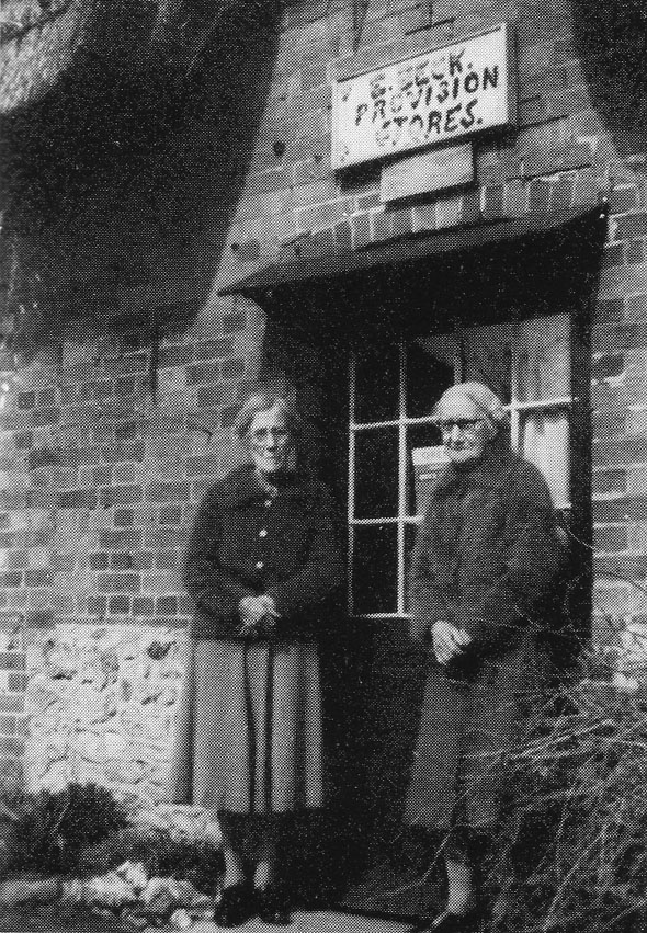
Emily and Bessie Beck of Fontmell Magna

Emily and Bessie Beck outside of their village store at Fontmell Magna (See our story The Passing of a Village Store.

Emily and Bessie Beck outside of their village store at Fontmell Magna (See our story The Passing of a Village Store.

The Passing of a Village Store

Today we lament the closing of our village shops, forgetting it is we who are ultimately responsible by choosing the supermarket. The demise of the village store is not a new phenomenon; it has been happening over many years. This is the story of a little Provisions Store in the village of Fontmell Magna and the people who ran it until it closed about sixty years ago.

It was not unusual for small village shops to be a part or corner of a cottage. What is unusual about this shop is it had no shop-window in which to display its wares, just a glass-fronted entrance door above which was a shabby little sign reading “E. BECK, PROVISON STORES.” The thatched cottage, judging by the solid grey-stone and faded bricks, some of them built into a herringbone pattern, dates from the late seventeenth to early eighteenth century.
 
We know from the 1841 census the cottage was occupied by George and Sarah Hart and their one-year-old daughter Anna. George Hart was a cordwainer (a shoemaker) who would walk 40 miles each way to Bath to collect leather for his business. The following decade was eventful for the family: George opened a bakery on the premises and during this time three sons and two more daughters were born.

In those days Fontmell Magna was a busy place familiar with toil and enterprise for it had a vibrant local economy. People were employed on the estate and in the woods, as well as in the brewery, malthouse and foundry.

Few cottages could boast any baking facilities. Cooking was usually done in a large iron pot suspended from the ceiling by a chain over an open fire on the hearth. Everything went into the pot: swedes and turnips from the fields joined garden vegetables and bacon from the family pig. Occasionally a rabbit or a hare might add to the feast and some might even have known the taste of venison. Poaching was not unknown in these parts.

The Harts were an enterprising family. The 1861 census confirms George Hart continued to repair footwear and make boots, helped by his 16-year-old daughter, Kezia, who is described in the census as a shoe binder, while his older daughter, Anna, made straw bonnets. Sons George and Samuel, respectively 18 and 14, were employed as agricultural labourers.  The youngest children – Mary, Stephen and Frederick were still at school.

The 1871 census reveals that sixty-year-old George is concentrating on his shoemaking business and is leaving the running of the bakery to his sons Samuel and Stephen, who are assisted by their sister Mary. During the next decade there are further changes at the bakery, which expanded and was selling provisions. Ten years on, George is back assisting his son Stephen with the bakery as well as working a five acre farm. George’s wife Sarah passed away in 1883 aged 71.

It was not unusual for people to bring to the bakery their cakes, tarts, pies and their meagre joints to be baked in George Hart’s oven. Over the following few years it is likely the young daughters of Tom and Jane Beck would have been sent to the store on errands for their mother and for two of them the bakery-come-village shop was to play an important part in their lives.

At the age of 80, George was still making boots and farming his five-acres. Stephen Hart is 39 years of age and, still a single man, he had sole responsibility for the bakery and provisions store. George Hart passed away in 1898 at the age of 87. About this time another bakery opened in the village.

With the advent of the 20th century, Stephen is running the bakery and shop alone; his brother Frederick, a tailor and a widower, is living with him. Stephen is an officer of the village Methodist Chapel.
 
The Beck family were also members of the Chapel. Tom Beck and his brothers John and Joe and his nephew Charlie from Iwerne Minster would lead the carol singers as they went round the village. Tom also played the cornet and was the unofficial village barber, charging a penny a trim; in the winter one of his daughters would hold a candle for him. Tom was employed as an estate woodman.

In 1901 Tom and Jane’s daughter Emily, who was born in 1877, was working away from home at Bournemouth, where she was a domestic servant in the household of an Auctioneer and Estate Agent. Her sister Bessie, who was born in 1882, is still living at home with her parents in their little cottage beside the millpond.

When Emily returned to the village she became Stephen Hart’s housekeeper and moved into his cottage and soon became involved with the running of the provision store and sometime after 1911 she became Stephen Hart’s business partner.

 When Stephen passed away in 1927 Emily decided to close the bakery side of the business and concentrate on the shop. Her younger sister Bessie had been helping to run the shop and looking after their aging parents. Tom Beck passed away early in 1928 aged 81 years. Bessie and their mother, Jane, moved in with Emily but about eighteen months later their mother passed away, aged 82 years.
 
The enterprising sisters started a guest house in addition to the shop and they continued throughout World War II and the fifties. Early in the sixties the sisters bade farewell to their last guests, served their last customers in the shop, and retired.

Village shops used to sell everything from bread, cheese and bacon to cards, buttons and bows, often all over one counter. Shopkeepers usually provided the comfort of a chair for customers while they prepared their purchases and passed on the latest news and gossip circulating in the village. In places like Fontmell Magna these scenes are distant memories.

Emily and Bessie Beck gave a lifetime of service to the village of Fontmell Magna and they were both in their eighties when they retired from their business. Emily was a Sunday school teacher at the chapel and Bessie kept it looking spotless and was part-time organist there for 50-years.

Emily was known as Miss Emmie – she died in 1969 aged 92; and Bessie died in 1977 having reached the age of 95 years.

We have placed a photograph of Emily and Bessie Beck in the photo section.

Dorset’s Lost Villages

In his landmark study of 1954 ‘The Lost Villages of England’ landscape historian Maurice Beresford cites nineteen places in Dorset where a village had existed in the middle ages, but was later abandoned.

This tally of lost parishes or hamlets does not include the contemporary example of Tyneham, which is probably best known throughout the county as a textbook case of a deserted village. But Tyneham was a community deserted under duress, and under the national emergency of a world war in which the military were above the law in commandeering land and properties for gunnery training. The desertion of by far the majority of England’s medieval villages however, was a much more insidious process, and was mainly underpinned by instances of failed harvests, plague, enclosure, ecclesiastical sequestration, economic decline, or combinations of these. And this process was taking place at least a century before Tyneham and more typically several centuries before it.

Rural depopulation of course is still going on today. Some may say that in a sense many villages still occupied are “lost” or deserted in winter because of their high proportion of second homes owned by affluent townies who have priced local people out of their local housing. The present generation has therefore been forced out in search of employment and an affordable home.

There is no question of second home ownership causing the decline of those villages lost before the 20th century, but rather the other factors already mentioned. We tend to think of villages as collections of houses, farms, a few shops or pubs clustered around a church, green or pond. But following complete dereliction the buildings will progressively fall into ruin. If the buildings were mostly of brick or stone they would understandably persist for many decades, even in the erosive British climate. But the housing stock in medieval times was usually of much more perishable materials such as timber, thatch, wattle, daub and cob, which would have vanished completely over four or five centuries, hastened probably by robbing or re-use of the materials.

What would be left once the buildings had disappeared? As over the centuries of its use the streets of a former village would be worn down relative to the surface upon which buildings stood, what then remains is a field of earthworks in very low relief showing home platforms (tofts) usually aligned along one or two streets preserved either as holloways or shallow linear depressions. Crofts or gardens, quarry pits, well-shafts or rubble footings may also be present. Often beyond the settlement earthworks one would see the ridge-and-furrow of the medieval open-field system of arable farming. Of course, we invariably see these features preserved only in fields, which have permanently reverted to pasture and have never been ploughed, since this activity would destroy the earthworks.

The later 14th and 15th centuries in Dorset are noted for villages either abandoned entirely or reduced to a hamlet or single farmstead. For instance Holworth in the parish of Chaldon Herring is one of the few sites to have been excavated. Here, a rectangular field of about 6 acres shows house platforms and a holloway, marking when a row of cottages once stood along the north side of a single street. Behind the tofts can be seen linear strips and boundaries of each property’s garden and field running down to a stream.

In Dorset several instances occurred where a village was moved to another site by a monastic house or a powerful country squire wishing to empark more of his estate. This is what happened to the first Milton Abbas, one of a long string of villages along the Milborne Brook. This village prospered from the estate of the Benedictine Abbey in the 10th century, but between 1770 and 1776 the then squire Lord Milton (Joseph Damer) relocated 100 homes, 3 inns and a school to a new site, so that he would have an un-interrupted view from his new manor house. The old Milton then disappeared beneath a new ornamental lake.

Again, Moor Crichel was moved to a new site in the parish of Witchampton and re-named New Town by Humphrey Sturt when he enlarged the estate of Crichel House, though in New Town only one cob and thatch house remains today. East Lulworth was a thriving coastal community with a castle and deer park in 1770, but by 1790 the village had been relocated half a mile to the east so that the castle estate could be enlarged. Fortunately for posterity, on this occasion the village life before removal was recorded in a painting by Margaret Weld. Kingston Russell declined in the 16th century, though nine cottages survived east of the manor house until the turn of the 18th century. The building of Kington Russell House (16th-17th centuries), arrested the decline until the 19th century, when landscaping removed what remained of the village.

It is noticeable that in their distribution the abandoned villages are most abundant on the chalk lands. For example in the Cerne Valley there are six within two miles of one another. Those so far identified have been named Pulston (A&B); Herriston (A&B); Cowden and Charlton. Even more noteworthy are a group of four in the upper Piddle valley south of Piddlehinton, all but one of these being completely deserted. There are Combe Deverel and North and South Louvard. Another group lies along the upper North Winterborne valley and includes West Philipston, which was deserted in the 15th century, and West Nicholston.

The valley of the Piddle is also notable as the location of Bardolfeston, one of the most familiar deserted villages of Dorset, which lies adjacent to Athelhampton. Bardolfeston was originally a parish in its own right but was finally abandoned in the 16th century after a long decline attributed to the building of Athelhampton House in 1495. The manor and hamlet of Cheselbourne Ford, near Dewlish House, had a population of 6 in Domesday, just 4 in 1327, and no inhabitants at all by the mid 17th century. It is only visable today as a series of closes on the west side of Devil’s Brook.

Knowlton, in the parish of Woodlands is better known for its complex of ancient henges and ruined church, but the village itself, which grew up along the south bank of the River Allen, was long ago deserted. However, nearby is the farmstead Brockington, which impinges on extensive settlement remains covering 10 acres. This area includes the site where Knowlton once stood, and seems to indicate that the two were once almost united.

In the north-east parish of Sixpenny Handley was once the village of Minchington, one of two settlements belonging to Shaftesbury Abbey in the reign of Edward II. Its size and extent remain unknown and no part of the site is occupied by a building today. Similarly, Philipston is recorded as being in the parish of Wimborne St. Giles, but does not appear on Isaac Taylor’s map.

Two other places who’s names and buildings only survive today in a single farm are Didlington and Lazerton. Didlington was a hamlet held by the church at Domesday, but by 1743 all that remained were some building foundations, the chapel’s font, and a mill on the Allen. The village had disappeared entirely by 1765, leaving only as Didlington Farm. Lazerton is much better known as an authenticated site between Stourpaine and Iwerne Stepleton. Domesday recorded a population of 30, but the hamlet had almost vanished by the mid 15th century, leaving the name to survive only in Lazerton Farm. Iwerne Stepleton was itself deserted by 1662, leaving only the house with the remains of the parsonage in its grounds. The RCHM placed Cripton as a manor and villa reduced to a small farmhouse on or very near to Came Home Farm, though no remains have been found here.

Winterborne Farrington was a separate parish in the south Winterborne valley. Hutchins wrote that by 1773 Winterborne Farringdon was entirely de-populated. Both Farringdon and Winterborne Came were experiencing decline as early as the 14th century. On the site of Winterborne Farringdon only the east gable of St. Germains Church is still standing amid the earthworks of the village it once served.

Other of Dorset’s Medieval Villages’s, which may be noted are:

Modbury is one of two truly deserted villages in the Bride valley north of Bridport, located across the road between Litton Cheney and Burton Bradstock.

Holworth was a village of Saxon origin found on excavation to have had Romano-British occupation on its site. It was part of the Milton Abbey Estate at Domesday.

West Burton and West Ringstead represent two former settlements in a coastal position. West Burton is first mentioned in a Charter of Bindon Abbey in 1313 but was entirely abandoned between the 14th and 15th centuries. West Ringstead is a 10 acre site showing clear outline traces of a village with some remains of the church on land near Ringstead Bay.

Sturthill lies adjacent to its chapel and has a traceable plan. It was disused and in ruins after the 17th century.

Colber is the only authentic deserted village site north of the chalkland belt. It lay west of the Stour opposite Sturminster Newton. Eight acres in size it was a royal manor at Domesday, but is now only a parcel of empty open ground.

Gatemerston is the only instance so far known of a hamlet being spontaneously evacuated by fire. Its exact location is no longer known, but is thought to lie on the West to East Lulworth road.

Fishing Off Chesil Beach

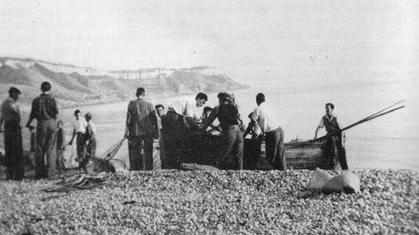
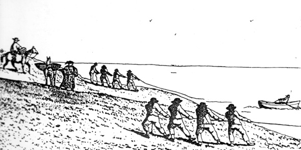
Seine netting on the Chesil Beach. Our thanks to Nigel J. Clarke Publications for allowing us to use their image.

Seine netting on the Chesil Beach. Our thanks to Nigel J. Clarke Publications for allowing us to use their image.

A Lerret Boat

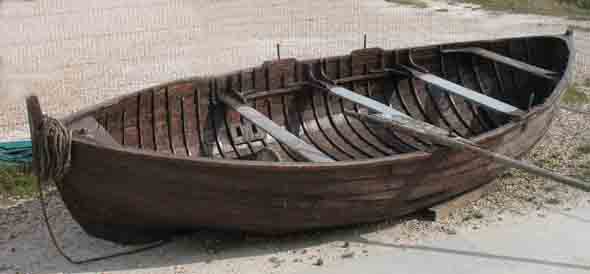
Silver Star 2 - one of only a few remaining lerret boats. Photo by David Carter.

Silver Star 2 - one of only a few remaining lerret boats. Photo by David Carter.

Chesil Beach

Fishermen on Chesil Beach

Fishermen on Chesil Beach

January 1748 – Ten Days of Mayhem on the Chesil

On the 17th of April 1747 the ship Hope set sail from Amsterdam for Curacao, then belonging to the Dutch. She would sail on to the Spanish Main to sell her cargo to the Spaniards, who, because of the war with England, were in some distress in the American provinces. In command of the ship was Captain Boon Corneliz, who had at his disposal a crew of 73 men and 30 guns, although on the outward voyage only 21 guns were mounted ready for action against pirates or the English Navy, should they seek to engage. The ship was owned by the Dutch merchant firm Hendrick Hogenberg and Co, who had loaded the ship with cloth and bale goods.

Business done and nearing the end of her voyage home the Hope of Amsterdam was off Portland on the 16th of January 1748, having sailed through storms and tempestuous seas the previous fourteen days. All 30 of the ships guns were mounted, perhaps because the cargo of gold, jewels and other valuable commodities it was bringing home was, by the most conservative estimate, worth at least £50,000. Its guns would have been sufficient to fight off any attacks from pirates but against the elements they were no help and off Portland that night Captain Corneliz and his crew needed all the help they could get.
 
No light was visible from the Portland lighthouse, perhaps because of the mist or possibly due to the neglect of duty by those responsible. It was about one or two o’clock in the morning and very dark when the Hope ran ashore on the Chesil beach. When she struck land the mast fell with the force of impact, the ship shattered into three parts. The upper deck was thrown upon a ridge of pebbles and the cabin was buried in the sands; the hull was never found and was thought to have rolled back into the sea. Amazingly, all of the men aboard got safely to the shore.

Word of what had happened quickly spread. A mob soon flocked on to the Chesil from the adjacent villages and from all parts of Dorset and the neighbouring counties. The men of Portland, Wyke and Weymouth were first on the scene and seem to have had a well rehearsed drill for dealing with these events. They formed themselves into a body with colours to secure the goods that floated along the coast. They split into groups of 20, which united as necessary under a leader. A report written latter suggests there were between three and four thousand local men employed in this endeavour and as others arrived from farther afield the numbers on the beach swelled to several thousand.

For ten days the mob held the beach. One report described “a scene of unheard of riot, violence and barbarity.” Another report described the scene thus: “a crowd swarmed about the water’s edge grubbing for gold, tearing up the shingle with their bare nails, fighting over gleaming coins like starved wolves.”

On January 18th the crew set-off for Holland, except for the Captain, his First-mate and another officer. The Captain was forced to leave the beach; the officers of Customs and the Justice of the Peace officers were overawed by the mob that carried on digging and turning-up the beach. On January 20th several bags of money were found six feet under the pebbles.

After ten days three neighbouring Justices of the Peace with a body of armed men dispersed the mob. An inquiry was held and the authorities set about tracing the possessors of the plundered goods, who were compelled to hand over to the agent of the ship’s owners gold, jewellery and other goods with a value of between 25 and 30,000 pounds. They were allowed something for salvage rights.

Some men were committed to prison and two men appeared before Judge Baron Heneage Legge at the assizes in Dorchester on July 15th 1749, to answer for their actions but they were acquitted. The jury accepted their rather far fetched claim that the Dutch were pirates who had argued amongst themselves over the division of their bounty and then deliberately ran the ship on shore and deserted her for fear of being taken and punished. The two argued that the Dutch had taken the goods from the Spaniards, who had bought and paid for them; thus they maintained it was lawful to plunder pirates. The jury also took into account that only two men were before them when all manner of disorders were committed by many of the reported several thousand men who were on the beach for those ten lawless days and nights.

At the time there were stories of men with “bulging pockets” being robbed and strangled on the beach but there is nothing to confirm this. Men did die on the beach but from the affects of the extreme cold aggravated by high winds.

There are modern day examples of similar occurrences. In 2007 the Napoli, on a voyage from Belgium to Portugal, ran aground off the Devon coast. Several containers loaded with consumer goods floated ashore. Hundreds of people flocked to the scene to see what they could get, some leaving with BMW motorcycles worth thousands. The authorities had to point out that people removing goods and not properly declaring them risked fines of up to £2,500 but this did not deter many people intent on seeing what they could get their hands on.

“Poor Silly Creatures”

Who rules England:  the King or Parliament? That was the question setting the country alight in the middle of the 17th century. Both had their armies ready to slog it out to the death and it seems either side gave scant regard for peoples land, crops or property.
 
Here in Dorset and some other counties the less politicised among the population got thoroughly fed up with Charlie and Ollie’s gangs trampling down their crops, stealing their livestock and causing mayhem in their towns and villages. So they decided to form their own gang, becoming known as the Clubmen because of the crudity of their weapons: clubs, pitchforks and scythes in the main.

The Clubmen owed allegiance to neither side and were made up of a ragbag of yeoman, farmers, and villagers with a few parsons shouting orders from the sidelines. They were intent only to preserve the peace in their communities, save their land, livestock and possessions and to put an end to the pillaging carried out by the troops of the opposing camps.  A simple white cockade was their uniform and they marched with banners proclaiming: ‘If you offer to plunder or take our cattle, be assured we will bid you battle.’
 
Battle they did. For their trouble, they usually came off worse. To Cromwell, who first came upon them at Duncliffe Hill a little to the west of Shaftesbury, they were an annoying distraction who posed no real threat to his plans or his men. In August 1645 the Clubmen gathered on Hambledon Hill – between 2,000 and 4,000 angry citizens. Led by the Revd Bravel of Compton Abbas , they were ready to do battle against whatever Cromwell threw at them.

Earlier, during the siege of Sherborne Castle,  General  Fairfax  ordered the arrest of about 50 of the Clubmen’s leaders while they were holding a meeting at Shaftesbury.  On the 4th of August 1645 Cromwell, having successfully laid siege to Sherborne Castle, had an army of about one thousand men freed-up.

These Parliamentarian soldiers were far fewer in number but better organized, armed and commanded. They attacked the Clubmen, including four members of the clergy ,from the rear most of them fled. Those left on the hill were chased by about 50 of Cromwell’s dragoons.
 
Hambledon Hill was to be the Clubmen’s last stand in Dorset.  The dragoons rounded up about 400 Clubmen off the hill and locked them up in St. Mary’s church at Iwerne Courtney, leaving them to stew overnight. The next day Oliver Cromwell himself having already decided they were “poor silly creatures” came and lectured them and then to everyone’s surprise let them go home including the “malignant priests, who were principle stirrers up of the people to these tumultuous assemblies.”

Joshua Sprigg, who was General Fairfax’s chaplain, is quoted as saying; “If this had not been crushed in the egg, it had on an instant run all over the Kingdom and might have been destructive to the Parliament”.  In some people’s minds then, the Clubmen were a force to be reckoned with after all.

Hardy’s Wessex – 170 Years On

The 2nd of June 1990 dawned as a day of great moment for the people of Dorchester. The county town was festooned with bunting, and there was a carnival atmosphere, for that week Dorchester and its county were observing and celebrating the 150th anniversary of the birth of Dorset’s greatest son in the world of words: Thomas Hardy.

It is not the intention here to present yet another potted chronological discourse on Hardy’s life and works. For that one can refer to any one of about a dozen exhaustive biographies currently in print. Instead, this is a speculative account of how the great man would find his patch of native soil today, and to contrast his Dorset with today’s Dorset. Were Hardy to come back today, would he soon need counselling for culture shock? This is perhaps more than just idle speculation, because as elsewhere so much has changed in society, economics, the environment and infrastructure since the innocent carefree days of the 1920’s when a bed-ridden Hardy took his last breath during a stormy January night.

Hardy’s birth-cottage at Bockhampton has of course been pickled in aspic for posterity, but Max Gate, the home he later built for himself near Dorchester, had a virgin beginning. When the author first moved into the rather oppressive redbrick house in the latter 19th century it stood almost in the middle of nowhere, a new dwelling place on a blank field. The fringe of Dorchester then maintained a respectable distance, but the march of time has put paid to Max Gate’s isolation. Today the house, now in the care of the National Trust, became hemmed in some 30 years ago by an estate of modern housing. Not far to the north the green belt country which once separated the author from his county town has since been torn asunder by the course of the town’s southern bypass.

Max Gate was soon besieged by admirers collecting souvenirs from the garden or hoping to catch a glimpse of the author at work. To ensure his privacy, one of the first things Hardy did at his self-styled home was to plant saplings out in the front, one of which he had tenderly reared in a pot on his windowsill while he was living at Wimborne. By the night he died they were noble in-closing trees darkening the rooms, but which waved their branches in farewell in the January gale when the old man died.

The author of ‘Under the Greenwood Tree’ would at least be pleased to see that the Max Gate trees have of course been protected and preserved, but over the years many other trees and hedgerows countywide would have succumbed to disease, neglect, vandalism or development. The manageable farm holdings of Hardy’s day have fallen prey to the post-war industrialisation of arable agriculture, with its powered machinery such as combine harvesters and suction milking machines, laying off milkmaids from milking sheds and the many who once harvested the crops with scythes and slaked their thirst with cider swigged from stoneware flagons brought onto the field. They were the agrarians who needed no pesticides, herbicides or artificial fertilisers; they would never know the meaning of BSE, CJD, Scarpie, Wine Lakes, Butter Mountains or paperwork from Brussels.

From Max Gate, Hardy could look towards his ancestral parish of Stinsford. It was here in St. Michael’s Church that his parents met and fell in love while playing together in the Church band. Thomas Hardy Sr. was a fine violinist, an instrument his famous son also took up when he too joined the family band. At that time St. Michael’s had high-backed pews and a minstrel’s gallery where the band played during the services. The gallery has long since been removed to accommodate the organ and the pews too, have been replaced by single seats. (Note: New gallery and organ installed in 1996 – see Parish Church article.)

At the time of Hardy’s death there were still some communities in the remoter parts of the county without electricity. Electrification did not come to Whitchurch Canonicorum in the Marshwood Vale, for instance, until the 1920’s. Today every village, if not every home can tap into the national grid, so releasing its share of CO2 to the global warming debate. In the days of Hardy’s youth such energy profligacy would not have been possible, and the highly efficient insulating effect of thatching would have made the typical Dorset cottage of the early 19th century a very low emission home!

Furthermore, it would have been (almost) zero-emission in waste. Those were the days when dustbins were for dust – or the cinders raked from the previous night’s fire. Vegetable peelings from the kitchen would likely have paled into insignificance the number of food containers left over from the simple purchases at the village corner shop. And if Hardy were alive today he would surely look back with nostalgia on the days when so much more food was produced and consumed locally.

But even living in his own time the author could never have imagined or even dreamed that within 60 years of his death people would be forced to travel several miles by bus or car to shop at an out-of-town multi-national hypermarket taking up the space of two football pitches. Similarly that he would witness a rash of takeaways blighting the green urban fringes to dish out fast meals of convenience, or a countryside blighted by power pylons, phone masts, vulgar advertising hoardings or distracting road signs. Besides the visual pollution the author would have been shocked by the elevated decibels of noise as well.

Another great change, this time in the landscape of the county, which would likely have appalled the writer was the commercial afforrestation of the heaths. Hardy had long been captivated by the mystic, enchanted atmosphere of his Egdon Heath at dawn and dusk. So much so that he once invited the Cheltenham-born composer Gustav Holst to visit and get a feel for the heath with the intention of capturing its essence in a composition. Back at work in Gloucestershire Holst’s score became his popular orchestral tone-poem ‘Egdon Heath.’ This heath retains something of its primordial atmosphere today; sadly though, the economic imperative of needing to replace timber stocks after the First World War became paramount, and other heath land was to disappear under conifer plantation managed by the Forestry Commission within the last decade of Hardy’s life.

Compared with Hardy’s day it might be thought that today’s Dorset is a place more selfish, uncaring and destitute of moral rectitude. Certainly during the late 19th century a remarkable evangelical revival was underway, turning people’s thoughts back to the wise council of the scriptures as a guide in their daily lives. The reward for this observance was a prosperity that grew and blossomed in a climate of public order and deference to authority. Yet  Hardy’s later friend and fellow county-man, Newman Flower, could write in ‘Just as it Happened’ that as late as the 1890’s people were being thrown into Poole Harbour at election time, gamekeepers were being shot at in woods, and horsemen were being ambushed by robbers “of Dick Turpin order” on the highways.

It would however, not entirely be correct to think that the comparison between the Dorset Hardy knew and the Dorset as we know it concerns two distinct sets of conditions with no margin for overlap. From what has gone before, a definite conclusion emerges. It is that the socio-economic changes which have culminated in the “shock of the new” making the England of the 1990’s and now the 21st century what it is had already begun in Hardy’s lifetime. This is because he could bear witness to the negative effects of the aftermath of the Great War, which began to appear incrementally in society in the decade following the armistice. And it did not stop at the decline of morals and the advance of electrification, petrol-driven vehicles and telecommunications. Hardy still lived to see the first five years of radio broadcasting and even the first lowly beginning of television transmission.

But overall technology was still at a comparatively primitive level in Victorian England, and hi-tech was virtually unknown. Bearing this in mind it may come as no surprise to some that it was only gradually that Hardy overcame an inherent predisposition to technophobia. He balked at the new technology and revolution in travel brought about by motor cars when they arrived, declaring that legs were in our gift for walking on, not to wrap up in a fur to operate pedals! Even the telephone became an object of suspicion. Years went by before he used the telephone installed at Max Gate, and only then was his resistance broken when a lifelong friend rang “Dorchester 43” one day and insisted on speaking to him personally. Once this rubicon was crossed, however, he was ever after faithful to the invention.

In conclusion it is perhaps best to say that, on balance, the changes in Dorset over the past 170 years have been an inevitable double-edged sword of the bad and the good, of both progressive and retrograde steps.