Dorset Ancestors Rotating Header Image

December, 2009:

Tyneham – The Village that Peacetime Betrayed

“Please treat the church and houses with care. We have given up our houses where many of us have lived for generations to help win the war to keep men free. We shall return one day and thank you for treating the village kindly.”

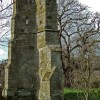
These heart-felt words, pinned to the door of a church at a time of great desperation during the dark days of World War II could hardly have been more ignominiously dishonoured through the insensitivity of officialdom. The church was that of Tyneham near Worbarrow Bay in east Dorset and the tragedy behind those words written in good faith was for them never to be respected by faceless ministers, never to be honoured when the victory was won. Seldom has the expectation of happier days been more brutally betrayed by the eventual reality, by what the passage of time would tell.

The catastrophe, which brought the Tyneham villagers’ world crashing down, and left their community to rot amidst bats and owls, struck on December 19th 1943 with an official notice from Southern Command. With the most appalling sense of timing imaginable the entire population was to be evacuated, virtually with immediate effect. A close-knit community which had peopled and shaped a village for generations was to be ousted by the military without even the decency of being permitted to spend one last Christmas in their own homes.

Inevitably the question would arise: could not the military have waited but one more week? The military chose not to. Tyneham – and a huge area of pristine Purbeck downland, were commandeered for use as a tank gunnery school. The Army, it seemed, needed all those undefiled acres as ranges for tank training – with live shells.

Notwithstanding the cold, wet December of 1943, the young, the old, the halt and sick were callously pitched from their ancestral dwellings, many to be re-located by the compassionate Town Council of Wareham. Others had relatives to go to, or took “temporary” accommodation. Pupil, postman, parson, gardener, teacher, builder, baker – all were forced out with their chattels under the premise of a noble sacrifice for the duration of an emergency. Those offered subsidised council housing in Wareham could regain some semblance of a normal life, and the town’s Tyneham Close bears witness to where the displaced were re-housed. For the young, some re-adjustment to the new circumstances was possible; though gnawing pangs of homesickness would never fore-sake them.

The old of course were not so fortunate. Jack Miller, an ageing fisherman who owned a cottage overlooking Worbarrow Bay, was offered a condemned cottage at Langton Matravers for himself and his wife, but was dead from bronchitis not long after the end of the war. Langton’s windy and foggy atmosphere gave Mrs Miller arthritis, despite the Women’s Voluntary Service labouring on the Miller’s behalf to make their home from home habitable.

Boatbuilder Will Strickland was another fellow villager who also did not long survive his displacement. People like Strickland, who made their living from the sea felt they had nothing more to live for once they became estranged from it. The once sturdy health of these old salts was broken. They ailed, and like a dog, which loses a beloved master they pined, suffering that great death of the spirit so often the precursor to the death of the body.

On VE Day (only 17 months after the evacuation) none of the evacuees in Wareham and elsewhere dared to raise their hopes too highly that the Purbeck ranges would now contract or be closed. By 1946 nothing had changed, prompting the Tyneham villagers and their supporters to begin a long campaign for the return of their valley to civilian occupation. Following the lapse of wartime censorship for security reasons the villagers could expect press publicity about their plight to begin to circulate nationwide. ‘The New Statesman’ and ‘The Star’ were notably in the vanguard in bringing the Tyneham case to national attention.

In March 1948 a two-day public enquiry was convened after news broke that the derelict homes in Tyneham were to be compulsorily purchased. Acting on behalf of the Tyneham people J. Scott Henderson KC made a watertight case for the return of the ranges to peaceful uses. The clay-pit workers and miners of the area, natural history societies, the YHA and NFU, and several other organisations and churchmen with vested interests also pressed for the War Department’s pledge of withdrawal to be honoured.

What emerged from this enquiry was that the Government did acknowledge that the withdrawal pledge had been made; yet the area was still required by the Army. The reason, as Brigadier Duncan for the War Department explained, was that by 1942 American tanks required a range of over 2,400 yards, so that there could be no contraction of the target area. It was this simple most important fact that underpinned why such an extensive area was needed; why a century’s old community found itself in the line of fire.

For the displaced villagers, who became more expectant that re-occupation could be nigh, the compulsory purchase was a devastating blow. At a hastily convened meeting in Wareham the then Minister of Town and Country Planning, Lewis Silkin, broke the bad news. The only comfort he could offer was that: “every effort would be made to make sure that when firing does not take place the public should have access to the road to Worbarrow Bay.” Those who contested the CPO were informed their properties would be requisitioned anyway.

At the time of this enquiry the Tyneham, Lulworth and Holme Ranges – together with Bovington – occupied about 11,500 acres! Tyneham House, for generations the village’s cosy manor, was boarded up by a mason. Then an uneasy peace descended upon the ranges. The exiles, as best they might, never gave up hope of one day being able to return to re-purchase their properties and repair the effects of target damage and the elements.

Then in 1960 the War Department gave the screw another turn. Territorial demands were extended still further, with the closure of more roads and rights-of-way to the public within the range area. Angry letters flew to the local MP, the Transport Minister and the War Department. In January 1961 an extension to the closure to certain roads on the East Holme and Lulworth Ranges prompted further enquiries in Dorchester.

However, hopes of liberation from the Purbeck Ranges briefly arose in 1963. Then Col. Forbes Hendry, the Aberdeen MP, suggested in the Commons that the Army exercises in the south could be re-located to Scotland, where there were better facilities and more extensive, suitable terrain for tanks than the environmentally sensitive Dorset coast. Hendry’s very valid point fell on deaf ears, mainly from the peculiar excuse that the tanks would get stuck in the mud. As it was pointed out that in Purbeck the ground was persistently muddy even in dry weather, the objection was very strange indeed. Although the Army did open Tyneham car park on Bank Holidays, it seemed always on the lookout for any excuse to exclude the public indefinitely.

The first and only human deaths to occur on the ranges probably provided the best excuse the Army could have wished for. One March morning in 1967 two 14-year-old boys from Stoborough near Wareham were killed by tank fire when they strayed onto the East Holme Range. This led to a flurry of new warning notices referring to the tragedy in particular and the need for the public to heed regulations in general. But the deaths had a very positive deterrent effect on mothers, who may otherwise have had no qualms about taking their sons down to Worbarrow Bay when the Tyneham road was open.

In 1965 Monica Hutchings, who had written the script for a documentary film featuring Tyneham in 1948, moved into the area. Soon afterwards a local resident approached her concerned about the welfare of the ponies who grazed the Tyneham valley. A farmer’s wife, Mrs Hutchings took up the plight of the ranges stock and wildlife with the local RSPCA and NFU. She took photographs of the animals, intended for use as evidence at enquiries but also evidence of damage to Tyneham and its adjacent hamlets.

Then came the ministerial announcement that Tyneham House was to be demolished. Fighting her way through the undergrowth Mrs Hutchings took a picture of the house to prove that it was in no ruinous condition. Neither was the valley-head position of the 520-year-old manor in any direct line of fire. Even Tyneham House’s hereditary owner, Brigadier Mark Bond, was not consulted about the demolition plan. Remarkably, his later response was one of philosophical resignation, saying that he could neither prevent nor condone the house being bulldozed into oblivion.

A rumour began circulating in 1967 that the Army was going to pull out of Tyneham after all, and briefly there was more freedom of access while demolition lorries were coming and going. In reality, instead of a withdrawal the “overshot area” of the valley was being promoted – to a third full-scale range. New emplacements, lookouts, firing points, fences and targets were added, and new red warning flags fluttered above the cliffs.

On May 18th 1968 in an upper room of the Moule Institute at Fordington a steering meeting took place to set up what would become the Tyneham Action Group (TAG.) The intensification of targeting in the valley had been the last straw in two decades of an ever-tightening grip by the Army on East Dorset’s beautiful priceless coast. The twenty-or-so people attending had been invited by Rodney Legg, the first editor of ‘Dorset County Magazine,’ to challenge the military to “surrender Purbeck” as he put it in an editorial for the magazine.

The formation of the group then triggered a wave of press, TV and radio coverage. On the August Bank Holiday of 1968 TAG set up an information table at Tyneham car park. It was estimated that on the day almost 6,000 membership forms were issued. Also that summer the Wareham-Kimmeridge road was closed when a new firing point was installed on Creech Hill.

Using slides, Monica Hutchings gave an illustrated talk at a special meeting held in Wareham Parish Hall in November. The audience were shown the extent of damage to Worbarrow Tout, Gad Cliff (with its fulmar nests,) a pony injured by missile-wire, and houses in Tyneham itself.

On the Easter Bank Holiday of 1969, TAG held another post at the car park, this time distributing leaflets asking members and supporters to lobby their MP’s in advance of a deputation the group would be sending to the MOD the following month. On the 22nd of May the chairman and committee members presented their case to the ministry. Members spoke in turn on various aspects and photographic evidence was produced, together with a comprehensive dossier.

While TAG had every hope of success in their mission, by the late 1960’s social change was the effect, which would have an important bearing on their objective. The rise of easier travel, tourism and leisure meant that access to the coast became more sought after than ever. But the Army’s case for continuing occupation was further undermined by advances in laser technology. A new device for the Chieftain tank was developed called Direct Fire Weapons Effect Simulator, which removed the need for the firing of live shells and the sapping of unexploded ordnance afterwards.

Was the seemingly permanent occupation down to ministerial indifference pure and simple? Did the powers that be have an ulterior motive, that in leaving the Army in occupation immunity from the populating and despoliation of the coast from commercial and holiday development would be guaranteed? Or were the post-war prospects for the release of the land the first and only casualties of the Cold War on English soil?

Whatever the reason the Tyneham villagers never returned, or could return. Ultimately, in 1975 safe access to Tyneham was restored. On the 5th September that year Col. Sir Joseph Weld cut a tape to mark an official re-opening of the Lulworth Range. This marked the effective end of the long campaign to free Tyneham, and the Army would thereafter make a point of being seen to be environmentally aware. But ironically, it would be believed in some quarters that the presence of the Army had been more beneficial for the environment than originally thought.

What befell this scene of dereliction in Purbeck, and the feelings of those never able to take up the thread of their halcyon existence again, could best be summed up by the Worbarrow Bay fisherman who, returning as a “lucky” veteran from the Great War quipped: “I fought for this bit o’land, and when I come ‘ome they try to starve me out of it!”

Footnote: Please go to Editor’s Updates in the forum area for more on this story.

St.Andrew’s Church at Winterborne Tomson

In beautiful Dorset countryside surrounded by a grassed and walled churchyard is the delightful Norman church of St. Andrew in the hamlet of Winterborne Tomsom.  It owes its present condition to repairs carried out between 1929 and 1932 at the instigation of The Society for the Protection of Ancient Buildings. The architect A.R. Powys, who is buried in the churchyard, supervised the work.

In 1933, the two adjacent parishes of Anderson and Tomson combined under the former name but as time has passed, Anderson became a redundant church and is now in private ownership.

St. Andrew’s church is a single cell Norman structure with an apsidal east-end, the only Norman apse in the county. The walls of the church, made up of many different kinds of Dorset stone and flint have seen quite a lot of rebuilding over the years. The tiled roof, re-laid in 1984, has several courses of stone slates at the bottom. The charming bell-cote was repaired during the 1929-1932 restoration and houses a single bell dated 1668.

The unusually low blocked-off small elliptical window at the west end of the south wall is the result of the walls having been raised by about two-feet in the 16th century. The three large windows in the south wall allow light to flood into the church. Arguably, the square-headed windows are16th century in the view of the Royal Commission on Historical Monuments although the Churches Preservation Trust is of the opinion the windows date from the 17th century.

On entering, the visitor’s attention is straightway drawn to the woodwork presented in the box pews, pulpit, communion rail and screen; note the carved piece cut out in the screen so the preacher need not duck to enter the pulpit. The oak has bleached and paled since it was installed during the early 18th century; the cost was met by the then Archbishop of Canterbury, William Wake, who was born in Dorset at Shapwick.

Whenever he was staying at Shapwick Wake would preach at St. Andrew’s and said he found the calm atmosphere refreshing after the great cathedrals. I wonder what this rural congregation made of finding such an important churchman amongst them and preaching too them.

On the north wall is an inscription tablet erected in 1962 to A. R. Powys and cut by the engraver Reynolds Stone who had a home and workshop at Little Cheney. In the centre aisle is a floor-slab memorial with an inscription to James Ainsworth telling us he died August 12th 1849, aged 10 years, he was the son of James and Marianna Ainsworth who lived at Tomson.

Turn around and you will see over the entrance doorway a gallery with steps leading up to it. This would have seated those who could not afford to rent a family box pew or perhaps it accommodated musicians at some time.

The lime washed plaster emphasises the outward lean of the walls towards the wonderful plastered wagon ceiling.

The 1929-1932 restoration work was paid for by the sale of a collection of Thomas Hardy’s manuscripts held by the Society for the Protection of Ancient Buildings: Hardy had been a member of the society for 47 years.

The Dorset History Centre at Dorchester has the baptism records from 1723 to 1970, Marriages from 1751 to 1968 and Burials from 1769 to 1915.

St. Andrew’s is still a consecrated church but nowadays services are held only at Advent, Whitsun and Harvest Thanksgiving. St. Andrew’s is open daily to the public thanks largely to the excellent work of The Churches Preservation Trust who look after it.

Samuel Crane – Farmer Diarist of Bloxworth

Dorset farmers with a firm footing in the 18th century were not usually the kind of people known for their erudition. After all, for anyone running a farm this was an age of illiteracy and poverty; any schooling, where it existed at all, would have been very elementary. However, there were a few notable exceptions to this rule. One such person was Samuel Crane.

Crane was born near Bere Regis in 1746, one of eight children and the elder son of John and Elizabeth Crane. Of the younger son George, little is known but it is known that Sam was able to benefit from a well-rounded education, since it was noted that his handwriting was distinctly legible and precise. Probably from his father, he gained knowledge and instruction in practical husbandry and farm management. These attainments would serve him well in the years to come.

While Samuel was still a young man a wealthy landowner called Jocelyn Pickard came into the possession of Bloxworth House in the parish of Bloxworth near Bere. The house was the focus of an extensive estate of farmland which, with the exception of the northern part, was owned by the Lytchett Matravers branch of the manorial Trenchard family. Pickard had secured his tenure of the estate by marrying George and Mary Trenchard’s daughter Henrietta in 1751. At the time the best land on the estate lay to the north, where the bedrock was chalk, while to the south was a narrow belt of clay mostly suitable for pasture with some crops. Some yeoman farmers had smallholdings here.

Needing a farm/estate manager Pickard appointed Crane to the position soon after taking up residence at Bloxworth. But Samuel wasn’t just concerned with carrying out his duties. Possibly upon the instructions of his superior he began to keep what would eventually become at least two farm diaries: the first, covering the period from June 14th 1770 to August 10th 1771; the second, from February 1st 1781 to November 30th 1783. These records have proved to be of great value as sources of information about managing of the agricultural estate of an 18th century country house.

It is thought, therefore, that Crane probably arrived at Bloxworth House before beginning the first diary. Pickard was clearly eager to increase the estates’s value by ensuring that the farm was a success. However, entries in the 1781 to 1783 diary show obvious signs of some alterations being made in the style and content, suggesting Pickard was wielding some influence upon the content of what Crane wrote.

In 1771, the year the first diary was completed, Sam Crane married Jane Perrott at Hermitage, some 12 miles north of Dorchester. A faded, barely legible entry of a baptism on October 25th 1772 in on of the parish registers suggests that by this date the couple had a son, though no further or later records relating to him have ever been found. No less obscure has been the fate of Jane herself, who early disappears from the records, leaving behind her abiding mystery unresolved to this day.

While the Crane diaries furnish a wealth of detail about the day-to-day nuts and bolts of his managerial labours at Bloxworth, they are much less informative about personal details. For example, Sam did not record where he lodged at the time, though it is believed he lived in a large farmhouse in the part of the parish known as Newport. Otherwise, in these pages it is possible for the reader to compare changes in the organisation of the farm over a ten-year period – a time covering a recession when the estate workers experienced great hardship.

Samuel recorded the wages paid to the workers, though never his own. The wages include details of labour costs, staff numbers, and occupations, and it was a measure of Crane’s skill that the wage bill was brought down by almost 5% despite an increase in the size of the farm and in the amount of time worked. By March 1771, he wrote, he had increased the dairy heard, and during the writing of the first diary, the number of sheep increased to 1,100. Wheat and barley were sold for profit and cereals were also grown to supply the manor and to sell off to the farm workers. Details of wheat deliveries to the mill are also noted. In June 1771, Crane borrowed horses from two other yeoman farmers.

Also to emerge from the diaries is the fact that children were regularly employed as part of the workforce, though girls were not made to work until they were twelve. By 1782 ten men and four boys were employed on the Bloxworth farm. In that year too, five fields of hay were mown and by the 1780’s Crane had increased the size of the turnip crop. For a time, Sam had dealings with a man in Wolverton he called “my brother” selling turnip seeds and barley. Some buck wheat was bought in August 1782, but what it was used for is not recorded.

Domestic arrangements at the manor were largely in the hands of Henrietta Pickard, so that Sam had little involvement in the running of the house. His remit was limited to securing farm produce, furze, turf, hay, corn and coal. Routinely, Crane undertook journeys on horseback to make deliveries of corn.

Then soon after 1783 everything changed for Sam Crane. He left Bloxworth, his last diary entry being for November 30th that year. On August 28th, 1788 at Cerne Abbas, he married Elizabeth Davis and settled in that parish. The couple had four sons of which two, Samuel (born 1790) and James (born 1792) survived to adulthood. The eldest and youngest sons died in infancy.

In 1787 an uncle of Sam Crane – also named Samuel – had died at Alton Pancras in the Piddle valley, leaving his nephew a legacy of land called Mill Grounds at Buckland Newton and a residue of £1,700. Uncle Sam Crane, although twice married, had no surviving children so his nephew became the principal beneficiary.

Although his uncle’s will meant that Samuel was comfortably off, it is not certain whether he had any other sources of income. There is also no record of his salary as a farm manager at Bloxworth, and whether this included accommodation and food. Since by now his diary keeping had ceased, there are no details of how Sam earned a living after his move to Cerne.

Samuel Crane died in 1815, aged 69. Whatever income Elizabeth was able to provide, the time in which she could have applied it was very brief, as she followed her husband to the grave only three months later, leaving an estate worth £35,000. Today Samuel and Elizabeth lie together in Cerne Churchyard.

The following year Sam Jr and James married, at Compton Valence, women who may have been sisters. Samuel married Jane Davis and made his marital home at Godmanston; the couple’s only child died of tuberculosis at the age of 25. James married Charlotte Davis that June.

The Parish of Glanvilles Wootton

Formerly known as Wootton Glanville, the name of this small village community in north-central Dorset preferentially became Glanvilles Wootton in conjunction with boundary changes that took place in 1985. A former parochial division of Cerne, the parish now comes under the North Dorset Local Authority, and commonly shares boundaries with the parishes of Buckland Newton, Pulham, Holwell, Holnest and Minterne.

Wootton is situated on the B3146, approximately 12 miles north of Dorchester and 7 miles south east of Sherborne in the Cerne valley area, where the rich clay pastureland of the Blackmore Vale grades south-eastwards into the chalk downland of the Dorset Heights.

The earliest visible relic of human occupation of any magnitude within the parish is Dungeon Hill, an Iron Age fort and later Roman camp lying south east of the village.A Bronze Age Celt (axe or palstave) has been unearthed on Newland Common and also a very long iron spur as well as some Spanish and monastic coins, though prehistoric burials may be present.

Before the Norman Conquest Wootton was a possession of the Abbot of Middletun,then having 16 acres of meadow and four of pasture, but at Domesday it was held by William de Braiose. The earliest Lords of the Manor were the Mauger family.

Before the time of Henry 111, Henry de Glanvyll held two virgates of land as a free tenant of the Abbot. The name of Wootton appears to derive from the“Wideton(e)” of Domeday, meaning a woody place, whilst “Glanville” is the modern form of de Glanvyll or Glanvill, the name of the manorial family who held the parish in the 14th century.

The nave and chancel of the Parish Church of St Mary the Virgin were re-ordered in 1876 by G.R.Crickmay with assistance from Thomas Hardy. During this restoration it was found that subsidence of the north wall of the nave was due to it having been built over a line of ancient coffins.

Today the parish has an area of 1,705 acres (690 hectares), but in 1865 its area was 1,665 acres (674 ha). It is sub-divided into the two tythings of Wootton and Newland; a number of hamlets or farmsteads lie within its borders as possible former manors of the mother church. These include Newlands, Osehill Green and – most famously – Round Chimneys, the farmhouse of which became the later home of the first Winston Churchill and the birthplace of his son, John, first Duke of Marlborough.

The area’s soil is noted for being very favourable for growing timber, and many of the hedges have been thickly planted with oak and elm. Near Wootton Manor house there is also a fine grove of tall mature elms. By the time of the historian John Hutchins in the 18th century the village had a dispersed settlement pattern with cottages and houses occupied mainly by farmers and labourers. Only a few cottages remained as leasehold. The main agricultural activity of the parish has traditionally been sheep and dairying on rich pastureland divided into several dairy farms. In the 19th century the villagers were sending butter produced from milk to market in London via Sherborne.

Other notable early buildings are the Elizabethan manor houses of Wootton and Round Chimneys. The latter underwent a period of dereliction, but has more recently been restored in a more truncated form. Most homes in the village today are either recent or 19th century; there is a farm with a barn and a cottage with a half-hatch door called “The Smithy”, both dating from 1874.

Wootton formerly possessed two public houses: The New Inn and The Pure Drop Inn, but both of these ceased trading and have since been converted into private residences. The Post Office also has been closed and is now a private cottage. There is however a small public hall still in use near the centre of the village.

As originally planned, the laying of the Yeovil – Dorchester branch railway line was to have passed through the village, but a local landowner forcefully persuaded the planners to lay the line five miles to the west. He did however,plant several Douglas Firs in his wood.

Glanvilles Wootton and in particular the Churchill’s manor house, Round Chimneys, is of significance as it later became the home of James Charles Dale and his son Charles William Dale, noted entomologists who recorded the history and insect life of the parish. In addition James Charles Dale was the first to describe the Lulworth Skipper butterly from a specimen captured at Durdle Door in 1832.

The village is also thehome of former Country Life magazine columnist David Edelsten, author of Dorset Diaries, and landscape architect Amanda Patton, who beat 3,500 other competitors to first prize in a National Horticultural Society garden photography competition.

Changes were made to this article on 12th April 2013 Ed.

The Parish Church at Affpuddle

One crisp sunny afternoon late in the autumn a wrong turn found us at the front gates of the Parish Church at Affpuddle, struck by the large churchyard and the regiment of yews. In the spirit of “well, we’re here now” we decided to stay awhile.

The parish is large, at 4,600 acres sparsely populated by 402 people 27% of whom are pensioners, not surprisingly; elsewhere it has been described as a sleepy village. East north east of Dorchester the county town is about seven miles away from this parish the southern boundary of which is the River Frome. Much of the area is heathland, produced by the underlying Reading Beds; it rises to a ridge where there are a number of swallow-holes. One made famous by Thomas Hardy in his novel ‘The Return of the Native,’ where he places  Mrs. Wildeve at the lonely and desolate Culpepper’s Dish; said to be named after Nicholas Culpeper (1616-1654) a figure in the field of herbal medicine. On the north the land, on chalk, slopes to the River Piddle and then rises to another ridge, this is the northern boundary.

Affrith gave land from here in 987 AD to the Abbey of Cerne and it is reasonable to conclude the parish was named after Affrith and the River Piddle. At the Dissolution in 1539 the manor and advowson (the right in English law of presenting a nominee to a vacant ecclesiastical benefice) was given to Sir Oliver Lawrence of Creech Grange, near Steeple, Purbeck. Sir Oliver was the brother-in-law of the Lord Chancellor to King Henry VIII.

The church guide tells us “in 1685 John Lawrence sold the property to William Frampton of Moreton and in 1755 Edward Lawrence sold the mansion and farm to James Frampton. In 1914 Harry Frampton sold the property to Sir Ernest Debenham.” The rich London draper bought farms and cottages in the area with the idea of developing a model estate: in 1952, the estate was sold off in small lots.

The church dedicated to St. Laurence is well set back from the road in its large churchyard from where you have a view to the west of the water meadows. Stroll on to the rear of the church and you will be surprised and delighted to find the River Piddle providing a natural northern boundary to the churchyard and the garden of peace to the east of the church. The Domesday Book talks of a mill at Affpuddle and there is a small-disused mill here, the mill race is a feature of the garden of peace; a seat of Portland and Purbeck stone in memory of local historian Joan Brocklebank is a recent addition to the garden.

The church walls are of rubble and squared Portland stone, in places with alternating bands of flint and carstone, and limestone ashlar and flint in chequered-pattern, with local Ham Hill stone dressings. The roofs are mid 19th century and mainly tiled with some stone slates.

The east window, the smaller chancel pointed window and the trefoil arch of the south door are dated 1230 AD. The nave and possibly the chancel were built about 1200AD, the south porch added in the middle of the 14th century, and the north aisle late in the 15th century. The chancel was rebuilt in 1400 when the chancel arch was enlarged and at this time the south wall of the nave was partly rebuilt and two large windows put in place. The chancel arch includes a hagioscope. On the south side of the arch is an entrance to stairs leading to the rood loft. On the south wall there is a holy water stoup, and in the south chancel wall a piscina with lancet shaped head. In 1840, according to the diary of James Frampton II, the east and south walls of the chancel were taken down and rebuilt. The west tower added towards the end of the 15th century is a good early example of the Perpendicular style.

Before we encourage you to enter the church, we must make you aware of the step down immediately behind the porch door, unprepared for this we fell in landing awkwardly on the hard surface bruising more than our dignity. So do watch your step.

Once inside you will find two Norman fonts both of Purbeck marble but it is the one with the square bowl at the west end of the North Aisle that belongs to this church; the other is in storage from the redundant church at Turners Puddle.

1883 saw the installation of new seating but the carved ends from the original pews have been retained; dated 1547 they are a feature of the church and refer to Lylynton.  Thomas Lylynton, a monk at Cerne Abbey, came to Affpuddle as vicar in 1534. The pulpit is from about the same date and is carved with figures, below which are medallions with the symbols of the four evangelists and the fifth, of a pelican.

The church guide tells us “The screen dividing chapel from nave was one of Sir Ernest Debenham’s many gifts to the church. It is partly made from the screen, which used to be at the west end, and this in turn was constructed from the chancel screen.” Another of his gifts is the altar frontal of 15th century Spanish embroidery. The reredos, the figures of St. Laurence and St. Cecilia on the east chancel wall, the Virgin and Child in the chapel, and the crucifix in the war memorial shrine in the garden of peace are all gifts to the church from Sir Ernest.

We consulted three sources for information about the bells and in one respect or another, they all disagreed except in that there are four bells dated 1598, 1655, 1685 and 1722.

The Lawrence family coat-of-arms found with the monument to Edward Lawrence on the north wall of the chancel is supposed to be the same as that on the signet ring belonging to George Washington, the first President of the United States; the Lawrence family is connected to the Washington’s through an earlier marriage. In claiming that George Washington’s mother was a Miss Lawrence, the church guide may be taking a step too far: George Washington was the son of Augustine Washington and Mary Johnson Ball.

Over the past millennium the church here at Affpuddle has been cared for and improved by Cerne Abbey, the Lawrence, Frampton and Debenham families and no doubt the parishioners, all of whom can be justly proud of the part they have played in preserving and delivering this house of worship to us in the 21st century.

Shipwreck!

On July 21st 1588 an explosion occurred on board a Spanish galleon, The ‘San Salvador,’ as she was sailing across Lyme Bay at the height of the Armada. Whether the explosion was an accident or, as has been surmised, an act of sabotage is not clear, but the smouldering hulk of the ‘San Salvador’ was abandoned and towed to Weymouth where rudimentary repairs were carried out, her crew presumably taken prisoner.

The ship had been carrying the Spanish Paymaster-General and most of his gold; a chest salvaged from the wreck was put on display in Weymouth Museum. Once reasonably seaworthy, the ship was thought to have sailed for Portsmouth with a British crew but actually foundered and sank before Old Harry Rocks near Studland. The crew then either abandoned the galleon or were drowned. There the ‘San Salvador’ lay rotting for nearly 300 years until marine archaeologists recovered some of her timbers in 1984.

The wreck of the ‘San Salvador’ is just one of the earliest recorded instances of shipwrecks around the coast of Purbeck. Most notably, St. Aldhelm’s Head, the Kimmeridge Ledges and Durlston Head have all been treacherous graveyards of many a vessel and its crew. News of a wreck once spread rapidly between villages and farms. As if to a honeypot the people were irresistibly drawn towards the spectacle of these tragedies, though principally not from any humanitarian motivation. They came to plunder and salvage whatever booty they could from a hapless wreck to enrich the lowly economy of their communities or the mundane poverty of their daily lives.

Thomas Bond, addressing a meeting of antiquarians at Corfe in March 1867 told those present “the Purbeck peasants appear to have been not less addicted to the lawless practise of wrecking (robbing?) than were the inhabitants of other sea coasts.” Almost five hundred years earlier in 1371 Edward III even called a commission to try no fewer than a hundred people for their part in robbing the ‘Welfare.’ The ‘Welfare’ was a Dartmouth sailing ship on route to London from Devon when it got into difficulties off Portland and was driven aground on the rocks before Kimmeridge. On board the vessel were 32 pieces of gold cloth, richly embroidered silks and other merchandise.

At the trial in Sherborne held much later the master of the ‘Welfare,’ Robert Knolles, testified he had been molested by the robbers, who had even been cajoled by Abbot Thomas of Cerne into storing the cargo away in a building at Kimmeridge. As owner of the Manor of Kimmeridge the Abbot had “Right of Wreck” to the shore there, but because the ‘Welfare’ had run aground and was held by her crew, pillaging of the ship was not lawful. (The Abbot was himself eventually convicted along with the other accused in 1377!)

Nearly two hundred years after the ‘San Salvador’ became a casualty of the Armada it was the turn of the East Indiaman, the ‘Halsewell,’ to suffer a similar fate. This vessel foundered before the cliff between Winspit and Seacombe in January 1786 and was then splintered almost to matchwood by heavy breakers. Some of the Haswell’s fittings however, were salvaged and found their way into Purbeck homes as second hand furnishings. For example, the cupboard from Captain Richard Pierce’s quarters was built into one of the bedroom walls of a new house near the New Inn, Swanage; a mirror now hangs in Worth Matravers Church, while a delicate hourglass was put on display in the County Museum, Dorchester. But underpinning these pickings for all is the tragedy of 168 dead and many injured, the later having to be hauled to safety up the cliff by quarrymen using ropes. The wreck represented a loss to the East India Company of £60,000.

One high profile wreck soon after the turn of the 18th century was that of the ‘Earl of Abergavenny,’ a sailing ship which struck the Shambles Bank in Weymouth Bay and sank early in February 1805. Personally affected by this tragedy was the poet William Wordsworth, who’s brother John lost his life while in command of the ship at the time. He was buried in the churchyard at Wyke Regis. Next year the 200th anniversary of the sinking will be commemorated.

The winter of 1866 was one of particular savagery along the south coast. A ferocious gale in January wrecked three schooners in Studland Bay, but that July the French barque ‘Georgiana’ was driven ashore at Chapman’s Pool. The Georgiana’s passengers and crew were saved by a line fired to the ship by coastguards. During a gale on December 8th 1872 the lifeboat ‘Mary Heape’ under the captaincy of William Stickland was called out to rescue the crew of the ‘Stralsund’ a German ship which had been blown onto the Kimmeridge Ledges.

Within a week of each other in January 1879 two ships ran aground near Old Harry Rocks very near where the ‘San Salvador’ sank in 1588. The ‘Constitution’, a triple-masted US frigate, was returning from France with a load of exhibits from the Paris Exhibition when she was driven onto the rocks by high seas. After removal of the frigate’s heavy fittings so as to lighten her, a Government tug arrived from Southampton to help five other steamers spend several hours winching the vessel clear. The ‘Contistution’ was towed into Portsmouth, though had suffered only minor damage. The following week it was the of a 500-ton Norwegian timber schooner called ‘Annie Margaretta’ to crash into the headland at almost the same spot as the ‘Constitution’, but this ship was not so fortunate. By afternoon it was clear the Margaretta was a total wreck, the easterly gale having been so fierce that lifeboats could not reach the location sooner and carry out a proper rescue.

Early in 1880 the newly completed lighthouse at Swanage became operational. On April 29th, 1882 a hurricane drove the 1,250-ton Liverpool sailing ship ‘Alexandrovna’ towards the lighthouse with her topsail in ribbons. No crew were seen and the ship eventually struck Ragged Rocks to the west of Round Down. Such was the force of the storm that it took only the ten minutes needed for the rescuers to reach the spot, for the ship to be reduced to loose driftwood. All of the 77-man crew perished many of the bodies being later found wedged among rocks or drifting in the Channel. One naked body recovered from the sea was still attached to a lifebuoy.

Probably the worst shipwreck off the Purbeck coast in the first half of the 20th century occurred at 9 p.m. on Friday January 9th 1920 when the ‘Treveal’, a 3,226 ton freighter, foundered on the Kimmeridge Ledges with the loss of the captain and 35 crewmen. At the time, the ship was making for Dundee on the return leg of its maiden voyage to Calcutta with a cargo of jute and manganese. The freighter went aground when approaching St. Aldhelm’s Head and although the crew radioed distress calls and fired flares the weather was too severe for any hope of salvation. A dockyard tug put to sea from Portland in response, only to get into difficulties itself and be beaten back by darkness and the gale. The following morning another two tugs were sent – one with the Weymouth lifeboat in tow – but by this time the storm had intensified. Yet just when it was thought the lifeboat might be overwhelmed, it was swept away to safety, eventually finding shelter in Poole Harbour.

Meanwhile the Traveal’s captain ordered the ship to be abandoned, but only 7 of the 43 crew reached the shore alive. The seven survivors were pulled from the waves by the Vicar of Worth Matravers, Revd. M. Piercy, with the assistance of Frank Lander, a local villager. But for the intervention of these two men, the seven would almost certainly have been dragged to their deaths by backwash. The men were put up at Swanage’s Anchor Hotel; the bodies of their captain and 35 crewmates were taken to Worth’s Reading Room to be laid out. To this day the sunken Traveal’s cargo has not been salvaged from its grave at eight fathoms down.

For some Purbeck people walking near the coast in the earlier 20th century, one of the most memorable occasions was witnessing a ship on fire in the Channel. In January 1933 observers on the cliffs near St.Aldhelm’s Head watched in amazement as the French liner ‘L’Atlantique’ blazed from bow to stern out in the Channel at about 50 degrees 34 minutes north and 2 degrees 3 minutes west. The £3 million L’Atlantique’s Commander, Captain Schoofs, later recovered the gutted liner, its upper decks by then fallen in. He hoisted the French tricolour and towed the hulk back to Cherbourg.

But until the last quarter of the century no part of the Channel coast had ever been threatened by the spilt cargo of any ship actually wrecked many miles away. That is until April 1967 when the oil tanker ‘Torrey Canyon’ foundered and broke up on the Cornish rocks, releasing most of her oil into the sea. The resulting slick then drifted up the Channel with the then prevailing west wind, fouling many beaches in Cornwall and Devon as it went. Purbeck then braced itself for the impact of a share of the Canyon’s spillage. Miraculously, it never came; a sudden eleventh-hour change of wind direction to northerly took the slick away from Dorset and towards the French coast instead. But not befoe a £15,000 boom was thrown across the mouth of Poole Harbour as a contingency measure, though dismantled with relief that the threat had passed. Still, the Torrey Canyon’s slick killed many thousands of seabirds and had a long term effect on the ecology of the south coast.

Twelve years later in 1979 a 6,540 ton freighter called ‘Aeolean Sky’ was sailing up the Channel carrying drums of insecticide and other toxic chemicals when it was in collision with the German coaster ‘Anna Knuppel off Purbeck on November 3rd. Taking in water the crippled freight was towed towards Portland harbour but sank in 100 feet of water about five-and-a-half miles off St. Aldhelm’s Head early the following morning.

Elizabeth Martha Clarke – Her Confession

It was the 9th of August 1856: the weather was sombre enveloping Dorchester in drizzle, perhaps anticipating, but unable to stop “several thousand” people of the town and thereabouts from congregating to witness the awful event to take place there that morning.

Christened Elizabeth Martha Clark the daughter of John and Elizabeth Clark at a simple ceremony in St.James’ church Allington on the 22nd of July 1802 at the end of which the rector John Blessed entered her name in the church registers to confirm her entry in to the Church. Who could possibly have foreseen the ordeal that her life was to be and the horrors she was to face at the end of it?

Her father John Clark was an agricultural labourer surviving on a meagre income. Elizabeth, would have quickly learnt to help her parents with the family chores. Childhood would have been short.

Martha’s confession made in Dorchester Prison 7 August 1856 before The Governor and the Prison Chaplain the Rev, Dacre Clemetson.

 “My husband, John Anthony Brown, came home on Sunday morning, the 6th of July at two o’clock, in liquor, and was sick. He had no hat on. I asked him what he had done with his hat. He abused me, and said “What is that to you? Damn you!” He then asked for some cold tea. I said I had none, but would make him some warm. His answer was “Drink it yourself and be damned.” I then said, “What makes you so cross? Have you been to Mary Davis’s?”

He then kicked out the bottom of the chair on which I had been sitting, and we continued quarrelling until 3 o’clock, when he struck me a severe blow on the side of the head, which confused me so much I was obliged to sit down.

He then said (supper being on the table at the time) “Eat it yourself and be damned,” and reached down from the mantelpiece a heavy hand whip, with a plaited head and struck me across the shoulders with it 3 times, and every time I screamed out I said “if you strike me again, I will cry murder” He replied “if you do I will knock your brains through the window,” and said hoped he should find me dead in the morning, and then kicked me on the left side, which caused me much pain.

He immediately stooped down to unbuckle his boots, and being much enraged, and in an ungovernable passion at being so abused and struck, I seized a hatchet that was lying close to where I sat, and which I had been making use of to break coal for keeping up the fire to keep his supper warm, and struck him several violent blows on the head – I could not say how many – and he fell at the first blow on his side, with his face to the fireplace and he never spoke or moved afterwards.

As soon as I had done it I would have given the world not to have done it. I had never struck him before after all his ill treatment, but when he hit me so hard at this time I was almost out of my senses, and hardly knew what I was doing!”

Martha’s journey from this world to the next took four to five minutes and this can be put down to the cruelty of her executioner: William Calcraft, the hangman who favoured the short drop technique and presided over her departure from this world. Calcraft’s successor later commented “Calcraft killed, I execute….” Today society would see Martha as a victim not a killer. We must hope a more sympathetic justice awaited her.

Elizabeth Martha Clarke: “a most kind and inoffensive woman..”

Saturday the 9th of August 1856 saw Dorchester enveloped in penetrating drizzle. This miserable weather did nothing to dissuade the people of the town from being on the streets early, joining many from towns and villages the length and breadth of the county who where already assembling to witness the awful event to take place early that morning. The local newspaper estimated four thousand were out in the town.

Elizabeth Martha Clarke was in Dorchester. She had snatched only two hours sleep that night and declined breakfast deciding instead to make do with a cup of tea, for in a little over an hour she too had to keep an appointment she could not break. Those with her had noticed a quiet determination to see the business through with dignity. However, it is likely her mind was elsewhere probably recalling other times and wondering at the events that had brought her to Dorchester.

She had spent her childhood and most of her early adult years in an area known as Marshwood Vale, a quiet rural part of West Dorset where her father worked as a farm labourer and occasional dairyman and where even today it is narrow winding lanes that pass for roads. Her mother and father John and Martha Clark were married at Burstock on the 18th of February 1800; her mother’s maiden name was Hussey. She was one of eleven children and soon became known simply as Martha.

The 1830’s were the best years of her life. Probably through her father’s work she met Barnard Bearns a widower and a farmer of twice her years; they married on the 27th of December 1831. He came from the village of Askerswell and farmed land in the Powerstock area where he rented a prominent house ‘Meadways’ by the Maggerton River. Now no longer a farm labourer’s daughter, she was a farmer’s wife and content with her lot.

Barnard was for a while an Overseer to the Poor and well respected in the community.  They were happy with each other despite the difference in their ages. Their two sons both died in 1835, William was born in 1832 and Thomas in 1834. On the 4th of May 1840 the couple witnessed the marriage of Martha’s sister Ann to John Record at Whitechurch Canonicorum.

These were difficult times for anyone earning their living from the land. Records show that late in the decade Barnard had financial difficulties. He ceased to be an Overseer to the poor and had to surrender his holdings at Powerstock.

Her husband died leaving her the sum of £50. She found work as the housekeeper to two farming brothers John and Robert Symes who held Blackmanston Farm in the Purbeck hills, quite a distance from the Marshwood Vale. It is likely she knew them previously. Both brothers were born near Powerstock; John in1805 and Robert in 1811 and the brothers habitually returned to the Marshwood Vale to hire their labour. Martha was housekeeper to the Symes brothers for 14 years and John Symes described her as “a most kind and inoffensive woman.”

Also from the Marshwood Vale area was Robert Brown who was dairyman on the Symes’ farm and his son John was employed there as a shepherd. A relationship grew between Martha and John Brown. Despite the fact that she was twice his age the couple married at Wareham on the 24th of January 1852. Soon after their marriage they returned to the Marshwood Vale and the remote hamlet of Birdsmoorgate.

They lived in a house with a small shop from which Martha sold sweets and groceries. Her young husband acquired a horse and cart and set up in business as a Carter. John’s cousin lived in the hamlet along with just a dozen or so other souls including Mary Davis a young woman well known to Martha, who had the other shop in the village. But it wasn’t trade that connected the two women as rather a matter of the heart.

Perhaps it was inevitable in a such a small community that an attraction would blossom between John a young man married to a women twice his age, and Mary a young woman married to a man almost old enough to be her grandfather.

There is no doubt Martha was jealous of the attraction Mary held for her husband. John would come home late, often drunk, offering vague excuses about where he had been. Martha knew full well that he had been with Mary; she had spied on them often enough to be in no doubt.

John arrived home at 2 o’clock in the morning of  Sunday July 6th – he was drunk and vomiting. The couple argued about his supper and where he had been to such a late hour. As was often the case John was being physically and verbally abusive towards his wife when something within her snapped. She retaliated landing several blows to his head.  A moment later and John Brown lay lifeless on the floor. 

Thirty-four days had passed since Martha killed John Brown. In that short space of time there had been an inquest, Martha had been arrested, charged, tried and sentenced. The infamous Jeffreys who held court some two hundred years earlier was not alone in dispensing quick and rough justice at Dorchester.

Early on the morning of the 9th of August 1856 Mary Davis set off from Birdsmoorgate to see Martha Brown but the people of the village of Broadwindsor recognised her and insisted she turned back. There was little sympathy for Mary Davis because people knew that Brown would have been alive that day had she not encouraged his attentions.

Back in Dorchester that same morning Martha had decided to wear a black figure-hugging gown, which showed off her shapely figure. Mr Clementson and the Rev. Henry Moule were with her and gently reminded her it was time to leave: she decided, despite the drizzle, to walk rather than ride in the van.

She climbed the first flight of steps and at the top was met by William Calcraft – the public executioner. He bound her hands and she ascended the second flight of steps from where she could see the sea of faces surrounding the scaffold. She turned to Mr. Moule and thanked him for his kindness. Mr Clemetson had been overcome with emotion and sadness that his efforts to secure a reprieve had come to nought. He was unable to come to the top of the scaffold with her.

Calcraft placed her on the drop, put a cap over her head and adjusted the rope. The bolt was withdrawn and Elizabeth Martha Clarke left this world for a better place where we must all hope she was met with forgiveness and a more sympathetic justice.
 
Her lifeless body hung for the hour dictated by law, viewed by the thousands who had attended this awful event, most of them drawn there by a morbid curiosity. Amongst the crowd was a young man destined for literary greatness: the sight he witnessed that morning stayed with him for the rest of his life. Later the memory of that day was used to dramatic effect in one of his most powerful and popular novels, which is probably why the memory of this most kind and inoffensive woman lives on.

Bridport to the First Charter and Beyond

In 2003 the West Dorset town of Bridport celebrated the 750th anniversary of the granting of its first charter. This account is a short history of the major developments in the town up to that time and thereafter.

Little is known of the settlement of the area where Bridport grew up, prior to the 9th century. The nearest Iron Age fort is Old Warren at Little Bredy. The name also appeared in a document when land at Little Bredy was granted to Cerne Abbey in 987, but few artefacts of the period from about 4000 BC to 43 AD have been found. The Romans appear to have introduced the tradition of cultivating hemp and flax in the rich alluvial soils of the Brit and Asker River valleys, but did not establish any camp or town on the gentle intervening spur between the valleys.

With the incoming Saxon settlers however, the town’s history can be said to begin. Bridport began as an artificial creation in 878 AD first known as Brydian, just one link in a system of fortified burhs built by King Alfred as a defence against the Danes. The land chosen was part of the royal manor of Bradpole, and therefore a crown possession from the start. Brydian was allotted 760 hides of land, and became a centre of local administration and commerce. The burh was surrounded by a rampart of earth, turf and timber, and was probably surmounted by a timber palisade. Within this enclosure the settlement was laid out on a gridiron pattern with a wide main street. This survives in the present town as the southern end of South Street. Within the burh there would have been ample accommodation for tradesmen, and there would have been several churches.

During the reign of King Athelstan (925 to 939 AD) a mint was established in the burh, though the Brydian mint was relatively unimportant. Coin-production here continued until after the Norman Conquest, though this appears to have ceased soon after. As the town was crown property, it is likely that William I ordered the building of a castle at Bridport, and it has been suggested that a slight elevation in the ground to the east of South Street is probably the denuded remnant of the castle motte.

During the Norman period land in the Bridport area not owned by the Crown was mainly vested in the Church in the form of abbeys. A Church belonging to St.Wandrille’s Abbey existed in Bridport in 1086, and is believed to have been the antecedent of the present St.Mary’s. Many other religious houses were already in existence by the mid 13th century.

The main period of urban development appears to have occurred in the early 13th century. The influx of population from the rural manors into the town necessitated an extension of the town boundaries by 1250. By this time a new town had been laid out to the north of the earlier Saxon burh, with two main streets meeting at a T-junction. These streets replaced South Street as the main streets of the town. Trade was then drawn away from the Saxon settlement and towards the new market area with its wide streets and regular burgages. It was the growth in the town’s economy and status, due largely to the stimulation of industry to meet the demand for rope to supply King John’s military ventures, that led to Bridport qualifying for the receipt of its first Royal Charter from Henry III on June 22nd 1253.

This Charter, which had been obtained principally by the Dean of Wells, Giles de Bridport, effectively founded the borough. In the Town Hall can be seen a roll of the Bailiffs from 1290 together with the original precept from the Sheriff of Dorset to the Bailiff calling for the election of two MP’s. Edward I granted the right to return two members, and twelve burgesses were empowered, from which two Bailiff members were elected. It is recorded that Thomas Newburgh and Robert Hill were the first members representing Bridport at Westminster. From early on, a proportion of Bridport’s population comprised immigrants from Normandy.

St. Andrews was the church of the planned town to the north of, but continuous with the Saxon burh and it is noted that this church was in use as a priory by Carmelite friars around 1265. It formerly stood on the site of the present Market House-cum-Town Hall. Buildings originally occupied the space behind the Town Hall, but these were later demolished. St.Mary’s Church in South Street however is almost certainly older than St.Andrews, though much of the present building dates from the 13th century.

However, early in the 14th century there is evidence of an economic downturn, largely attributed to the wet summers of 1315 and 1316 which severely affected crops and food. Bridport was one of the first coastal towns to suffer the effect of the bubonic plague epidemic, during which peasant and labourer mortality was very high. Despite difficulties, Bridport by the end of the 14th century was the fourth largest borough in Dorset.

It is informative to see how the wills of the victims give an insight into the lives of the town’s citizens at the time. Buildings were in multiple occupation and use. Some of the wills mention land suitable for growing hemp. Land seems to have been in small parcels of 1 rood (about 9.75 acres,) and usually left to surviving family members. The forerunner of the Greyhound Hotel, formerly a tavern, came into the possession of the town authorities by means of a reversion included on a will of 1386.

The market function of the town was originally catered for by The Shambles or Butchers Row, which formerly occupied the road intersection area. Documents record that in 1556 Thomas Balston Bocher was granted two shambles in the market of Bridport for his butchery business. However, the ground floor space of the Town Hall to this day is used as a market. Elizabeth I granted Bridport the right to hold three annual fairs and a Saturday market. The broad span of the main streets today reflects the allocation of space for the market, the fairs, bull baiting, the stocks, pillory and even hangings.

Not least among the trades and industries, which had attracted Bridport’s royal patronage, were the net, rope and sail makers. These industries were fully established by 1250, and were based upon hemp and flax grown locally. The ropewalks needed to bind the rope strands together have left their mark in the long alleyways still to be seen off the main streets. Such was the industry’s importance that in 1322 six Bridport ropers were sent to Newcastle to train workers for the fledgling rope industry there. But by the 15th century rope and sail making were already experiencing the threat of competition from low-cost producers in Genoa, Normandy and elsewhere in England.

At first the workers petitioned Henry VII, warning the King that competition from abroad could devastate the economy of Bridport. When a ropewalk was set up in Burton Bradstock, the ropers of Bridport petitioned Henry VIII to pass in 1530 what might be called “the 5-Mile Act.” This act banned the sale of hemp within 5-mile radius of the town other than at its market and for the maker’s own use. This appears to have worked in the short term, for Bridport was able to maintain its lead.

Although critical to the town’s economy and status, the development of the harbour and port is a matter of considerable ambiguity among historians. The earliest reference to a harbour at Bridport appears in Hundred Rolls of 1280. It is noted that ships were coming up the river as far as the borough by1280, indicating that some quay or harbour must have been in existence from 1256. Then in 1388 Richard II made a grant to Richard Huderesfield for the purpose of re-making the harbour, which by this time had evidently fallen into disrepair. Little had been done, though, towards this end by 1392 when the King issued a second grant, this time to the Bailiff of the Vill of Bridport.

The quay facilities did however receive some help in the 1440’s, when ecclesiastical authorities raised funds for its reconstruction and maintenance. In 1619 James I granted Bridport a Charter “confirming the rights and privileges of the borough” and granted letters to the bailiffs allowing them to raise revenue towards the upkeep of the harbour. Then in 1670 Charles II granted powers to repair the old harbour or construct a new one in return for a levy payable to the exchequer. But the serious effort to build a proper harbour was persistently dogged by silting up of the outlet due to drifting Chesil sand, and would not be realised until the early years of the 18th century, even though sea-borne trade continued throughout this time.

Then in 1588 came the Armada. Two sea battles on the 23rd of July could be heard and seen by the people of Bridport. Bridport men in the Dorset Militia followed the battles eastwards overland until the fight died away in the afternoon. For a time afterwards the town experienced economic difficulties due to the familiar problem of harbour blockage. Also about this time Beaminster and Lyme Regis contributed funds for the building of a market and a school, the latter of which is thought to have stood near the present market house.

Bridport was much involved in the emigration to the New World in the early 17th century, and it has been estimated that about 200 local people sailed to Massachusetts between 1620 and1650. At least some of these would have come from the town or its west Dorset hinterland, including Symondsbury and Askerswell. The town was also assisting the policing of the coast, in operations against pirates operating out of Lulworth Cove and Studland Bay. For example in 1613 the Bailiffs of Bridport paid the princely sum of 11s.3d for expenses incurred in the imprisonment of captive pirates. This fact suggests that some kind of harbour was in operation, despite a reference in Queen Elizabeth’s Charter to a blockage by sea and wind sometime after 1619.

During the Civil War, it appears that Bridport did not suffer the degree of damage or casualty as did Weymouth, Lyme, or Corfe, probably because it was not a defended or walled borough. After the Restoration in 1660 the town’s authorities, woefully short of revenue, resolved that repairs to the Church and the roads would have to come out of parish rates. On the 11th of June 1685, the Duke of Monmouth and his rebel army landed at Lyme and immediately moved to attack the militia at Bridport, though this was based at the east end of the town at the time.

Then, 1721 an act of Parliament legislated for a harbour and piers to be built, these being completed twenty years later. To the west of the harbour a shipyard was established which would be a success from the beginning. It is not known exactly when Nicholas Bools (or Bowles) founded the shipyard, but a 52-ton sloop called ‘North Star’ was, in 1789, the first to leave one of the six slipways at the harbour. Between 1772 and 1879, when the yard closed, altogether 353 timber ships were built and launched, often at the rate of four or five a year for several consecutive years. Many of these vessels were involved in the growing overseas trade, exporting cargoes of rope, sail, nets, butter and cheese, while importing mainly coal timber, hemp and flax.

As in many other English towns there grew up a thriving coterie of clock and watch maker-repairers in Bridport from around 1700. Daniel Freake, John Bishop, J Dashwood, W Brown and Adam Cleak were the craftsmen in the forefront of the local horology business. Cleak, for instance, came from a family of Exeter clockmakers and set up shop in West Street. It is interesting that through his sister’s marriage Adam Cleak had a nephew, John Summerhayes Jr, who emigrated to New York and himself established a clock-making business there in about 1820. It should therefore be pointed out that anyone with this or a similar name living in New York State today may be able to claim Dorset ancestry through this single migrant to the New World.

In 1906, discussions on the planning for secondary schools in Bridport took place. The town experienced a drought from July to October in 1911, during which time a Regatta was held at West Bay. Then in the spring of 1913 a Town Council proposition to provide a Municipal Market for livestock caused much opposition. Bridport had at this time about eleven hundred burgesses, who were to be replaced by the Representation of the People Act of 1918.

In its own way Bridport, like every town and village in the land, had to endure the devastating years of the two World Wars. The invasion of Belgium in August 1914 led that November to the arrival of about 40 warmly welcomed refugees in Bridport. During this conflict the town’s industry went into hyper-drive to produce huge volumes of supplies. Between the wars however, there were as elsewhere, definite signs of a recession. A report headed ‘Ropes, Nets and Halters’ made it clear that this industry was showing every sign of decline and contraction.

Bridport marked the 700th anniversary of the first charter in 1953. By this time the harbour was declared to be no longer a profitable operation. Until the early ‘60’s the population of the town was in decline in response to economic circumstances. By 1963 it had declined to 6,530. The old custom of beating the boundaries was re-instated in September 1968.

Peter Beckford – Squire of Steepleton

Regular users of the A350 between Blandford and Shaftesbury are routinely confounded and irritated by a series of hazardous left and right hand bends just north of Stourpaine and someway south of Iwerne Minster. Such bends often arise when the course of a road has been determined by the furlongs and headlands of medieval open-field systems. But the Stourpaine – Iwerne bends are considerably more recent being part of a landscaping re-organisation around an estate owned by one of Dorset’s more flamboyant Hanoverian country squires – Peter Beckford.

Beckford was born in 1740 into an aristocratic family who had made their fortune from the ownership of sugar plantations in Jamaica. His father was Julines Beckford and his mother Elizabeth Ashley, was the daughter of the MP for Bridport. Julines elder brother, known as ‘Alderman’ Beckford was a highly influential figure in Parliament and in the City, reputed to be at the time the wealthiest commoner in England.

Peter spent his later childhood at Steepleton, a house and estate now lying in the loop formed by the road-bends near Stourpaine. Julines Beckford had bought the mansion in 1745 when he became attracted to the brick stables and kennels already on the estate. Steepleton was then still a modest residence but later Julines bought the adjoining estates of Durweston and Shillingstone. This suited Peter’s father, as he was a keen huntsman, but he also indulged a passion for sports, languages, art and music, interests his son inherited. He further added another wing to each end of the house in about 1758.

As a young man Peter Beckford went on a grand tour of Europe and spent a number of years in Italy when he was portrayed with one of his dogs by the painter Batoni and met Muzio Clementi, a musical prodigy who Beckford brought back to live with him at Steepleton. Clementi remained in Dorset for the next seven years before moving to live and work in London.

Beckford was also interested in political economy and Government, being elected MP for Morpeth in 1767 but as he was not of the temperament to apply himself to political duties he later stood down from the seat. In 1773 he married Louisa, the nineteen-year-old daughter of George Pitt of Strathfield Saye (later the 1st Baron Rivers,) but the union was beset with some unhappiness. For a while the couple lived in London, but Beckford’s dislike of the high society of the capital compelled him to return to Stepleton. At heart it was in the role of country squire that he was most content. The Beckford’s first three children died in infancy, but eventually the couple had two surviving children: a son William Horace and a daughter, Harriet.

The incidence of the road re-organisation came about when the landowners of the estates adjoining Steepleton wanted to build a straight and wider road but on a course that would take it across part of the Stepleton estate. They therefore sent their surveyors to Beckford to explain the plan and hoped that he would approve the work, but the Squire of Stepleton was secretly adamant that he would not do so. In a display of insincere hospitality he caused the surveyors to forget the purpose of their visit by entertaining and mildly intoxicating them with glass after glass of spirits. Eventually the surveyors were left with no option but to re-route or improve the road around Steepleton’s tortuous boundary.

Like most of his family Beckford never visited the plantations he inherited in Jamaica, and so had no idea how the life of the slave-labourers contrasted with the cosy, privileged existence of an English country squire. His cousin William had taken the artist George Robertson out to Jamaica in 1774 where he painted a number of landscapes intended to portray the lush vegetation of the island, but which did not give any hint of the poverty and hardships of the slave underclass who worked themselves into early graves to create wealth for their master in England.

However, Beckford’s time abroad as an absentee landlord of extravagant spending beyond his means had led to his estates in England and Jamaica becoming run down and unprofitable. The income from the Jamaica plantations had been falling since the 1770’s as the land became exhausted and the price of slaves and stores increased. For example a Negro slave who cost £25 in 1755 cost £60 by 1770, and the government had increased the import duty on sugar. A series of five devastating hurricanes between 1780 and 1786 compounded the slump. The value of the estates plummeted, and absentee proprietors like Beckford were at the mercy of unscrupulous managers.

To ameliorate growing insolvency Beckford sold the Durweston part of his estates to Henry Portman of Bryanston in 1774, and was forced to mortgage two of the plantations to Baron Rivers for £4,000 in 1778. Hope for the Beckford fortune lay in William Horace’s being able to inherit the Pitt estates one day when Louisa’s brother George – a bachelor unlikely to marry died. But Horace had inherited much of Louisa’s immature and unstable mentality. Beckford’s heir became a profligate gambler who ran up great debts unknown to his father, and eventually had to appeal to his uncle George for £12,000 secured on Peter’s Dorset properties in order to bail him out.

Meantime, out of boredom Louisa was diverted into an affair with William Beckford, the future builder of Fonthill Abbey, though Peter chose to ignore the adulterous relationship. After becoming totally estranged from her husband Louisa went to live in Bath. His wife away, Peter spent his time hunting and building up a pack of hounds (of which he knew each by name.) He commissioned the painter Francis Sartorious, who specialised in animal studies, to portray himself on horseback, with his dogs around him. Beckford also, between 1779 and 1781, wrote a book in the form of a series of letters to a friend called ‘Thoughts on Hunting,’ a treatise that became a best seller.

In 1783 Beckford learnt that Louisa had contracted tuberculosis, and in the hope that a warmer climate might restore her health, he took her to Italy. Louisa however, succumbed and died of the disease in Florence in 1791. She was buried in the English cemetery at Leghorn. But Beckford remained abroad in Italy until forced to return to Stepleton for good when the French under Napoleon invaded northern Italy in 1799, although he returned to Stepleton for short visits a number of times in the proceeding years. His son Horace by then 22, and daughter Harriet returned with him.

Peter Beckford died a sad old man, burdened with worry and debts, at the age of 69 in 1809 and was buried in the church at Steepleton. Though he was a man of many talents, they did not bring him happiness. He lies beneath a tomb with a square entablature bearing the Latin inscription ‘PB Sibi et Suis MDCCCIX’ (Peter Beckford; To Him and To His; 1809.)

William Horace inherited the Pitt estates in 1828, and in accordance with his father’s will assumed the name Pitt-Rivers, becoming the 3rd Baron Rivers. The inheritance however, proved to be debt-ridden, and he drowned himself in the Serpentine, Hyde Park, in 1831. Stepleton remained part of the Pitt estate until 1919, when it was bought by Sir Ranulf Baker of Ranston; he later sold off the house and park.