In his landmark study of 1954 ‘The Lost Villages of England’ landscape historian Maurice Beresford cites nineteen places in Dorset where a village had existed in the middle ages, but was later abandoned.
This tally of lost parishes or hamlets does not include the contemporary example of Tyneham, which is probably best known throughout the county as a textbook case of a deserted village. But Tyneham was a community deserted under duress, and under the national emergency of a world war in which the military were above the law in commandeering land and properties for gunnery training. The desertion of by far the majority of England’s medieval villages however, was a much more insidious process, and was mainly underpinned by instances of failed harvests, plague, enclosure, ecclesiastical sequestration, economic decline, or combinations of these. And this process was taking place at least a century before Tyneham and more typically several centuries before it.
Rural depopulation of course is still going on today. Some may say that in a sense many villages still occupied are “lost” or deserted in winter because of their high proportion of second homes owned by affluent townies who have priced local people out of their local housing. The present generation has therefore been forced out in search of employment and an affordable home.
There is no question of second home ownership causing the decline of those villages lost before the 20th century, but rather the other factors already mentioned. We tend to think of villages as collections of houses, farms, a few shops or pubs clustered around a church, green or pond. But following complete dereliction the buildings will progressively fall into ruin. If the buildings were mostly of brick or stone they would understandably persist for many decades, even in the erosive British climate. But the housing stock in medieval times was usually of much more perishable materials such as timber, thatch, wattle, daub and cob, which would have vanished completely over four or five centuries, hastened probably by robbing or re-use of the materials.
What would be left once the buildings had disappeared? As over the centuries of its use the streets of a former village would be worn down relative to the surface upon which buildings stood, what then remains is a field of earthworks in very low relief showing home platforms (tofts) usually aligned along one or two streets preserved either as holloways or shallow linear depressions. Crofts or gardens, quarry pits, well-shafts or rubble footings may also be present. Often beyond the settlement earthworks one would see the ridge-and-furrow of the medieval open-field system of arable farming. Of course, we invariably see these features preserved only in fields, which have permanently reverted to pasture and have never been ploughed, since this activity would destroy the earthworks.
The later 14th and 15th centuries in Dorset are noted for villages either abandoned entirely or reduced to a hamlet or single farmstead. For instance Holworth in the parish of Chaldon Herring is one of the few sites to have been excavated. Here, a rectangular field of about 6 acres shows house platforms and a holloway, marking when a row of cottages once stood along the north side of a single street. Behind the tofts can be seen linear strips and boundaries of each property’s garden and field running down to a stream.
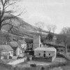
In Dorset several instances occurred where a village was moved to another site by a monastic house or a powerful country squire wishing to empark more of his estate. This is what happened to the first Milton Abbas, one of a long string of villages along the Milborne Brook. This village prospered from the estate of the Benedictine Abbey in the 10th century, but between 1770 and 1776 the then squire Lord Milton (Joseph Damer) relocated 100 homes, 3 inns and a school to a new site, so that he would have an un-interrupted view from his new manor house. The old Milton then disappeared beneath a new ornamental lake.
Again, Moor Crichel was moved to a new site in the parish of Witchampton and re-named New Town by Humphrey Sturt when he enlarged the estate of Crichel House, though in New Town only one cob and thatch house remains today. East Lulworth was a thriving coastal community with a castle and deer park in 1770, but by 1790 the village had been relocated half a mile to the east so that the castle estate could be enlarged. Fortunately for posterity, on this occasion the village life before removal was recorded in a painting by Margaret Weld. Kingston Russell declined in the 16th century, though nine cottages survived east of the manor house until the turn of the 18th century. The building of Kington Russell House (16th-17th centuries), arrested the decline until the 19th century, when landscaping removed what remained of the village.
It is noticeable that in their distribution the abandoned villages are most abundant on the chalk lands. For example in the Cerne Valley there are six within two miles of one another. Those so far identified have been named Pulston (A&B); Herriston (A&B); Cowden and Charlton. Even more noteworthy are a group of four in the upper Piddle valley south of Piddlehinton, all but one of these being completely deserted. There are Combe Deverel and North and South Louvard. Another group lies along the upper North Winterborne valley and includes West Philipston, which was deserted in the 15th century, and West Nicholston.
The valley of the Piddle is also notable as the location of Bardolfeston, one of the most familiar deserted villages of Dorset, which lies adjacent to Athelhampton. Bardolfeston was originally a parish in its own right but was finally abandoned in the 16th century after a long decline attributed to the building of Athelhampton House in 1495. The manor and hamlet of Cheselbourne Ford, near Dewlish House, had a population of 6 in Domesday, just 4 in 1327, and no inhabitants at all by the mid 17th century. It is only visable today as a series of closes on the west side of Devil’s Brook.
Knowlton, in the parish of Woodlands is better known for its complex of ancient henges and ruined church, but the village itself, which grew up along the south bank of the River Allen, was long ago deserted. However, nearby is the farmstead Brockington, which impinges on extensive settlement remains covering 10 acres. This area includes the site where Knowlton once stood, and seems to indicate that the two were once almost united.
In the north-east parish of Sixpenny Handley was once the village of Minchington, one of two settlements belonging to Shaftesbury Abbey in the reign of Edward II. Its size and extent remain unknown and no part of the site is occupied by a building today. Similarly, Philipston is recorded as being in the parish of Wimborne St. Giles, but does not appear on Isaac Taylor’s map.
Two other places who’s names and buildings only survive today in a single farm are Didlington and Lazerton. Didlington was a hamlet held by the church at Domesday, but by 1743 all that remained were some building foundations, the chapel’s font, and a mill on the Allen. The village had disappeared entirely by 1765, leaving only as Didlington Farm. Lazerton is much better known as an authenticated site between Stourpaine and Iwerne Stepleton. Domesday recorded a population of 30, but the hamlet had almost vanished by the mid 15th century, leaving the name to survive only in Lazerton Farm. Iwerne Stepleton was itself deserted by 1662, leaving only the house with the remains of the parsonage in its grounds. The RCHM placed Cripton as a manor and villa reduced to a small farmhouse on or very near to Came Home Farm, though no remains have been found here.
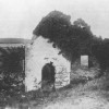
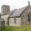
Winterborne Farrington was a separate parish in the south Winterborne valley. Hutchins wrote that by 1773 Winterborne Farringdon was entirely de-populated. Both Farringdon and Winterborne Came were experiencing decline as early as the 14th century. On the site of Winterborne Farringdon only the east gable of St. Germains Church is still standing amid the earthworks of the village it once served.
Other of Dorset’s Medieval Villages’s, which may be noted are:
Modbury is one of two truly deserted villages in the Bride valley north of Bridport, located across the road between Litton Cheney and Burton Bradstock.
Holworth was a village of Saxon origin found on excavation to have had Romano-British occupation on its site. It was part of the Milton Abbey Estate at Domesday.
West Burton and West Ringstead represent two former settlements in a coastal position. West Burton is first mentioned in a Charter of Bindon Abbey in 1313 but was entirely abandoned between the 14th and 15th centuries. West Ringstead is a 10 acre site showing clear outline traces of a village with some remains of the church on land near Ringstead Bay.
Sturthill lies adjacent to its chapel and has a traceable plan. It was disused and in ruins after the 17th century.
Colber is the only authentic deserted village site north of the chalkland belt. It lay west of the Stour opposite Sturminster Newton. Eight acres in size it was a royal manor at Domesday, but is now only a parcel of empty open ground.
Gatemerston is the only instance so far known of a hamlet being spontaneously evacuated by fire. Its exact location is no longer known, but is thought to lie on the West to East Lulworth road.