Dorset Ancestors Rotating Header Image

General

Family History and the Gregorian Calendar

As many people by now will be aware, public interest in family history has increased greatly over the past decade. Genealogy can be a discipline with an almost forensic dimension to it, yet unravelling the complexities of one’s family tree is not an exact science or an easy task. It can lead up many blind alleys or to dead ends. Apart from contingencies such as absent, incomplete – or illegible – parish records there is one very significant pitfall, which the beginner just setting out is unlikely to be aware of.

There is something peculiarly unique about the year 1751 – it was only nine months and seven days long. Strange as it seems, New Years Day has not always been on January 1st. In fact from 1190 to 1752 the New Year began not on January 1st but on March the 25th! From 1190 to 1752 England was using the Julian Calendar devised by Julius Caesar, which was set to run from March 25th (Lady Day) to the last day of the year, the following March 24th. In this calendar the tropical year is approximately 365.25 days, making an error of 1 day in 128 years.

Under an edict issued by the Council of Trent Pope Gregory XIII addressed this error by reforming the Julian Calendar so that the tropical year equalled 365+ 97/400 days or 365.2425 days. The new system named after him also meant that it took 3,300 years for the tropical year to shift a day with respect to the Gregorian Calendar. However, in 1752 Lord Chesterfield passed a bill in Parliament enacting the change over to Pope Gregory’s calendar, which ever since would logically set the first day of each year at January 1st. Since 1752 had to begin on this day, 1751 ended on December 31st – not the following March 24th!

What then are the implications of this change for genealogical or title research? It means that any date from the 1st of January to the 25th of March before 1751 has to have another year added to it. For example, the 11th of January, 9th of February or 23rd of March 1780 would actually be in 1751 for today’s purposes under Gregorian system. Before 1752 the progression of any year’s months commenced in March, so the 29th of April in 1709 would actually be June 29th 1709, not April 29th.

Again, if a document gives a date in any year prior to 1752 written as the ninth day of the tenth month 1736, the month should be reckoned as starting in March, so in this example the month is not (today’s) October, but the December of that time when the document was written. At this point it may be pertinent to remind ourselves that the name “December” (meaning the tenth month) is a hangover from the time when it was just that under the more attenuated Julian Calendar.

Now suppose that a family member or genealogical researcher wants to find the date of baptism, marriages or burial of a Dorset ancestor in a parish register (though this would apply to anywhere else in the country). From what as gone before there is clearly no need for any conversion calculation if the date in question is after 1752 as both past and present are Gregorian and are therefore “in sync”. However, any date before Lord Chesterfield’s parliamentary act of that year which adopted the Gregorian Calendar will not be “in sync” with the present. If a parish register entry for the right person sought indicates that he or she was born on, for example, February the 5th 1649, then to conform to the Gregorian Calendar one year must be added, making the revised date February the 5th 1650.

On the continent and some other countries the further back in time one could go before conversion from the old to the new calendars becomes necessary would be that much greater, since beyond these shores use of the Julian Calendar was abandoned during the latter 16th century. Since family documents dating from before this period are likely to be rare or non-existent the Julian-Gregorian anomaly is a problem mostly confined to British genealogical research.

Since 1752 a number of improvements in the methods and efficiency of record keeping and conservation have inevitably been made. In 1801 the ten-yearly population census was begun in England and Wales, though until 1841 names were not collected, and that year’s census results were unreliable or, because they were only recorded in pencil, often illegible. For the 1851 census another seven pieces of information were required, and further improvements followed in 1891. In 1837 civil registration began in England and Wales, although it did not become a legal requirement until 1874. Since 1538 the Church of England had compiled parish registers, though few of the earliest of these records have survived. However, these records are very uncomprehensive, as they only record church responsibilities, i.e. the baptisms (not births), marriages, and burials (not deaths) of parish natives. Before 1538 there was no official system for recording the events in people’s lives.

It can be seen then that conversion from a written date to the Gregorian date will be necessary for parish records before 1752, but would not concern any national census dates.
Dorset’s Ancient Fields

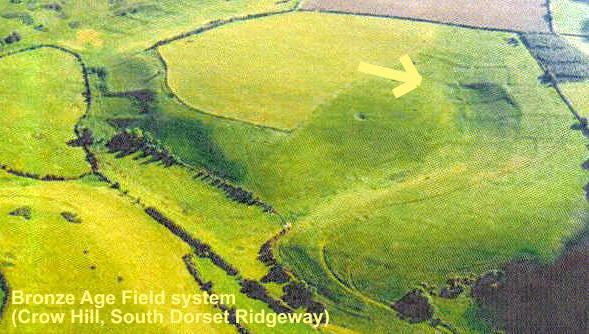
Crow Hill Field System

Crow Hill Field System

Dorset’s Ancient Fields

Generally speaking, Dorset is notably a bonanza for the archaeologist or landscape historian.

Prominent among its prolific remains of early human habitation are the ancient field systems popularly known as Celtic fields, a term used to indicate all fields of regular shape. These are much smaller than the fields of modern intensive arable farming and appear as clusters of square or oblong plots separated by boundary banks. Often, remains of  the farms, settlements and trackways associated with these field systems can still be seen. In one respect the term ‘Celtic’ is misleading, as these field systems also include some laid out later than the Saxon conquest, whereas true Celtic fields are of Iron Age origin or even Roman at the latest, while a large proportion will date from the preceding Bronze Age. 

By the late Bronze Age, the early arable agriculturalists had developed the ard, a light plough that made only shallow furrows in the soil and drawn by oxen along and across the squarish fields. However, where ploughing resulted in downhill creep of the soil, more pronounced linear banks called lynchets often formed. These fields continued in use and increased in number on the chalk downland throughout the Iron Age. Although the number of people was slowly increasing, it should be born in mind that in pre-Roman England the population was much smaller than it is today, so only a small area of land was needed for subsistence crops.

Dorset is an especially fine area in which to see ancient field systems and theassociated settlements and trackways that served them. This is because it is in this county that archaeological field research into these features has been more intense than elsewhere. We can therefore regard Dorset’s field systems  as establishing the model for lowland Britain as a whole. In the highland zone of Britain, however, where soils are better suited for pasture and sheep farming, the field pattern still closely resembles the ancient lowland type. The croft system of the western isles of Scotland may be regarded as a vestige of this elementary subsistence system for sparsely populated areas surviving into the present day.
  
South and south-east Dorset are particularly rich in these field remains, where they cover an area of approximately 4,000 acres. Most are on chalk orlimestone, but some are on the clay-with-flints where this caps the chalk hills or on sandy or gravelly areas. One very clearly defined example of a Celtic field system is visible off to the east side of the Yeovil to Dorchester stretch of the A37 opposite the point in the road known as Breakheart Hill. The field system lies on the flank of a downland spur slightly west of Church Bottom near Sydling St Nicholas and, as in other similarly orientated examples, is particularly well-defined in early morning or evening on a clear day when the sun is low on the horizon. Also, in the presence or absence of sunshine a light dusting of snow can produce a similar effect, the topography being etched out in relief by the casting of shadows.

Six other examples of particular note are:

On the high downland at Turnworth, one can still see today vestiges of a prehistoric field system which once served a contemporary farmstead enclosed by a circular bank. The farm lies to one side of a holloway (sunken trackway) leading off through the fields, which here cannot be dated precisely, but which must have originated at some time between the early Bronze Age (1800 BCE) and the late Iron Age (c100 BCE).

Even more impressive by virtue of its extent is the complex of prehistoric fields that has been revealed from soil-marks on Dole’s Hill near Puddletown. Here a system of croft-like plots over 1000 feet across from west to east is bisected by a stream and penetrated by a winding system of service trackways. The fields and tracks straddle a narrow chalk valley. Not far away, at Winterbourne Houghton, a system of small fields is associated with two former settlements. What is particularly interesting at this location is that one of these settlements had a track leading from it in a north-east direction, which stops abruptly at the line of a modern hedge. Beyond this boundary all trace of the trackway has apparently been erased by medieval and modern ploughing, though the surviving un-eroded portion indicates that it formerly led off in the direction of “modern” Winterbourne Houghton village.

The South Dorset Ridgeway was an important geographical feature in the lives of the early farmers who left behind the traces of fields such as those on Crow Hill. Here, a small complex of plots of the Bronze Age lies at the head of a dry valley or combe, just off from the entrance of which there is a later post-Roman valley-floor enclosure (see photo in the gallery).

Relatively close to Dorchester, Shearplace Hill, again in the parish of SydlingSt Nicholas but this time lying east of the unclassified road to the village, is another site in the county where Celtic fields are associated with a Bronze Age farmstead, and field systems of the prehistoric period have been located and mapped at St Aldhelm’s Head, near the famous 12th century chapel.

A Natural Wonder Double Bill: the Chesil and the Fleet

Even for a county teeming with many natural and historical wonders, Chesil Beach is in a class of its own and something of an enigma. All hypothesising about its origin has been unable to explain why similar offshore spits have not been deposited elsewhere, though tradition has it that the Chesil was laid down in toto during a very severe storm one night. But why should the sea only deposit its pebbles here? Though it is unlikely the legend could be true, the sea became impounded behind the shingle bar, forming the unique ribbon-like lagoon known as The Fleet.

It was the Saxons who gave us the word ‘Chesil’ meaning shingle. At Portland the end of the beach is well defined, but exactly where the western end should be placed has been a matter of dispute. Some authorities maintain that it ends as far westwards as West Bay (to include Burton Beach and Burton Bradstock); while others hold that it ends at Cogden Beach between Burton Bradstock and West Bexington. There is however, agreement that part of the beach is east of West Bexington, and that there the Fleet is at its most spectacular.

Certainly amazing, though less controversial, are the fascinating facts about this freak of nature. The Chesil is 18 miles long between West Bay and Portland, while from West Bexington to Portland it is 13 miles long. In reality the beach is not built up in one terrace but two, against which the waves break upon the lower and discharge their spray over the upper. At its highest the pebble ridge is 45 feet above mean sea level and 200 yards wide to the Fleet. It has been estimated that the beach contains 50 million tons of pebbles, and that if these were packed into the largest lorries permitted on British roads the convoy would stretch from Dorchester to Perth in Australia! Chesil pebbles were collected by the defenders of Maiden Castle, to use as sling-stones against the Roman army when it attacked that hill fort in 43 CE.

The shingle has a distinct gradation along the beach’s length from west to east, with fine creamy-white oolitic limestone pebbles at the west end, known as pea gravel, to large grey cobbles of Portland limestone at the east end. This indicates that the Chesil originated as an east-to-west deposition of long shore drift and could not therefore have been created as a spontaneous storm deposit as folklore implies. It is this gradation of size and texture that gives the shingle bar such a distinctive sound and feel to the soles of the feet. Many have been proud to be able to complete the end-to-end energy-sapping slog that deadens rhythm and makes ankle injury an ever-present risk. 

Fishermen and smugglers have long been able to tell upon which part of the beach they landed after nightfall by the size and feel of the pebbles in their hands. From early times Abbotsbury fishermen have trawled for mackerel off the beach, catching them in seine nets. Daniel Defore writes of these mackerel catches as being so abundant in his day that the fish could be sold onshore at one hundred for just a penny.

No less awesome than the Chesil’s curious facts is its history of notorious savagery towards ships and seamen. Immediately offshore for example, there exists an immensely powerful undertow that can drown even a strong swimmer in only three feet of water five feet from the waterline, and rough seas can throw up fresh shingle banks that can persist for years. During storms the undertow can generate a sucking noise that, it has been said, can be heard in Dorchester. Author Meade Falkner in Moonfleet described how this current caused two fictitious smugglers to fight for their lives in water only three feet deep.

During the age of sail the beach was especially feared. Eastbound ships were in serious difficulties if a storm blew them north-eastwards towards Portland, and there is a sharp shallow water reef that can rip the keels off deep-draughted ships. The combination of the beach’s steep seaward gradient and the underwater current often resulted in shipwrecked passengers and crew being drowned almost in reach of rescuers.

But in 1752 it was said that all of Abbotsbury – including the vicar – were ‘thieves, smugglers and plunderers of wrecks’. In 1822 a Swyre man, Richard Bishop, was jailed for “unlawfully making a light on the sea coast” suggesting that he was signalling to smugglers.

In 1795 seven ships of Admiral Christian’s fleet were lost with two hundred crewmen dead. Then in 1824, during a great storm known locally thereafter as “The Outrage” four ships were lost with all hands (but amazingly the sloop Ebenezer was thrown bodily onto the ridge by a wave, from where it could be re-floated on the Fleet and towed to Portland for a refit). This same gale blew the sea half a mile inland, destroying Fleet village and church before leaving in its wake a hundred bloated corpses on the Chesil shingle. Another storm in 1838 cast five ships onto the shingle bank where they were dashed to pieces, their crews drowned to the last man. A French trawler was wrecked on the shingle bar in 1963.

But the beach has also been the setting for two other non-tragic curiosities. There is a story that  in 1757 a mermaid was washed ashore. It is recorded that many people saw her remains, but they generated little excitement as she was supposed to have been no beauty. Then on May 21st, 1802 the crew of the trawler Greyhound landed a huge fish over 26 feet long, 15 feet in girth and weighing 15 tons; it required fourteen horses to drag it ashore. As this monster was positively not a basking shark, it was more likely a whale shark – as this is the largest fish in the sea – while the “mermaid” may have been a manatee or “sea cow” an animal which certainly could be mistaken for an ‘ugly mermaid’ by people who had never before seen one.

The Fleet is eight miles long, though only seven-and-a-half to fifteen feet deep. At its widest it is 900 yards and just 70 yards at its narrowest point and connected to the sea by a channel less that a hundred yards long known as Small Mouth. The lagoon can be walked beside on the seaward side by the fit and dedicated who can then return along the north side on the Dorset Coast Path. Plants typical of shingle beds grow along the margins such as sea holly, sea campion, yellow horned poppy and sea kale, together with beds of reeds and eelgrass. The Small Mouth has the effect of restricting the flow of seawater, making the Fleet brackish, though towards Abbotsbury the salinity is reduced still further by the input of fresh water from streams draining into the lagoon.

Ecologically the result has been the creation of a richly diverse habitat, making the lagoon a premier nature reserve and SSSI encompassed within the World Heritage Jurassic Coast. A hundred species of plants have so far been identified, and many of these, particularly the eelgrass, provide food for a hundred and fifty species of birds, particularly wildfowl, waders, ducks and geese. The water supports a population of twenty species of fish.

All in all it is not just the shingle that can impress the visitor to Chesil Beach, but the bombardment of the senses from stimuli ranging from the smell of seaweed to the cry of gulls.  And there is also that stark contrast between each side of the walker’s field of perception: to one side the open sea; to the other a marshland thicket. Truly, this must make Chesil Beach a very peculiar and special place.

Unsolved Mysteries of Dorset’s Skies

For over fifty years people have been seeing things in the skies over Britain, many of them in southern England. Popularly known as UFO’s these sightings seem to be outside the realm of our familiar terrestrial aircraft of whatever kind.

Dorset’s Moigns Down is one such area, an ideal spot for a fine Sunday afternoon’s stroll in the country. Certainly Mr J.B. Brooks, a local of this area between Dorchester and Wareham considered it so. He regularly walked his two dogs over the Down on fine days, probably with no thought in his head regarding ancient legends concerning the area, or of its history.

And nothing seemed out of the ordinary when, on the morning of the 26th of October 1987, Brooks left home as usual to exercise his dogs on the chalk hill. By about 11.25 however, high winds which were prevailing that morning had accelerated into a force 8 gale, forcing the walker to shelter up in a timely and conveniently placed ditch or hollow in the ground. Here Mr Brooks rested up, gazing skyward and waiting for the wind to abate so he could resume his walk.

Suddenly into his view intruded an airborne object the like of which Brooks had never before seen or could have imagined. The thing took the form of a small disc or hub, from which a fuselage-like girder or antenna extended forwards, while another three identical projections aligned parallel to each other extended backwards on the other side. But the observer barely had time to comprehend what he was seeing before the next thing happened. In an instant the four girder-arms extending from the disc were seen to separate from one another, forming an equi-dimensional cross, which then began rotating around the central axis.

In his later report of the incident Brooks estimates that the revolving, but stationery object remained in view for about 22 minutes before the extended arms closed up again and the strange, unearthly device left the area of the hill at phenomenal speed.

At this point it is temping to think that the walker out exercising his dogs genuinely bore witness to some sophisticated surveying or reconnaissance devise possibly under the control of an advanced alien intelligence. Certainly from the description of its appearance and modus operandi, the UFO (if that’s what it was) displayed a technological level at least a few decades ahead of our own, for the hub around which the arms rotated appears to have been no more than a few feet across. Yet it was large enough to incorporate a drive mechanism capable of hovering, revolving and accelerating away at very high speed.

While UFOlogists may well favour the alien/space theory, other sceptical experts had an altogether more anthropocentric explanation for the sighting. For instance, it emerged that Mr Brooks had recently undergone a cornea transplant. Debunkers of the space/alien hypothesis ruefully considered the possibility that what Brooks actually saw was a ‘floater’ just a detached piece of skin on his eyeball! It is not known whether the proponents of this medical solution to the mystery were ever asked to explain how a floater was apparently able to unfurl itself and stay revolving for over twenty minutes.

This rather fanciful line of reasoning however is far removed from other technocratic considerations, which could shed some light on the enigma. Moigns Down occupies an area not far to the west of one of the most intensively used military ranges in the country, as well as lying not far west of the Atomic Research Establishment on Winfrith Heath. And it may be significant that in its extended form the Moigns UFO would have been comparable to a helicopter’s main rotor without the helicopter. Could Brooks then, have seen just the rotor of an army helicopter otherwise obscured by a cloudbank, its sound equally drowned out by the gale?

The Moigns incident, however, is not the only recorded sighting in Dorset of an object that does not fit the conventional UFO stereotypes of fiery or glowing – or pulsating – discs, cones spheres or triangles. Thirty-two years later on August 12th 1999 Brian Jones was looking seaward while attending an open-air event near Weymouth when he saw what he likened to a very odd microlite. The object was described as being oblong but with rounded ends and of a dense, dark colour. From the underside Mr James could see that something was suspended. As he was fortuitously carrying a camcorder at the time, he was able to video the object moving slowly on a course north-west towards Bridport, following the line of Chesil Bank while framed against the setting sun. The object did not descend, maintaining a height of approximately a kilometre before disappearing from view after about five minutes.

However, the resolution of the image on Brian James’ video was less than sharp, owing to the lack of available light, although the lens was at maximum zoom. The video footage therefore, was too indistinct for any positive identification to be made, even when shown on local TV news. It was thought the object may have been a parachutist, yet there was no aircraft in the area at the time from which a parachutist could have jumped. Also the fuselage and motor of a normal microlite could not be identified. Neither was any sound heard to come from the object, though the PA system of the nearby function James was attending could have drowned this out. The canopy was the wrong shape for a normal paraglider and furthermore there was no high ground in the vicinity to launch one from other than the risky outcrops of Portland.

The only possible man-made explanation tendered is that Brian James probably saw a powered paraglider, but one with the pilot wearing the motor and propeller as a backpack. But aside from these two unusual cases, there are significantly more which fall more easily into the conventional UFO mould. Six interesting sightings to occur in Dorset can be noted here.

One witness, Jim Horbury, was in Bournemouth on the 2nd of March 2001, when at 2 p.m. he sighted a large slow-moving triangular craft bearing bright lights but making no sound as it crossed the sky at approximately 100 feet. The object was afterwards described as “very frightening.” Then on the 2nd of May 2003, “two orange orbs” were seen to descend rapidly in a double helix formation “as if intelligently interacting with each other” over Bournemouth University. Two sauce-shaped gold-coloured craft were seen to swiftly and silently cross the sky over Parkestone, Poole at 10.15 p.m. on August 9th, 2001.

A flying triangle approximately 100 feet long with blue lights down its left side, red lights down is right. And a pulsating circular light changing colour in the centre was logged at Lyme Regis (10.55 p.m.) Portland (11 p.m.) and at Hengistbury Head (11.05 p.m.) on February 28th, 2002, after having first been sighted in Cornwall. At Winterborne Stickland a 9-year-old boy playing football around 8.20 p.m. one day in August 1991 saw “a large silver disc with a raised centre and red and yellow lights around it” tilt 45 degrees and then head earthwards. A man driving his girlfriend home through Broadmayne at midnight on July 28th, 2002 saw a phosphorescent cone-shaped green light silently and rapidly shoot across the sky.

Dorset Home to the Development of Radar

It would not be an exaggeration to say that Dorset played an irreplaceable part in overcoming the Nazi threat in the 1940’s, and in the preservation of freedom for the world. Not far from Corfe Castle, where for centuries events were played out which are part of our history, on the seaward side of the Isle of Purbeck is where for two years the sciences behind electronic defence, attack and navigation were worked out.

Today, through radio technology we can watch events on the other side of the world as they happen, and view missions to the moon or Mars, and it can all be traced back to Worth Matravers and St.Aldhelm’s Head, on the Dorset coast, not forgetting earlier as well as later research locations elsewhere. Four miles from Swanage, in the early days of the Second World War, a vast radar experimental complex was set up, which was to draw Service and scientific personnel and leading electronic engineers from all parts of Britain. The inventors moved in, academics mixed with mechanics – and it was all hushed up.

From their researches came, perhaps most notably, blind bombing by an amazing new system code-named ‘H2S.’ Later, the Aircraft to Surface Vessel technique was developed to pinpoint U-boats as they hunted in packs for shipping from North America carrying the vital supplies which kept Britain going – one of the greatest threats to our survival – as well as armaments for D-Day and the conquest of continental Europe.

Even the microwave oven owes much to the Isle of Purbeck, although the idea of the cavity magnetron, which was to be used in wartime as a transmitting valve creating echoes, came from two research workers at Birmingham University – John Randall and Harry Boot. Fundamentally, they were the ones who made Worth Matravers famous. Some would say the magnetron won the war.

Microwave links for telecommunications and television have much to thank Dorset for. So have weather forecasting by radar, and navigational aids. Computers came later. Long before the war, though, with Hitler seeking world domination, defence strategies involving radar began to be developed from the mid-1930’s and a chain of early warning stations with tall masts was built all down the east coast and as far west as the Isle of Wight.

With the research station established, the small airfield at Christchurch further along the coast towards Southampton was in use for 18 months by aircraft testing the devices. The aim was to create equipment that would show echoes from the ground or from the sea aboard Allied ‘planes. Sometimes a target aircraft would fly above Swanage Bay, towards or in line with the coast so that its image could be picked up on a screen on the shore.

Reg Batt, in his book ‘The Radar Army,’ relates how echoes were first received at Worth Matravers from a coastguard hut and the chapel of St.Aldhelm, on the headland. The old chapel is now the only vestige of the research station that still exists.

But a moving target was required, so one day he set out along the headland on his bicycle, apparently on his own initiative, with a sheet of metal wired to his machine. This was to lead to exciting results on the screen. They were getting somewhere. But their big task was to reduce the wavelength they used to a few centimetres for clarity, which had never been done before, and to site the equipment they invented aboard an aircraft.

The best brains from the universities, including (Sir) Bernard Lovell, later the inventor of the Jodrell Bank radio telescope, were brought in to get the best results. All this led to the perfection of radio beams and blind bombing with the use of the magnetron valve, so that darkness or poor visibility presented no problem at all in marking the target.
 
Not only ‘H2S.’ but other techniques such as OBOE and GEE were developed in Dorset too. All were vital to defence, navigation and attack. Secret experiments were made with crystal and klystron, where Britain co-operated with the United States, and which was a pulse transmitter of less power than the magnetron. High-powered parties from London and abroad visited the site.

Eventually 17th century Leeson House in Swanage was to be taken over by the research station, which was an easy target with its high masts that could be sighted far out to sea. The position was very advantageous, however, and there was great excitement when distant points such as the Needles and St.Catherine’s Head, 32 miles away, were picked up.

Meanwhile, manufacturers across the country were ready to put the new creations into large-scale production for installation. Giant aerial systems involving dishes looked out on Swanage Bay, a factory production unit sprouted in north Bournemouth, and then came the day when Telecommunications Flying Unit at Christchurch was promoted and moved to a new airfield at Hurn, which was one day to become Bournemouth Airport.

In early 1942 the whole of the Worth Matravers complex moved in to Malvern College, as it was assumed to be under possible threat from commando attack. Defford Airfield in Worcestershire became the associated flying unit housing a large number of test aircraft.

It meant an upheaval for 800 personnel and in some cases their families. The seaside town of Swanage, where many of them had lived, became a quiet Dorset community once again. Masts had to be dismantled and crates packed and as many as 90 removal vans and flatbed trucks would be on the move out of the Isle of Purbeck in one day. As for the workers, they packed their things and left in fleets of coaches brought from all over the area. The move was accomplished in three weeks.

Some of the aircraft flying out of Defford, which included heavy bombers such as Lancasters, Halifaxes and Super-Fortresses, were quick to pick up echoes from the shores of the Bristol Channel, Chepstow and the River Wye. The nearest large towns of Gloucester and Cheltenham were seen almost as on a map. Meanwhile, down below, as in Dorset, the people went about their business completely ignorant of the experiments being conducted in the skies above them.

A terrible tragedy struck in June 1942, when a Halifax heavy bomber crashed in flames in the Forest of Dean, carrying all 11 RAF and scientific personnel on board to their deaths, including A.D. Blumlein, who has been called the foremost electronic engineer in Britain at that time, and who advised the type of television system adopted by the BBC in 1936 rather than the Baird system.

Prime Minister (Sir) Winston Churchill immediately ordered a redoubling of efforts on ‘H2S’ research, and some three years after the principle was discovered the cavity magnetron was installed in many of the RAF’s aircraft by the following year, as well as in U.S. Air Force aircraft. The national radar memorial window was erected in Goodrich Castle, two miles from the Halifax crash scene, in the 1990’s.

While it functioned in close association with Worth Matravers, the airfield at Christchurch, whose runway was only just long enough for the Boeing airliner shipped over from the United States, and which had been adapted as a flying test bed, was Top Secret and had its own uniformed Air Ministry police force.

What a change, and what an upheaval, came over these sedate Dorset towns (although Christchurch was then in Hampshire,) in the early years of the war; then the busy scene changed and the action moved elsewhere. Working conditions were often primitive and without heating.

Yet everyone pulled together, no secrets appear to have been divulged, and in a few years the war had been won, on the Continent, in the Atlantic, in Africa and the Far East. It is difficult to see how it could have been without radar, in which Britain took the world lead. Without that, and the part that Dorset played, world history would be very different from what we know today.

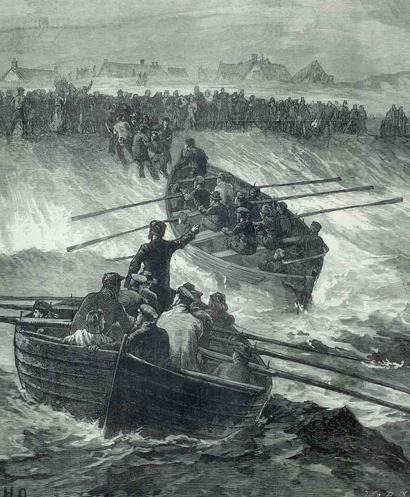
Collision off Portland – 1877

This picture depicts the two Portland Lerret boats launched to rescue survivors of the collision between the Avalanche and the Forest of Windsor off Portland in September 1877. One of these boats was called ‘Black Joke’. Our thanks to David Carter for sharing this picture, which originally appeared in the Illustrated London News.

This picture depicts the two Portland Lerret boats launched to rescue survivors of the collision between the Avalanche and the Forest of Windsor off Portland in September 1877. One of these boats was called ‘Black Joke’. Our thanks to David Carter for sharing this picture, which originally appeared in the Illustrated London News.

Collision off Portland – 1877

This was a night when gale force winds lashed the Jurassic cliffs of Dorset’s coastline, a night when the sea thundered ashore on Dorset’s beaches, and a night when lifeboats saw action but still there were vessels lost and numerous casualties. Furthermore, this was a night when many seafarers sailed their last voyage. And it was a night when the decision to head for shelter or go bare masted into the storm would be critical – and a night when good Captains earned their rank.

Storms ushered in September of 1877 and for seafarers in the waters off the Dorset coast the nights of September 10th and 11th were very difficult.  A French fishing vessel crashed aground on Chesil Beach, all hands lost. Many local Chesil fishing boats were smashed up on the beach. But the biggest loss came as two large vessels both at the start of long deep sea voyages out of London collided off Portland. 

Ploughing down the Channel and in the charge of a pilot was the iron ship Avalanche, her Captain, E. Williams was well thought of by his ship’s owners, Shaw, Savill and Company. He was a seaman of great experience: he and his ship were much favoured by colonists who regularly visited or traded with England. The crew and officers numbered thirty four, to which could be added a steward and twelve foreign seamen along with emigrants and other passengers making a total of about one hundred souls on board the Avalanche, which was headed for New Zealand. Built three years earlier, the ship was rated A1 at Lloyds and was of some 1,000 tons.

The wooden ship Forest of Windsor bound for Sandy Hook near New York in ballast, had departed London at about the same time as the Avalanche. The ship, about 200 ft and nearly 1,500 tons, was built at Windsor, Nova Scotia in 1873; she was owned by Churchill and Sons and was also registered A1 at Lloyds. Her master was Captain Ephraim Lockheart.

On September 10th the wind backed, blowing strongly from the south-west causing huge seas in the Race off Portland. The following evening, with the tide under her, Avalanche sailed close in to Portland Bill in an attempt to steer clear of the tremendous seas churned up by the Race. Rain kept her from the view of the lighthouse-keepers and others watching the sea from the shore.

Captain Lockheart on the Forest of Windsor had been leading his hard stretched crew of just twenty-one men continuously through the turbulent seas encountered during the passage down the Channel. He caught only a glimpse of the cliffs off Portland through the rain. Both vessels hidden from each other by a wall of rain were racing through this turbulent vortex of water, their masters unknowingly heading directly towards each other. 

At half-past nine on the evening of Tuesday, September 11th with no warning, the Forest of Windsor suddenly tore into Avalanche. The ship foundered and all her crew and passengers were lost to the sea within minutes with the exception of the Third Officer, John Sherrington, and two seamen who against all the odds stacked against them managed to get on board the Forest of Windsor. Two emigrant families with ten children between them were amongst those lost.

The Forest of Windsor began to fill with water but remained upright long enough for attempts to be made to launch her boats. Violent squalls of wind and high seas swamped four of the boats but one, manned by Captain Lockheart, his chief mate and John Sherrington from the Avalanche, and nine others was able to get away before the Forest of Windsor capsized.

Peculiar to the Portland area is a fishing boat known as a lerret. Not only is it a good sea boat but has some characteristics of a surf boat which enable it to land through the surf onto Chesil Beach. It was to their lerrets that early on Wednesday morning, several brave Portland fishermen ran. J. Chaddick, John and Tom Way, Tom Pearce, Tom and Lew White and John Flann to one boat and to another went another Flann, another John Way, G. White, Bennett, and J and G Byatt. Later the bravery of all these men was recognised by the Agent General of New Zealand, who sent them all a payment of £5 matching an award made to them by the Board of Trade. A further £130 was collected and handed to the men later in the year.

For several days bodies of the drowned washed ashore on to Chesil Beach and at Portland, Chickerwell and Abbotsbury. The Jury at the Coroner’s Inquest held at Portland on September 15th expressed dismay at the “neglect to provide decently for the interment of the drowned.”

The upturned hull of the Forest of Windsor showed no inclination to sink; it was a hazard to shipping and the Royal Navy ordered H.M.S. Defence under the command of Captain Howard, aided by H.M.S. Black Prince and H.M.S. Galatea to sink the wreck. The Navy attempted to blow the wreck out of the water using torpedoes but these just ran through the wreck. Over the following three weeks it shrugged off gunpowder charges, mines and all sorts of means, stubbornly remaining unmoved. As if to mock its attackers after one assult the lid of a seaman’s chest floated to the surface decorated with a picture of the Forest of Windsor in full sail. The demolition of the wreck was finally accomplished three and a half weeks after the collision at a cost of about £1,000.

There is an illustration of the rescue in the photo gallery.

Where Dinosaurs Walked

Had you been able, 140 million years ago, to stand where Studland, Worth Matravers or anywhere else in Purpeck now are, your surroundings would have been as terrifying as they were breathtakingly primeval. You would have been thrown back to the age of the Dinosaurs, but at a point approximately half-way along in their reign on earth, with almost as long again before the catastrophe in which they perished.

By the end of the much-publicised Jurassic period, south east Dorset was covered by a swampy lake in which the sediments now forming the Purbeck beds were deposited. Here the water margin was frequented by the great reptiles of the day, who left their multi-ton imprints in the soft mud, a substratum which periodically dried out, setting footfalls in what today is the solid rock of the Purbeck cliffs and promontories.

Because of this unfortunate accident of nature in remote antiquity, Purbeck today is not just the centre of a long tradition of aggregate extraction. The course of nature has made it simply one of the world’s premier dinosaur sites. It is a treasure house of prehistory, but one more noted for the traces of these monsters than for their bones. The Purbeck hills have yielded more sets of saurian footprints than any other area of Britain. And the bones which have been found – usually washed up by the sea – hint powerfully at the presence of a dinosaur graveyard somewhere beneath Swanage Bay.

Through excavation and quarrying activity however, it has become apparent that one formation above all others has preserved the great majority of the saurian traces discovered in the Purbeck Series. This is a scorious, pink sandy limestone packed with casts of numerous spire-shelled snails, called the Roach (or Pink) Bed. This bed lies only a few feet below the surface and is fissured horizontally and vertically. In 1962 Geologist J.B. Delair had noted the high frequency of reptilian prints in this bed, but such traces from any other Purbeck beds would not be proved until 1965.

Delair noted that the prints occurred along the bedding. Other clues suggested the saurians were in shallow water just deep enough to keep their tails buoyed up as they waded in deeper, for there are sets of tracks starting well-defined, but which become less distinct with immersion.

In all instances the prints show action: the reptiles were not simply standing or grazing passively. Some appeared to be running or changing direction. Six-inch prints exposed in a quarry near Acton have been attributed to a creature named Purbeckopus pentactylus . Two prints facing away from each other at 90 degrees were discovered in 1936 and another set forming an almost complete circle on the rock bed has also been found.

Delair noted, in a quarry between Worth Matravers and Acton, prints orientated in all directions around a saucer-like depression on a bedding plane. Although several dozen saurian prints in all have been found in Purbeck, barely a handful has been saved for posterity, and most of these have been erased or partly obscured by weather conditions. In 1961 at Herston a fine set of double tracks saw the light of day when E.W. Shuttle re-opened Mutton Hole Quarry. There were 26 prints, and a further trail was discovered here in 1962 which attracted much more attention from the scientific community. The prints were interpreted as those of a Megalosaurus, but no attempt was made to preserve them. The Natural History Unit of the British Museum excavated a further 70 prints from an undamaged section at Mutton Hole.

A quarry at Queensground, Lytchett Matravers, revealed prints of Tri-dactyls, one of which came not from the Roach Bed but a freestone bed four feet lower. This made it the first saurian footprint ever to be found in a bed other than Roach.

Upon the great extinction and geographical change which ushered in the Tertiary era, the dinosaur remains were engulfed in torrents of water bearing sediments which buried their carcasses and traces. But Purbeck’s fossil record bears witness to the next great evolutionary leap – the emergence of the mammals.  One of the earliest deposits of mammalian remains is in the cliffs at Durlston Bay. The remains are disarticulated bones and teeth of some of the earliest marsupials, heralding the scion of evolution that, 50 million years later, would result in the appearance of ourselves.

Princess Victoria’s Tour of Dorset

July 1833. Fourteen years before the first railway tracks are to be laid in Dorset, travel is by horsepower or by sea and at Weymouth the population is in festive mood, excited at the prospect of greeting a 14-year-old Princess who will one day be Queen. It was the start of a royal tour to acquaint the people of Dorset and Devon with the woman who one day would rule over the greatest empire the world had ever seen.

Guns were fired as her yacht appeared off St. Alban’s Point and as the ship dropped anchor off the Esplanade buildings and the royal party came ashore in the royal barge, Royal Salutes were fired

Princess Victoria’s home was Kensington Palace, but Norris Castle on the Isle of Wight was her summer base. Accompanied by her mother, the Duchess of Kent, the yacht “Emerald” was towed by a naval steam packet from Portsmouth. With the Princess was her adored King Charles spaniel “Dashy”. The Duchess was “dreadfully” sea-sick on the journey along the south coast, according to Victoria’s diary, which she kept assiduously throughout and which is today preserved at Windsor Castle.

The townspeople of Weymouth turned out and greeted their royal highnesses as illustrious visitors.  It seemed the whole population was proceeding from the King George III statue to the Quay. God Save the King was played as the royal party mounted the King’s Stairs used by King George III on his frequent holidays in the resort; they were then driven in carriages to the Royal Hotel facing the beach.

The following day after an official reception the princess and duchess travelled in a carriage to Melbury House in north Dorset to be entertained there by the Earl of Ilchester.  They were accompanied out of town by many of the inhabitants and a detachment of Lt.Col. Frampton’s Troop of Dorsetshire Yeomanry. Every prominent building in Dorchester was decorated with flowers, and there were flags waving and the sound of bells and cannons as horses were changed en route to Maiden Newton and Melbury, where according to Victoria’s diary they arrived at about 5 p.m.

A visit to Sherborne Castle had been suggested but did not take place. While at Melbury their royal highnesses ascended a tower and had the shapes of their feet cut on the leads. They enjoyed the park, the lake, the great house, and the church.

After a two-night stay the party was on the road again at 9.15 a.m. on August 1 to be “enthusiastically received” at Beaminster, where there were arches of flowers across the road. The carriage passed through the recently opened Russell Tunnel. The Dorset County Chronicle told of “spontaneous outbursts of enthusiasm” being received everywhere the royal party went.  This was at a time when there was pressure for a republic; it was the period of the Reform Act and agricultural disputes, which in a few months would become illuminated as several agricultural labourers from a small Dorset parish would emerge to become those Dorset heroes forever remembered as the Tolpuddle Martyrs.

At Bridport the ‘royals’ were given a hearty reception by the inhabitants but, according to Hine’s History of Beaminster, were angry that they were “not received by the Mayor and Corporation”.  Then onto Charmouth and Lyme Regis, where there were triumphal arches – and where the “Emerald” was waiting. Every boat in port was filled with paying spectators. Here, in 1685, the Duke of Monmouth landed to lead a revolt against King James II. Mayor John Hussey, in his public address, noted that the princess’s visit was taking place on the anniversary of the Protestant Succession to the throne.

Here, as she boarded the yacht, Princes Victoria was reunited with Dashy her dog. Sailing to Torquay, she remarked on the beautiful coastline and cliffs but both she and her mother were sick on approaching Torquay. From there, after an overnight hotel stay it was off by sea to Plymouth for several days in Devon.

On August 7 an informal return trip was made by coach, changing horses at six places including Bridport and Dorchester, with a military escort from Winfrith to Wareham and Swanage. Passing Corfe Castle, the princess noted in her diary some of the climactic events in history that had taken place there. The reception at Swanage was unforgettable for the young princess, and she must have been sorry to leave Dorset as she embarked with her mother on the “Emerald” for “dear Norris.”

It had been close on six weeks of strenuous activity since they left London. The ‘Royal Progress’ was one of a number leading up to the crowning of Queen Victoria. When that happened, exactly five years after her tour of Dorset, the county must have been proud to have been part of the grand design.. In Sturminster Newton, Gillingham, Cerne Abbas, Sydling, and Evershot, there were demonstrations of loyalty on the occasion of the “beloved Queen’s” coronation, but most of all perhaps in those communities the Queen had visited as a girl. Celebratory dinners were held in Ilchester and Lyme Regis, and at Dorchester there was a ball and much merriment at the King’s Arms and a gathering at the Antelope Hotel and a band wound its way around the streets.

Residents of an almshouse in South Street were regaled with roast beef, plum pudding and beer. At Weymouth, meanwhile, all the shipping in the Bay and Portland Roads was gaily attired and there was a procession along the Esplanade. Along the coast at Poole no less than 2,000 Sunday school children gathered for a “substantial dinner”, while vessels at Bridport Harbour were dressed overall.

Victoria, who first learned of her destiny at the age of 10, moved into Buckingham Palace. Her marriage to Albert was to come. She served as queen until 1901, becoming Empress of India in 1876, creating a new ceremonial style of monarchy, with social rather than political emphasis, and thus preserving it, and giving her name to a whole new age of modernism and expansion.

Notes: Extract from Dorchester’s Municipal Records relating to this story:

1833: Aug 2nd. Locket, for ringing on occasion of the Duchess of Kent and the Princess Victoria passing thro’ Dorchester (Per order of the Mayor) £1.0s.0d.

Paid Oliver, Churchwarden of The Holy Trinity (Per order of the Mayor) expenses incurred on the above occasion £1.17s.0d.