Before we can delve into some of its secrets, even the name Purbeck is of obscure and uncertain origin. The earliest reference is in 948 AD, where it appears as Purbicinga, later as Purbic in many medieval documents. But other place name authorities variously suggest the Old English pur (a bittern), and the element becc, a point or headland or becca, a pickaxe or mattock.
Besides the uncertain origin of its name, Purbeck is an island of unresolved riddles and ritualised dead. As good a place as any to start would be at the Promontory on the south side of Poole harbour known as the Goat Horn Peninsula. Near to its base are the foundations of a ruined church, with other settlement remains in a shallow valley of what today is oak woodland just west of the Goat Horn railway at or near a place called Newton. But nothing of Newton survives as a viable settlement today. It is a place vanished from the face of Purbeck, yet Newton was to have been the fulfilment of Edward I’s vision for an entire new town and port on Poole harbour.
Oddly, the foundations of the church building were never recorded by surveyors of the Royal Commission for Historic Monuments, suggesting the foundations are not those of a medieval building. Furthermore, the oaks in woodland have been dated to the earlier 16th century, and are therefore too late to have been planted as part of Edward’s planned town. Yet Newton is clearly indicated as a settlement on a map of 1597, suggesting something was built here once – and in any case, how is it that the name Newton has survived?
There exists a document of 1286 stating Richard de Bosco was appointed to lay out a new town “with sufficient streets and lanes and adequate sites for a market and church and plots for merchants…” in a place called Gowtowre (Goat Horn?) Super Mare. But it is generally thought the silting of the harbour and the unfavourable situation of the site detached from the Dorset mainland probably killed the scheme.
What became of the road, which must once have connected the Roman ports and industries in Purbeck with Durovaria (Dorchester)? The question has been exercising the minds of archaeologists for some time, for no trace of a Roman road has yet been found. The explanation, which is common currency at the moment, holds that, as the communication was merely local rather than arterial (as roads emanating from London were). The Purbeck road was simply a flat metalled track, which the Romans did not bother to provide with a cambered hardcore foundation (agger), or with drainage ditches. There was no earthwork, and so the superficiality of the structure would understandably make it less inclined to leave traces after two millennia. Furthermore, the development of the Purbeck industries came mainly after the building of the main Roman road network.
Even more mysterious and perplexing for archaeologists is a discovery on heathland west of the South Haven Peninsula. Concentrated in an area between Redhorn Quay and Jerry’s Point are no fewer than 71 earthen ring-banks ranging from 45 to 150 feet in diameter. Although the banks are about 20 feet across, they are only about one foot high. Another six circles lie just to the south near Brand’s Ford, and 50 (once about 100) more cover the ground south west of Squirrel Cottage at East Holme.
The interiors of the circles are typically flat or slightly concave, hinting that one of two may have been ponds storing rainwater for short |periods, but the function of the others remains completely unknown. Of some significance however, has been the observation that trees established in some of the circles have grown larger than those of the same species elsewhere have. Two circles excavated in the 1960’s were found to contain burnt furze, which may point to a feeble explanation for the enhanced tree-growth but little else. No artefacts, which could have conclusively dated the structures, have ever been found, and the best estimate has been that they are not earlier than the Iron Age or later than 1700 AD. The lower end of the range is based on the finding that one or two of the rings impinge upon Bronze Age barrows and are therefore assumed to be later.
But associated with the northern group of circles are thirteen low sandy mounds, and an alignment of five evenly-spaced stones with a sixth lying off-centre at the north end occupy the centre of the South Haven Peninsula. Some of these stones have fallen, but like the circles and the tumuli they have so far defied explanation.
The 19th century antiquary Charles Warne describes another curious rock of Purbeck, this time entirely natural. This is the Agglestone near Studland, a great anvil-shaped 400 ton boulder which for thousands of years sat perched on a sandy hill (it eventually toppled over in 1970), It is now known that the Agglestone is an example of the outlier or lens of more indurated gritstone weathered out from its enclosing Bagshot Beds, but traditionally it has been accounted for in more prosaic, folklorish terms as thrown or placed by the Devil, prehistoric man, or brought by a glacier. The name may have its roots in the Old English word for hailstone, suggesting that the Agglestone fell from the sky.
While the Agglestone holds only a folklore tradition with no mystery attached, the same cannot be said for Harpstone. The Harpstone is no natural erratic but a seven-foot limestone menhir set up by prehistoric men beside a stream and a coppice in the Corfe Valley south east of Steeple. Isolated standing stones are rare in Dorset (although there are circles and rows) and were it not in Purbeck the Hartpstone’s environment would argue against prehistoric origin. Instead, its presence may indicate early Bronze Age penetration and clearance of the Corfe valley. Yet the “stone” part of the name does not appear in a document until 1340 (as Herpston); if it could be proved the stone part of the name is older, we would have evidence of greater antiquity.
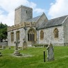
Then there is the gravedigger at Studland Parish Church who in January 1951 struck a stone cist while digging a grave. Lifting the lid, he found the sarcophagus contained a skeleton with its skull detached and the lower jaw placed behind it. The cist, which had been constructed of Purbeck marble slabs, was more than long enough to contain the body fully extended. The decapitation therefore, was not for want of space. In his pathology report Professor John Cameron determined that the skeleton was of a woman in her thirties. A Kimmeridge shale spindle and a number of cockle shells had been buried with her, initially suggesting a Romano-British date, as J.B. Calkin, who had excavated the Studland cist burial, had also excavated a 3rd century grave at Kimmeridge containing a woman buried with her head placed at her feet and with the jaw removed.
But the Rev J.H. Austen had excavated crouched burials in Bronze Age barrows with the jaw placed behind the skull, presenting the possibility that the Studland sexton had stumbled upon a Bronze Age cist burial older than first reckoned. In the DNHAS Proceedings for 1952, Calkin wrote that the Bronze Age people of Purbeck might have had “..a very lively fear of being haunted by the dead” and so had practised the mutilation of corpses to prevent the dead from walking and talking.
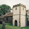
On the ridge between Creech and East Lulworth, at the boundary of Tyneham and Steeple parishes, there is an ancient crossroads long known as Maiden’s Grave Gate. This ominous name preserves the memory of an 18th century girl who killed herself and consequently was denied a Christian burial. Indeed, as the law then required she was buried at the crossroads – buried, it was believed, with a stake driven through her heart! At this place too, there stands an oak, into the trunk of, which has been carved two coffins. It seems that only three hundred year ago superstition extended to taking measures to prevent the appearances of ghosts.